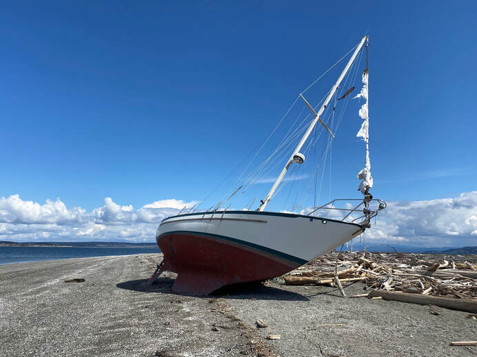
 I’d just heard on the car radio that it was the anniversary of the sinking of the Titanic (April 15, 1912). Then I arrived at Long Point and found this, a ship had floundered on the beach, flags still flapping in the brisk spring breeze. I scanned the water for icebergs. Though spring has been long in coming, on this day the sun shone brightly and sent puffy white clouds sailing across the deep, blue sky. I approached the stranded vessel trying to imagine it's mishap. Had it broken loose of its mooring and washed ashore with no one aboard? Were the sailors unaware of this long point at high tide despite the name on a chart? Had the wind been overpowering, the current too strong to avoid sailing onto the beach? At least, it was a low, sandy beach and not a rocky, inaccessible bluff. No harm done, not much anyway, except the embarrassment of your sailboat lying up on the beach for all to see. It reminded me of how I’d almost suffered the same fate once just north of here. A strong wind from an unexpected quarter, drug us off our quiet anchorage late at night. We were in an historic long boat powered only by oars and sails. It was dark. The wind was howling. Waves were pounding our little vessel. We radioed “May Day”, donned our survival suits and were rescued near Deception Pass. But this day was bright and promising. It was low tide and I was out for a relatively uneventful walk between Long Point and Coupeville. No life rings or survival suits necessary. There was plenty of sunshine and white sand though a cool breeze kept me bundled up in all my layers. I made my way westward. Beyond the beautiful waterfront homes the bluff rose high up on my left. A few trees grew just above the sand trying to hold on to the sluffing soil. Maples were leafing out in their chartreuse party dresses showing off their dangly earrings. A few trees had tipped over and I was glad I had a wide beach to navigate around them. If the tide were higher, it would be quite the logstacle course. I approached a little spring trickling out across the sand where bright green algae grew. A perfect place for otters, I thought, and I looked for tracks. Instead I was accosted by kingfishers rattling around me. Eagles called from the tree tops high above. One called to another as a third cruised by. Ravens croaked from the forest. Hummingbirds zipped to red flowering currant. Mergansers, goldeneyes and eared grebes paddled just offshore. Gulls and crows hopped along the water’s edge picking up bivalves, lifting off and dropping them on the beach. Crack! It was an all-you-can-eat buffet of mussels and clams. I was getting hungry, too. I passed another cluster of beach cabins. These were more modest and looked like they had some history. When I was here last summer, people were out cleaning kayaks, roasting hot dogs and marshmallows. I walked on and again the bluff rose above me. Around the corner my favorite house came into view. It looks like the home of a pirate, or a wizard, or some other whimsical creature, with its red cap and green cape. That's where I turned around, within sight of Captain Coupe Park with it's boat launch, dock and picnic table. I took a picture of the Coupeville Wharf and headed back. I could hear the subtle swish of the tide changing and didn’t want to get stranded somewhere along the way with the high bluff towering over me and not enough life boats. Maribeth Directions: This beach can be accessed from the Captain Coupe Park on 9th Street in Coupeville, 6 blocks east of Main Street. Or from the stoplight at Main Street and Highway 20, drive south 2.7 miles to Morris Road. Turn left and take a quick left onto Parker Road. Drive 1.3 miles and turn right on Portal Place. In a short distance turn left on Marine Drive and follow it to the end.
Bus and Bike: Fare free Island Transit route 1 and route 6 go through Coupeville on Main Street. You may get off at the Methodist Church and walk or ride east 6 blocks on 8th (a quieter street for pedestrians and bikes), then hop north 1 block on Gould to 9th and go one more block east to Captain Coupe Park. Walk east on the beach. Mobility: The Long Point end of this walk is a soft, sandy beach. However, there are driftwood logs and the beach sand is too soft for most wheels. The beach gets rockier as you go toward Coupeville. Captain Coupe Park has a dock, boat launch, picnic table, barbeque and restrooms on a gently sloping lawn.
0 Comments
Your comment will be posted after it is approved.
Leave a Reply. |
Authors
Maribeth Crandell has been a hiking guide in the Pacific NW for over 20 years. She's lived on Whidbey and Fidalgo Island for decades. As a frequent bus rider she easily makes connections between trails and transit. Archives by date
April 2024
Categories
All
|
 RSS Feed
