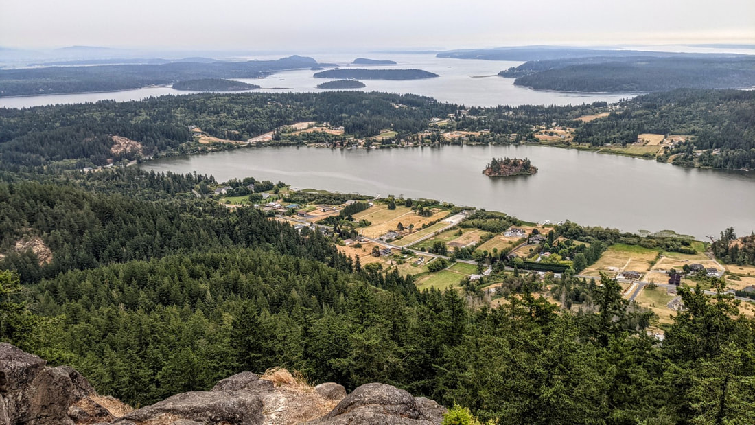
 The runner is rewarded with the tape at the finish line. You are rewarded with the view at your feet. Terry and Renny Russell, On the Loose August 1. It’s early morn. Clouds hang low. A handful of raindrops speckle my windshield. I drive to Whistle Lake’s trailhead; I see just one other car. Signs nailed to trees say “High Fire Danger – No Smoking, No Fires”. It’s a tinderbox out here. My goal is to hike to the top of Mt. Erie from Whistle, to celebrate the new day and new month, and to honor a friend who had passed away just yesterday morning. I hike to the lake, muted in the overcast gray before sunrise. Doesn’t look like there will be a sunrise today. Squirrels in treetops chatter with others nearby. As I stop to listen, something falls with a loud thunk close to me -- a Doug fir cone. Then comes the noise of something else falling through the branches, and another thunk. That cone just misses me. I move on. I hike along the lake, climb up to Trail 21, follow that a short while, then turn west on Trail 207. It drops a little, then quickly begins climbing the east side of Mt. Erie. I hear a nuthatch. A Bewick sings. Then an owl asks who is cooking. Then another, a juvenile, screeches a plaintive wail of hunger. Then more cones fall through the tree branches, landing nearby like a bombardment from above. I move on again. The trail climbs steadily through the lower woods, through lush sword ferns and firs and maples. But soon I begin to notice that not all is lush. Many of the salmonberry leaves look like green potato chips, shriveled on their branches. Indian Plum leaves have turned mostly yellow. Fallen maple leaves litter the trail and forest floor. I keep climbing. Trail 207 meets Trail 216, where a decrepit sign hints at directions. The trail is level for a while, a pause before climbing the mountain in earnest. Soon I am scrambling up rock faces, stumbling up steps of tree roots, always going up and up and up. Beads of sweat dampen my shirt. I stop to drink water – lots -- to lighten my pack. I now regret carrying an extra sweatshirt in my pack. Just in case, I had reasoned. Just more sweat, I now realize. I reach the trail’s meeting with the paved road coming up the other side, then climb even steeper sections of the trail as I begin the final quarter mile of ascent. Beside me are boulders covered in the curled brown fronds of ferns, looking dead. More green fir cones fall from above. I climb a hundred feet up on a trail made of rock faces, drink more water, then enter a green valley. Now I know I’m getting close. I look for it, and a minute or two later I see it: a sign on a tree that says one simple, glorious word: summit. This peak is the highest point of land of all the hikes in our book. The final stretch is over quickly. I emerge at the Mt. Erie parking lot, then walk to the view out over Campbell Lake, over the islands in Skagit Bay, over Whidbey, over Rosario Strait, and over where the Cascades and Olympics should be except they are hidden in clouds and fog and smoke. I smell smoke. A cool breeze wicks through my shirt and chills me quickly. I put on that sweatshirt in my pack, glad I carried it now. I watch the day begin. A new day. A gift we all have, if we are alive. A day to keep alive the memory of those no longer here, and to treasure the gift of those who are. I raise my hand in memory of my friend. It’s time to go back down. And watch out for falling cones. jack Directions: From Whidbey Island go north across Deception Pass Bridge to Sharpe's Corner roundabout and turn NW toward Anacortes. From Mt Vernon take Highway 20 west and straight through Sharpe's Corner roundabout. At Commercial Ave. in Anacortes, take the roundabout south up the hill to Fidalgo Avenue where the road comes to a T. Turn left, or east, and go to the stop sign near the Catholic Church entrance. Turn left, and circle the cemetery going north, onto Hillcrest Drive, and then east, and then south which is now Whistle Lake Road. In 0.9 miles the road turns left, then right. Follow the signs. The pavement continues straight but signs will point right again down and then up a dirt road for about a quarter mile to the Whistle Lake parking area. It's sounds confusing in writing, but once you are on Whistle Lake Road, you can follow signs all the way to the lake.
Accessibility: the trail is steep, narrow and with numerous roots, rocks, and other awkward terrain. Did I mention that the trail is steep in places? Transit access: none. Bicycle access: Whistle Lake road is narrow but has a low volume of traffic. Mileage: The mileage of this route is about three miles one way. Of course it seems longer than that going up, and much shorter going back down.
0 Comments
Your comment will be posted after it is approved.
Leave a Reply. |
Authors
Maribeth Crandell has been a hiking guide in the Pacific NW for over 20 years. She's lived on Whidbey and Fidalgo Island for decades. As a frequent bus rider she easily makes connections between trails and transit. Archives by date
April 2024
Categories
All
|
 RSS Feed
