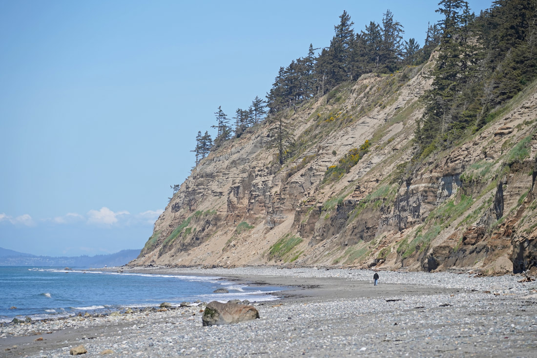
 Yep, Californians must dream of being able to hike a beach like this. First there is ample parking – and it’s free, or better yet, you can ride your bike or take the bus here. This is a beach where you will see more whimbrels than people, where you can surf without the music of a beach blanket bingo party in the background, where millionaire homes don’t intrude, where the air is clean and clear, and where snow-covered mountains relax in the background, sharp and inviting. The sound of the surf is the constant soundtrack for the entire two-and-a-half-mile hike in each direction. And the bluffs lining the beach also speak volumes, in muted voices unless we pay close attention. Sixteen thousand years ago, this land was buried under 4000 feet of ice, laboriously grinding south to Olympia, then receding north to Canada and the Cascades. For several thousand years they had scoured Whidbey, then rebuilt it with castoffs from its excavations. These bluffs stand as stark reminders of the flow of time and energy in a world that had cooled just a handful of degrees. The glacier pushed the salt waters of Puget Sound away. When the ice retreated, large lakes formed from meltwater and the many rivers still coming out of the Cascades and Olympics. Most of these lakes disappeared when the glacier retreated up Whidbey, once again allowing the ocean waters of the Strait of Juan de Fuca to fill the waterways we see today. Walls of sand over a hundred feet high line the north half of this beach. These walls erode quickly as wind and waves dig at them relentlessly. The eroded sand fills the beach here and for miles to the north as the currents carry the sand along. Here's a YouTube video of the sand waterfalling down the cliff: https://youtu.be/if_Kqz40rK8 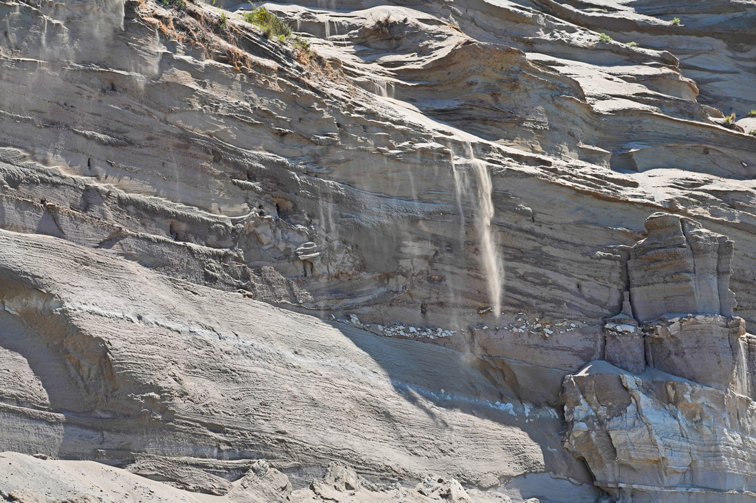 The south half of the bluffs is glacial outwash, the typical glacial till we have all come to know and hate – a texture like gravelly concrete, with larger rocks thrown in as the melting glacier dropped its load of scoured debris. The beach is rocks and gravel beneath these bluffs. The action continues. Waterfalls of sand rained down the bluffs as we walked along. Larger piles of sand lay at the bottom, eaten away with each high tide. Further down, a large cabin-sized slump of glacial till had broken off the bluff. Hopefully, no one is underneath when this happens again, which it will! We played leapfrog with the whimbrels, marveled at the flight of seagulls, and watched crows shoo an eagle out of ‘their’ neighborhood. Surfers waited just offshore for good curls to ride back in. The south end of the beach has a house built out into the shoreline, requiring a rock riprap wall to protect it from waves, temporarily. You can only get around this obstruction with a tide of less than four feet. The tide was rising, almost at four feet now. Another hour and I would have been too late. We were back at our car, ready for a snack, and one last look over the entire stretch of coastline we had just hiked. The sandy strand still beckoned, a world apart from the busyness of our normal lives. The sunshine and warmth made us smile. Waves rolled in with their steady soothing surf song. The islands and mountains in the background made it all seem so dreamy. Dream on, Californians. jack Directions: From Highway 20, 4.4 miles south of Oak Harbor, or 6.4 miles north of Coupeville, turn north onto Hastie Lake Road and drive to Hastie Lake Beach Park. Or park at West Beach County Park on West Beach Road at the north end of this hike.
By Transit: Take Route 6 which follows West Beach Road near here. By Bike: the roads in this area are rolling with an occasional steep section. They are somewhat high speed, with minimal shoulder, but low volume. Mobility: the beach is a mixture of sand, gravel, and small boulders. Note: Check your tide calendar! There is NO place to get above a full high tide for most of this beach, especially in the winter. And the tide must be below the four foot level to get around the rock rip rap at the south end, and to make for easier walking at the north end.
0 Comments
 Watch the YouTube video of the hike first to get a better feel for the experience of the trail. Click here for the video. Put it on a bigger screen than your phone, for sure; then turn up the volume, sit back and immerse yourself in this world for four minutes. "Land is not merely soil, it is a fountain of energy flowing through a circuit of soils, plants, and animals.” – Aldo Leopold “The soil is the great connector of lives, the source and destination of all. Without proper care for it we can have no community, because without proper care we can have no life.” ― Wendell Berry Cow poop. That’s the first odor to reach my nose. Or is it freshly turned compost? No difference between them, really, not in my nose anyway. Thus I began hiking the Beach View Farm Trail. The trail accentuates all four words of its name, with a magnificent beach at the far end of the hike, a big sky and ocean view for the entire route, and farmland on both sides of the trail for much of the hike. Bookending it all are wetlands, forests, scattered homes, and native habitats for an incredible diversity of life, both wild and domestic. I find this trail to be my meditative place, my grounding place, my reminder that my life, and yours, is totally dependent each day on the earth and sea being healthy enough to grow what we need, and totally dependent on certain people to gather what is grown so that we may live yet another day. So it was on this day in early May that Kath dropped me off at the east end, near the church, to let me wander down the trail slowly, lost in thought and wonder. Wonder. That quality that senses the magic, the miracle, in all that is around us and within us, every day. An eagle calling to its mate, a dandelion cypsela ready to launch, a hundred shades of spring green leaves bursting forth, and songbirds serenading their heartfelt melodies – what a gift to be known by your song, right? I watched a heron for several minutes as it moved all of two inches along a waterway, focused on its next meal. Big beefy cattle ruminated about life inside a fence, while a doe did the same walking freely through the meadow nearby. Geese swam with their next generation, and red-winged blackbirds looked for a mate to create the next generation. The Timothy grass grew, a fertile fountain of energy fed by the life-giving sun and soil. Chickens dined on whatever insects they found in the field, and then fertilized the farm soil with their droppings. Yes, there is poop – it happens. It’s a farm, it’s real, and it’s essential. Did you know that in the year 1800, 94% of our nation lived in a rural setting? A trip to town was about buying staples, not groceries. In fact, the first grocery store would not open until 1916. Where was all the food? It was in homes, gardens, local fields, and forests. It was in the pantry, the cellar, the backyard. By 1900, just 40% of our citizens were farmers. Today, that number is down to just… just 1%. I met up with Kath where the trail enters Swantown Lake County Park, and we wandered the trails through the forested meadows and near the wetlands of the lake. Sprinkles began to fall. I looked back across the entire trail I had just hiked. Peace reigned. The circle of life rolled on. jack “To forget how to dig the earth and to tend the soil is to forget ourselves.” – Mahatma Gandhi “The care of the Earth is our most ancient, most worthy, and most pleasing responsibility. To cherish what remains of it and foster its renewal is our only hope.” – Wendell Berry __________________________________________________________________________________________________ Directions: From Highway 20 south of Oak Harbor, take Swantown Road 1.4 miles northwest to Wieldraayer Road. Turn into the Christian Reformed Church parking lot; use one of the 8 parking stalls on the lower end of the lot, devoted to trail users, which heads west from here along the road to the trail. Or, park at the West Beach County Park on West Beach Road and walk south 300 feet to a gravel road that leads to Swantown Lake County Park, which is the west end of the Beach View Farm Trail. By Bus: Route 6 connects Coupeville with Oak Harbor by traveling along West Beach Road. By Bike: the roads in this area are mostly low-volume, and hilly, and with narrow shoulders. West Beach Road is high-speed in places. Mobility: the trail is mostly compact gravel through the farmland, fairly wide and gently sloped. The trails through the county park are narrow, generally soft and grassy, and also gently sloped. Dogs: Pets are NOT allowed on the Beach View Farm Trail; they ARE allowed in Swantown Lake County Park if they are always on a leash. That is why Murphy is not in the movie until the very end. 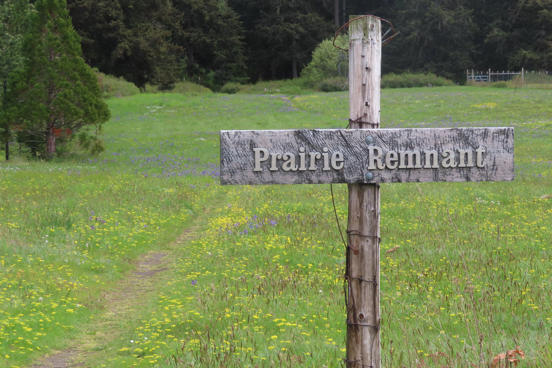 Last month I got to see a California condor, one of the world’s rarest living birds. With a wingspan of nine to ten feet, they’re the largest bird in North America. I never thought I’d see one in the wild. Due to DDT, lead ammunition, poaching and habitat loss, their numbers dwindled until in 1987 there were only twenty-seven condors left. Those last few were captured and bred in captivity. Beginning in 1992, they were released into protected places like the Grand Canyon, Zion and Pinnacles National Parks. Now the population is around 560 condors, still critically endangered. I want to personally thank Rachel Carson for writing Silent Spring, a book that raised the alarm about toxins that were threatening many species of birds. Her efforts, and those like her, have preserved our iconic bald eagle, as well as the California condor and many others. Without her voice, I would not have had the thrill of walking among the towering cliffs and seeing the soaring condors spiraling overhead. I’d like to thank her, but I can’t. Her influential book, Silent Spring, was published in 1962. She died 2 years later in 1964 when I was still a toddler. However, others have picked up the torch. Last month the Orca Network celebrated the return of the Grey Whales with their Welcome the Whales Festival. Grey Whales were overhunted in the late 1800’s and early 1900’s. Atlantic populations became extinct. Here on the west coast, their 10,000 mile migrations close to shore made them vulnerable. In 1950’s they, too, were near extinction. After being protected by law, they made a comeback here. Now there are an estimated 19,000 Grey Whales in the eastern Pacific. In 1992 they were removed from the Endangered Species list and are still safeguarded by the Marine Mammal Protection Act. The advocates who protect these rare species have my deep gratitude and admiration. The Whidbey Camano Land Trust and the Pacific Rim Institute preserve rare plant species like the Golden Paintbrush, found in only 11 places in the world. It is just one of the wildflowers protected in a few prairie remnants near Coupeville. Less than 1% of the native prairie remains on Whidbey Island. The Salish people harvested camas bulbs, another native wildflower, as an important food source. They helped maintain the prairies using fire. Native plants of the prairie, adapted to drought and fire, have deep roots. Fire burns off invasive plants and small trees, so the prairies thrived. Periodic controlled burns are still used to help the native plants compete for water, nutrients and space. Recently at Pacific Rim Institute, walking between the former pheasant coops, swallows swooped and swirled around me. Turning the corner at the old barn, a song sparrow eyed me suspiciously. I followed the line of trees noticing the carpet of yellow and blue blossoms on neighboring land. A savannah sparrow perched by the Prairie Remnant sign and sang like a doorbell as I entered. The old farm road turned but I went straight along the narrow path and carefully walked among the blue camas, spring gold, white chickweed and buttercups. Here and there I spotted a chocolate lily. Approaching the fenced field I looked closely for the golden paintbrush. White crowned sparrows sang from the wire competing for my attention. Circling the fenced field, I noted the huge fir trees beyond. A pair of California quail scurried between hedges of wild roses. I turned back toward the farm road and spotted two men examining the flowers. On my way by the barn I passed Jay, a Whidbey Audubon bird expert. They will be here for the annual Wings Over Whidbey along with the Pacific Rim Institute’s Prairie Days on May 11. I am so grateful to live among people like this, who educate, inspire and protect this amazing place we call home. Thank you for this 1%. Maribeth To find out more about Wings over Whidbey and reserve your spot to go out with bird experts to key birding sites on the island click here. To learn about the Pacific Rim Institute and Prairie Days click here. Volunteers are always welcome to help preserve the prair Directions: Take Highway 20 about 3 miles south of Coupeville, turn onto Morris Road. Then turn onto Parker Road and drive ¼ mile. Look for the row of white sheds.
By Bus and Bike: Take fare free Island Transit Route 1 to the Morris Road bus stop 3 miles south of Coupeville. Walk a short distance to Parker Road and turn north toward the row of white sheds. Two bikes fit on a bus bike rack. Morris and Parker Roads are quiet and have a wide shoulder. Please wear bright clothes when walking or biking by the road. Mobility: The old farm roads are wide and mostly level with a packed gravel and sand surface. The farm road can be followed in a loop starting between the sheds and staying left, passing the turn along the line of trees, turning left again at the old barn, and left again at the next turn. The trail through the Prairie Remnant is very narrow and may not be accessible for those with mobility challenges. However, there is a mound of prairie flowers next to the first shed and close to the parking area.  “To love a place is not enough. We must find ways to heal it.” ― Robin Wall Kimmerer, Braiding Sweetgrass Once upon a time, there was a wetland surrounded by forests and beaches. The ponds hosted a diverse habitat of plants and wildlife that called it home for thousands of years. Tribal members lived on the beaches nearby. It’s an oft-repeated story: new people moved into the area, cutting down the forests for houses and stores, building factories on the beaches, and plowing wetlands into farms. This new town they called Anacortes. The town grew and grew. Houses multiplied, farms flourished. One farm in the lowlands below the high school was owned by a family named Smiley. Much of this farm had once been the wetlands. Eventually, some of the farm became playfields, and some of it grew back as forests and wetlands. All these lands became known as Smiley’s Bottom. Below: the farmland to the left of the second U in Museum is now the wetland and woods being restored at Smiley's Bottom. The farmland to the right of that line is now Volunteer Park's ballfields and playgrounds. Skyline and Washington Park are at the very top of the photo. 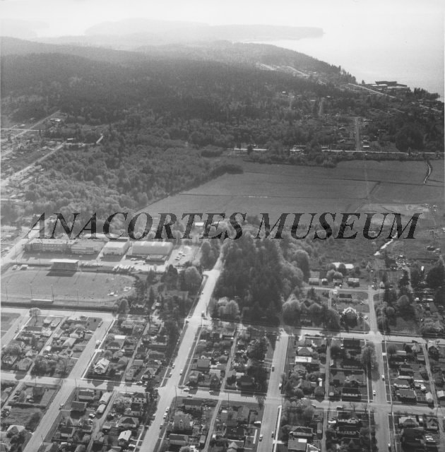 In recent years, the north end of Smiley’s Bottom became Volunteer Park, a collection of formal ballfields and grassy play areas. The east end is now a large open grass field used for lacrosse, football, and soccer. The south side is returning to its roots as a forest and wetland. As a hiding place close to the high school in the middle of the city, Smiley’s Bottom became a hangout for youth parties, vandalism, and garbage. Neighbors found a large fort built well off the beaten path, made with trees cut down from the nearby forest, with hundreds of beer bottles scattered around the party site. And neighbors noticed that the wetland, now protected by law, had park and school developments encroaching into the wetland. It became time to truly care for Smiley’s Bottom. School and Parks Department folks removed the fort and the stumps of trees that had been hacked down to make it. They hauled away beer bottles, fire pits, and old tires. Damage to the wetland was mitigated to begin the restoration of this precious and vital habitat. The trail through the wetlands and woods became formalized and modernized to allow trail use in all four seasons and to encourage public visitation. Kath and I walk these trails often. Here in the middle of town, beneath the hill of the high school, amid dense neighborhoods and sporting events of all kinds, Smiley’s Bottom is once again becoming a healthy wetland world of its own, a haven of habitat, a sanctuary for wildlife that still calls this place home. Today was Earth Day, 2024. The scent of cottonwoods filled the air as we walked to Smiley’s Bottom from Volunteer Park. Sunshine blazed, warming our hearts with the feeling of spring. Songbirds sang joyously – red-winged blackbirds in the tules, song sparrows in the alders, chickadees and even goldfinches in the canopies above. Ponds reflected the bright green of willow leaves, reeds, and grasses. Salmonberry flowers were changing into berries. Humongous skunk cabbage leaves rose out of muddy channels. Farther south we entered the hall of maples, the trail meandering through the wide open, drier forest just above the wetland. Ferns raised their fiddleheads to greet the spring. Pac wrens filled the airwaves with crystalline music. At the southeast corner, I climbed the hill next to the high school. From this vantage point, I could look north over what was – once upon a time – nothing but wetlands and woods; which became farms, and then houses, playfields, and a big city. At my feet, in Smiley’s Bottom, nature is returning. A redtail hawk glided overhead; insects buzzed; life flourished. The wetlands as seen today from west of the high school, looking north across Smiley's Bottom to Volunteer Park. Guemes Island and Lummi Island rise in the distance. 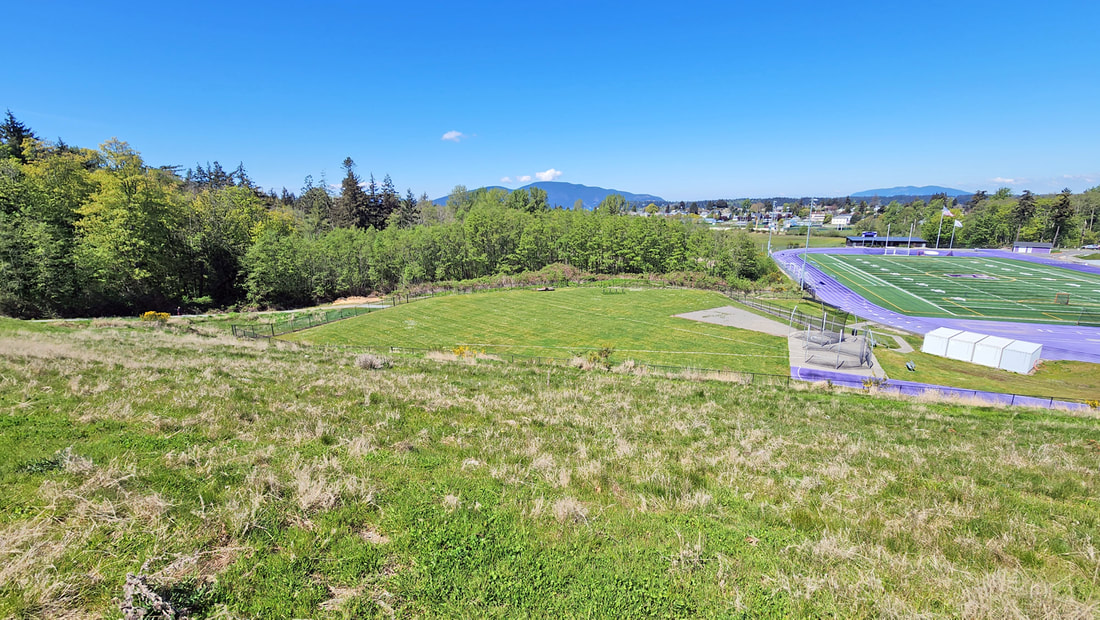 We hiked past the football stadium, down to the soccer fields of lawn grass, then back along the edge of the wetlands, once again teeming with the songs of critters in the key of life. jack “Action on behalf of life transforms. As we work to heal the earth, the earth heals us.” ― Robin Wall Kimmerer, Braiding Sweetgrass Directions: From 12th Street and Commercial in downtown Anacortes, go west one mile to G Avenue. Go left two blocks to the parking lot for Volunteer Park. The wetland trail starts at the south end of the ball fields.
By Bus: Skagit Transit serves this area with a bus route that leaves from 10th Street and R Avenue, arriving at 12th Street and G Avenue shortly thereafter. By Bike: The roads in this area are relatively flat. Twelfth Street is busy with narrow shoulders. Use side roads to avoid the traffic. Mobility: The pathways around the ballparks are mostly paved and flat. The trail through the wetlands is wide, firmly graveled, with very few obstacles, but it does gain elevation when you leave the wetland area. An out and back route is easier than the loop route. |
Authors
Maribeth Crandell has been a hiking guide in the Pacific NW for over 20 years. She's lived on Whidbey and Fidalgo Island for decades. As a frequent bus rider she easily makes connections between trails and transit. Archives by date
May 2024
Categories
All
|


 RSS Feed
