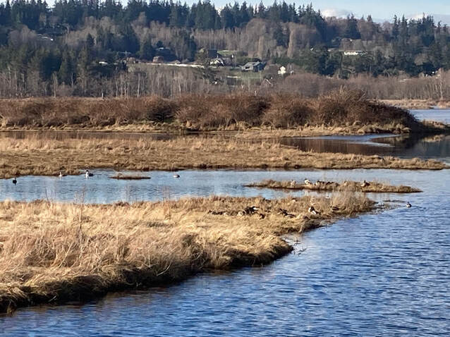
 Deer Lagoon is a popular spot with dog walkers, bike riders, strollers and joggers. But it’s really popular with birds and bird watchers. When I first moved to Whidbey in the late 1970s it was popular with duck hunters. Now it’s protected. In fact, it’s an official Important Bird Area, listed on the National Audubon website. The estuarine habitat, where fresh water and salt water mix, the small islands for nesting, the mud, the sand, the bay, the shrubby shore and nearby trees all make great habitat for waterfowl, shorebirds, songbirds, eagles and osprey. Walkers here often carry spotting scopes, binoculars and long lens cameras. But I was hesitant to include it in our book, Hiking Close to Home, because parking is limited and each access is adorned with signs saying, "No Trespassing" and "Private Property". Still, it’s commonly used by the locals. I scratched my head and tried to figure out where the property lines were and what might be open to the public. Were the signs there to protect private property owners from liability? I asked my friend Libby, an avid birder and a realtor who lives nearby. While we spoke on the phone I looked at the County website and saw the property lines that surround Deer Lagoon. Some extended far up the trail. So we cross private property to get to this amazing bird sanctuary. She said we can use the trail as long as we don't abuse the trail, or the homes nearby. Such a deal! Last Saturday was cold and clear. Jack was visiting so we bundled up and went to Deer Lagoon for a walk. He brought his camera. I brought my binoculars. We started our walk from the end of Deer Lagoon Road, passed the Private Property sign and entered through the trees. Double Bluff loomed large in the distance. Kinglets twitted and chirped. Red winged blackbirds called, “Mukilteeeeeo!” Out in the open I pulled out my binoculars. We strolled the dike southward into the sun stopping often to study the birds. We both tried to identify the ducks. Wigeons laughed at us. “That’s a mallard you bufflehead!” It wasn’t easy to identify a pintail with its head under water and its long tail bent over. We’re novice birders compared to the Audubon members who come daily. We noticed a Pacific wren darting among the shrubs on shore. Clouds of shorebirds cut across the bright blue sky flashing white and disappearing in an instant, turning and flashing white as they zipped past again. In recent summers flocks of white pelicans gathered at Deer Lagoon. I noted there were people strolling, a young family rode bikes, a woman jogged, some walked together six feet apart, couples walked side by side. The trail had a channel to the left where a lone duck swam getting a little “me time”. On the other side the lagoon stretched westward full of waterfowl. Houses ringed the distant perimeter. At the far end of the dike, just before the next Private Property sign, we took a narrow trail to the left that dropped down to a low area and crossed to the other side. We stepped up to the dike on the east side and headed north with a great view of the beach. We met a few others on the trail. All stepped around each other with masks up, passing safely and greeting each other warmly. It looks like a great place to live, especially if you're a duck. Directions: Take Highway 525 a half mile south of Freeland and turn south on Double Bluff Road. Drive another half mile to Millman Road and turn left. Drive another half mile to Deer Lagoon Road and turn right. Park at the end of the road being careful not to block anyone's driveway. Be respectful of Private Property as you enter the trail to the south.
This trail is within a mile and a half of the fare free Island Transit Route 1 bus and could be reached with the help of a bicycle. 1-2 bikes fit on a bus bike rack. It may be accessible to those who use mobility devices if they can maneuver through the entry area at the trailhead where it may require some assistance. The trail on the dike is flat, wide and hard packed dirt.
0 Comments
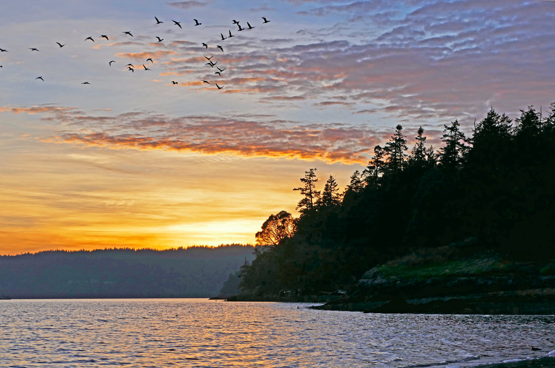 Storms have been raging around us: a pandemic, political divides, failing finances, racism, disunity and violence; and they rattle the walls of our individual lives, with stress at work, struggles at home, relationships shifting, community culture curtailed, norms shattered -- and it rages on. You know this. I know it too, as the storms batter us with a ferocious fury and intensity not seen before in our lifetime. “That even as we grieved, we grew, That even as we hurt, we hoped, That even as we tired, we tried, That we’ll forever be tied together…” A winter storm blew over our islands last week -- hard hitting, powerful punches that rolled over our coastlines and into our forests, the winds of a decade, someone said. And the decade is barely three weeks old. This wild westerly wind kicked over trees that were centuries old, bringing them to their knees in a random assault that lasted the whole night through. Several fell on Kiket Island, falling to the east or northeast from where they once stood. “We did not feel prepared to be the heirs of such a terrifying hour, But within it we found the power To author a new chapter, to offer hope and laughter, To ourselves sow. While once we asked: How could we possibly prevail over catastrophe? Now we assert: How could catastrophe possibly prevail over us? We will not march back to what was, but move to what shall be, A country that is bruised but whole, benevolent but bold, fierce and free.” I hiked onto the island a few days later. The air was calm, warm, and inviting; the waves gentle, a serene scene in contrast to the tumbled-down timber across the trails. Cars in the parking lot overflowed onto the street, parking safely on the shoulder, lining Snee-Oosh for a hundred yards. From here, the trail leads down to what used to be a causeway above the tides; now the highest of tides wash across the isthmus, leaving behind a wrack line of driftwood and seaweed. Seeing this beach restored to its natural beauty thrills me every time I see it. I hiked the North Trail as I headed west, aghast at the handful of trees down, but also marveling at the 99.9% still standing against such an onslaught, bending as needed, yielding to the push but unyielding to its power. Let it pass, and let it move on. We remain, and rebuild, new seeds already ready to grow in the new openings in the woods. “Somehow we’ve weathered and witnessed a nation that isn’t broken but simply unfinished.” On the western end, a mother and child played in the sand. An older couple hiked out on the beach to the far point, to see the view of the bridge. Driftwood covered the beach trail, but the low tide became a new trail as a pleasant plan B. The sun beamed warmly on us all. Two eagles called to each other; oystercatchers scolded me from a safe distance; a chainsaw echoed across the bay as a homeowner cleared his land of the storm’s damage; a motorboat cruised the waters near the bridge. The battery on my camera died. But no matter; my senses recorded the scenes and stories on the emulsion sheet of my mind and emotions. I was blessed to be here, to see life, to see rebirth. In the air I could smell the scent, the wish, the surety and audacity of hope reborn, returning in a new wave, the storm’s rage a fading memory. There is work to be done now: restoration, cleansing, sowing the seeds of life and unity. “When day comes we step out of the shade, aflame and unafraid. The new dawn blooms as we free it. For there is always light if only we’re brave enough to see it, If only we’re brave enough to be it.” jack with poetry excerpted from a poem written by Amanda Gorman, Poet Laureate of the United States, which she recited in full at the Inauguration of President Biden. Directions to Kukutali Preserve and Kiket Island:
From the Commercial Avenue roundabout in Anacortes, drive just under two miles east on Highway 20, and turn south on Reservation Road. Drive 1.5 miles south to Snee-Oosh Road which angles to the right. Continue for 1.3 miles to the park entrance on the right. Parking is limited. If full, you may park on the shoulder if you are off the fogline. Transit Options: Not available. Mobility Accessibility: The main trail across Kiket Island is packed gravel, and relatively accessible for wheelchairs from the parking area to the entrance to the first tombolo, although the graveled road/pathway is somewhat steep. There is a gate with adequate clearance to get around but uneven slopes and gravel in the bypass. There are also some relatively steep slopes in-between the first beach crossing and the west end of the island. The first beach crossing has loose sand, gravel and driftwood. The west beach requires considerable scrambling to get onto the beach. The restrooms at both ends are ADA, and there is one ADA parking stall. It had a car that did not have an ADA placard or license plate when I visited, however. Bummer. 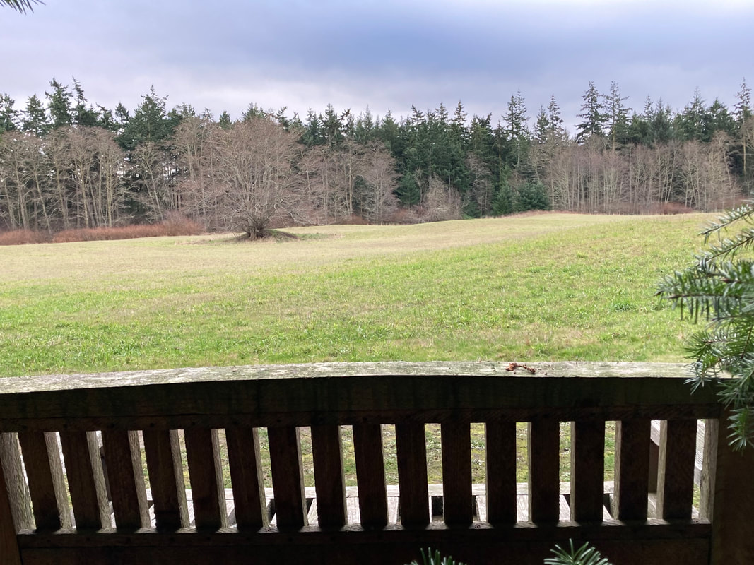 At this turning point in the calendar, we look forward and back. With all the turmoil and loss we’ve experienced in the last year, thoughts of death have been more on my mind. I lost my favorite uncle a few months ago. My elderly Dad told me last night that another close friend had died. The pandemic has taken so many. Most of us know someone. What do we do with the grief, sadness and pain? Doctor George Fairfax of Oak Harbor bought 50 acres of land in 1973 as an investment in the future. When his wife Del died, he donated it in her memory to the Whidbey Camano Land Trust. Investing in the future can take many forms: a 401K, teaching a child to read, buying and maintaining a piece of land. After such an incredible week of political upheaval I sought out a place of peace. Taking a walk on a quiet Sunday morning put me at ease. The 1.2 mile trail at the Del Fairfax Preserve weaves gently through Douglas firs. The tiny trumpet of a Nuthatch announced my arrival in the forest. The reception committee made up of cheery golden crowned kinglets, chickadees and juncos escorted me down the trail. I stopped as I came to a wide open meadow and took it all in. The rolling green field surrounded by evergreens and willows beckoned. A gentle wind pushed a few gray clouds aside to reveal patches of blue. A hopeful sign. A promise, perhaps, of better things to come. I turned to circle the meadow noting the signs labeling the native plants I passed, spirea, salmonberry, snowberry, Indian plum, willow and rose. A flock of pine siskins swept the treetops. As I walked I noticed deer trails, hoof prints, antler rubbings and pellets. The previous summer I’d visited and seen tall grass, daisies and deer throughout. At the east end of the meadow I recognized a tree with old claw marks on it. I’d seen that tree a couple of years before when the claw marks were fresh. I’d taken a picture and sent it to a wildlife biologist friend asking, “Bear or Cat?” He asked how high it was, if there were any bite marks, and determined it was a bear. A week later there was an article in the paper, “Wandering Bear Spotted on Whidbey”. The bear wandered on but the claw marks remain. I know there are farms and homes all around this property, but it’s nice to know that wildlife can make a home here, too. Sitting on the south-facing bench looking over the meadow, I felt peaceful inside and prayed for this peace to flow outward to others. This walk was good medicine for me. I finished circling the field at an easy pace and then turned back down the forest path. As I was leaving the meadow I passed a young couple. A minute later an older couple walk by. And just before I reached the gate two women with a child and a dog passed me entering the preserve. I was glad to see others using the trail. It seems like a small treasure for the people nearby. A place of peace for any age, at any time, but especially in these times. I gave thanks for the Fairfax family and their investment in our future. The sky was clearing with hints of blue. https://www.wclt.org/projects/del-fairfax-preserve/ Directions: From Highway 20, 4.4 miles north of Coupeville, and 5 miles south of Oak Harbor, turn north on Zylstra Road and drive 3 miles to the Fire Station. Please park alongside the fence and keep fire lanes clear.
This trail is not accessible for a wheelchair or mobility device and is not on a bus route. 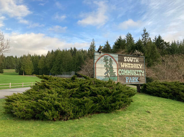 Last Sunday, I came up for air between storms and met my friend, Lee and her dog, Piper at South Whidbey Community Park. I’ve walked these trails in spring, summer and fall, but I wanted to see how they fared in the winter. Would there be trees down? Branches littering the trail? Pond sized puddles? I was surprised after all the wind and rain we’ve had lately that the answer was… none of the above. We parked across from the socially distanced shrubs and met at the trailhead to take a look at the map. Then we headed off on the smooth, wide, packed gravel paths that weave and loop through the forest. We spent a good hour exploring well marked trails among fir, cedar and alder groves and nary a puddle appeared. What struck me on this walk is the community in this Community Park. We passed dog walkers and joggers. Others walked briskly chatting in groups. We took the Connector Trail toward the sports complex on Langley Road and came upon a lively soccer game. Just beyond them a mother pushed her toddler on a swing while another child climbed into a little fort in the playground. Teenagers filled the skateboard park and other kids rode bikes. This park has something for every age or activity level. Walking back toward the High School we soon met Lori, a teacher and friend who told us she walks here almost daily. “It’s on my way home from work,” she said. Another woman came up jogging and stopped nearby. “New Year’s Resolution?” I asked. She smiled and said, “I come here every day.” I began to see a trend. Near the end of our walk we came upon Mark, Wendy and their dog Daisy. Dog walkers get four times more exercise than the average American adult. I used to refer to my dog as my personal trainer. I’d heard a podcast the day before, about forming habits. This time of year some of us make New Year’s Resolutions. We struggle to cut back the calories we packed in over the holidays. We vow to get more exercise. Studies show that we can't rely on will power alone. They say if you want to form a new habit, a healthy habit, there are some well tested strategies you can employ. Reduce the “friction”. For instance, if you want to go running first thing in the morning, you could wear your running clothes to bed. Couple something you don’t like to do with something you really enjoy, like listening to good music while taking a brisk walk. Set up your space so you link a new habit with one that’s already established. I put a five pound weight next to my electric toothbrush so while I brush my teeth with one hand, I lift the weight with the other. They say 40% of our behavior is automatic. So if we want to start a new habit we have to do it over and over until it becomes automatic. And if we want to unlearn a behavior, we have to make it something that requires our full attention, like eating with the non-dominant hand. That would slow me down. As we came to the end of our walk, I realized this was a daily routine, a habit, for a lot of those we’d met. Spring, summer, fall or winter, this park has miles of well-constructed, well-maintained trails that don’t puddle up and are clear of debris. So bring a friend, a dog, a skateboard or soccer ball, climb into the fort, try the swings, walk, or jog, at whatever pace you please. It’s a New Year. The light is returning. Let’s put our best feet, and paws, forward, between storms. Maribeth PS A week later I returned to SWCP and found flooding had occurred at the base of the Switchback Trail on the NW corner of the park. Speaking with a Park Commissioner, I was told this had started happening after a clear-cut on Maxwelton Road had changed the drainage in the area. There are still many trails that are accessible. Driving Directions:
From Highway 525 3.3 miles north of the Clinton Ferry or 3 miles south of the Goose Grocery at Bayview, turn north at Maxwelton Road, then turn right just past the High School. If you’re coming late in the day, you may want to park outside the gate on the north side of the High School so your car doesn’t get locked in at dusk. By Bus: Take the Route 60 bus, which goes between Bayview, Langley and the Ferry, and disembark at the High School on Maxwelton Road or at the Sports Complex on Langley Road. The park is between the two. *Or Take the Route 1 bus and disembark at the intersection with Hwy 525 and Maxwelton Road. Then walk north about a half mile to the northeast side of the High School. *Island Transit's fare free buses can carry two wheelchairs and two or three bikes. There are some hills and soft spots but wheelchairs or mobility scooters could use most of these trails with care. |
Authors
Maribeth Crandell has been a hiking guide in the Pacific NW for over 20 years. She's lived on Whidbey and Fidalgo Island for decades. As a frequent bus rider she easily makes connections between trails and transit. Archives by date
July 2024
Categories
All
|
 RSS Feed
