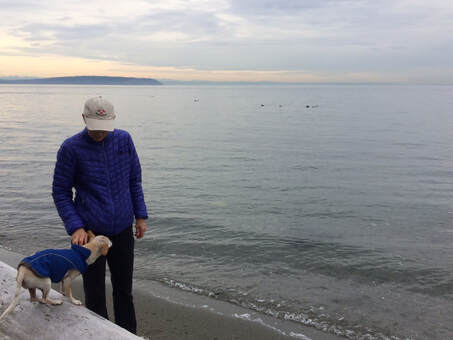
 Double your fun by walking with friends, both two legged and four legged, at Double Bluff. The entrance is busy with dog walkers and their canine companions enjoying the freedom of an off-leash dog park with sticks galore and water for splashing and sand for rolling around in. A short walk for humans makes a good run for dogs. There are restrooms, picnic tables, benches, pet poop bags and a dog watering station at the start. There are lots of materials for young architects to build forts and sandcastles any time of year. Walk farther to find a wilder less populated beach. Pick a calm day and take binoculars to spot loons, scoters, seals, sea lions and passing ships as you walk. Eagles often soar just overhead. This south facing bluff radiates warmth on a sunny day. During winter storms the bluff gets hit hard with wind and rain. Look up to see the bluff sluffing and slowly sliding toward the beach below. If the tide is out you could walk for miles out and back along this beach. On our walk the tide crept in until we could go no farther. If you want to start the New Year off right, join Stinger Anderson, WSU Beach Clean-up Coordinator, here on January 2 from 1:30-3:30. He will bring gloves and bags. You bring the energy and enthusiasm. For details visit: extension.wsu.edu/island/nrs/beachlitter/ If Double Bluff is too far away for you, check out upcoming efforts scheduled at Keystone Spit, Ebey's Landing and Joseph Whidbey State Park. Email Stinger to RSVP at: [email protected] Another great way to start the New Year is to take a First Hike at either Fort Casey State Park from 1:00-2:00 or Deception Pass State Park at 10:00 at the West Beach shelter. Knowledgeable volunteers will be leading these walks. No parking pass is required in any Washington State Park on January 1st. (Island Transit will not be operating on January 1st but you can get to both of these parks when the buses are running.) I always thought I should do on New Year's Day whatever I want to do for the rest of the year. My list is to sing, hike, write, eat well, learn something new, be kind, put some positive energy into my surroundings, appreciate the beauty around me and spend time with those I love. Here's wishing all of you a Happy New Year! Directions:
From Hwy 525 just south of Freeland, take Double Bluff Road south to the end. On nice days the small parking area may fill and cars may be parked along the road. Watch for pedestrians walking to and from their cars.
0 Comments
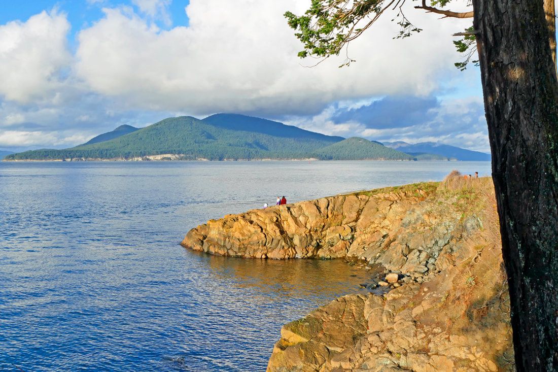 Hiking the trails of Washington Park in Anacortes gives such a richer experience than driving or even biking the paved loop route. At the speed of feet, the park reveals such depth, such variety, and such beauty around every turn. I started out mid-afternoon with wild mid-December weather, filled with storms and sunshine, towering banks of clouds and brilliantly blue skies. My goal was to hike the entire park staying on the water side of the paved loop road. Hiking a few yards west of the road as I journeyed counterclockwise from the boat launch area, the trail was narrower than the width of my body, which meant the wet salal leaves washed my jeans with every step I took. I found pocket beaches I had never seen before, and views of Cypress Island framed by firs. For a very short stretch I had to walk the edge of the loop road where the trail peters out at a rock face. But then I found Green Meadow, alive with kids and dogs and sunshine. The trail above the rocky shoreline leads to West Beach, where a man had bird seed in his hand, and nuthatches and chickadees eating out of his hand! Walking further south and west, I could now avoid the roadway area entirely by staying on the confusing array of trails that head south to the meadows. I found trail 501 and followed that through grasses, madrone, and juniper, their berries littering the ground like marbles. Here the soil is shallow, and hot and dry in the summer, making for a challenging habitat for life but expansive views out over the Salish Sea. The sun sank behind a large bank of clouds just above the horizon, and I was only halfway. I dropped down to trail 502 to be as close to Burrows Channel as I could, which led me east to the private Cabana on Skyline property. Then I clambered back up to trail 501 as the forest darkened and the temperature dropped rapidly. This trail eventually led me through alder and fir forests back to the park entrance, just in time for a sunset reflecting off those cloud banks and a ferry cruising the waters beneath. Note to self: next time, give myself more time to linger around the southwest corner of the park, where the land and sea meet in spectacular fashion. I sense a return hike is in my plans for the near future. jack Directions: From Anacortes take 12th Street west, which becomes Oakes Avenue, and which becomes Sunset Avenue near the ferry terminal. Sunset Avenue takes you directly into the park. Accessible by Skagit Transit 410 bus from Sunset Avenue and Skyline Drive, a quarter mile from the park.
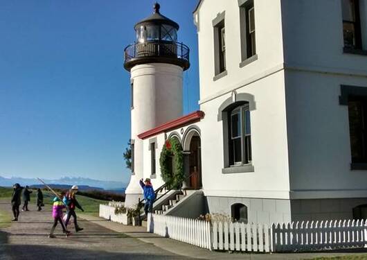 This picture of our local lighthouse was taken on a day in December. Another December. This month has been dark and dreary which is a good time to choose a walk in a place where you can get indoors if the day grows wetter and the wind grows colder. The Admiralty Head Lighthouse is a fine place to come in for a few minutes and study the displays, visit with the volunteers or shop for gifts or souvenirs. The lighthouse will be open from 11am to 4pm on Saturdays and Sundays this month and all week between Christmas and New Years. Then it will close for renovations for 8 months! There's a good selection of books, cards, mugs, toys, shirts and hats. Your purchases at the gift shop supports Lighthouse Environmental Programs. Before you go, climb the tower and count that as elevation gain. When the clouds part and the wind dies down, step out to continue your walk down to the fort with wide open views across the water to Port Townsend and the Olympic Peninsula. If you brought binoculars you can see Fort Worden and Fort Flagler that, together with Fort Casey, formed a triangular defense system to protect this gateway to Puget Sound back around 1900. The Fort will protect you from the winter wind and if the rain returns you can duck into the gun emplacements and read interpretive signs that tell the story of this fascinating place. Bring a flashlight to peer into the deep underground bunkers and test your singing voice. Or whisper into the speaking tubes that connect the gun decks above with the ammo storage rooms below. Climb the steep stairs and work your way around to the plotting rooms on top of the hill. Or, if you prefer, you may take the trail to the bluff or the beach and skirt the fort altogether. You could track the ferry, do some bird watching or maybe even see some marine mammals. If the tide is out you could walk east to the campground and then climb the hill up the winding road. When you reach the top, turn right and then left to enter the picnic area with views of Crockett Lake and Keystone Spit to the east. In the far corner is a glacial erratic covered in licorice fern. There's a trail that leads from the end of the picnic area through the woods and back to the lighthouse to complete your loop. This is a great place to explore with the extended family over the holidays. You'll need your Discover Pass if you drive, or you can purchase a day pass in the parking areas. Or take Island Transit right to the park entrance. Don't let a little winter weather keep you from a fun day of exploring. Directions:
Take Highway 20 to Coupeville and follow the signs to the Coupeville Ferry. Fort Casey State Park is just west of the ferry terminal. Bring your Discover Pass if you drive, or purchase a day pass in the parking area. Or take Island Transit Route 6 on weekdays or Route 1 on Saturdays. Call 360-678-7771 for assistance or check the bus schedule online: www.islandtransit.org/ 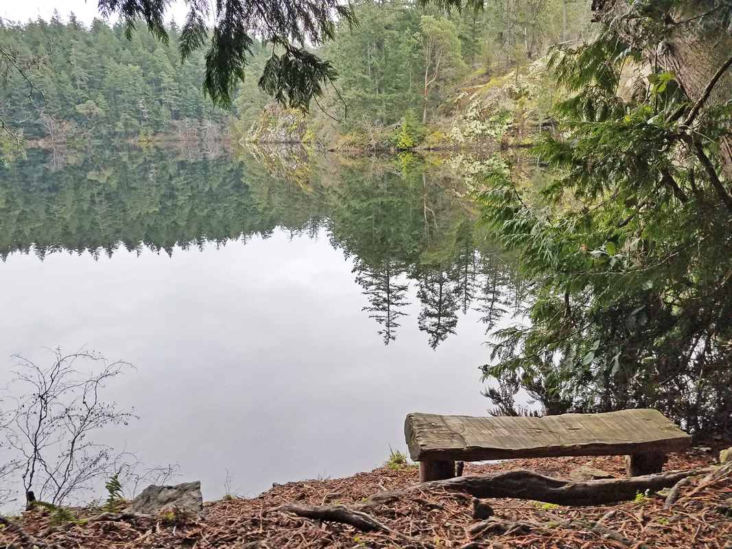 A wilderness hike in our backyard? A trail with great views and adventure around nearly every turn? I circumnavigated Whistle Lake this week and felt like I had been on a trail deep in the Cascades. I chose a gray afternoon with skies threatening to dampen my body if not my spirits. First, I was surprised to see that most of the road leading to Whistle Lake has now been paved for nearby residences. Only the last quarter mile or so is still dirt and potholes. After parking, I took Trail 20, a three-quarter mile dirt road overshadowed by towering firs and cedars, with an outhouse halfway to the lake. Then I took the west shore trail, Trail 204, which offers peeks at the lake from shoreline bedrock every few hundred feet. My goal was to keep turning left to stay as close to the lake as possible. The trail curves around to the west, with some viewpoint trails leading off the main trail to get to the lake’s edge. Then you must go north, away from the lake, to get around the far west wetland, turning left and following trail 21 west then turning left again on trail 22. After a quarter mile I turned left yet again, this time on trail 205, which ignores the lake somewhat but offers denser woods, more challenging terrain, and fascinating diversity. And a deep quiet. And a growing darkness. Evening was approaching, and the clouds were lowering. Trail 205 skirts the edge of Toot Swamp, a wetland with a memorable name, and leads to a wooden bridge crossing the small stream draining Whistle Lake southward. This looks like an old dam feature. Then the trail climbs eastward. A short trail leads north to the cliffs on the south side of Whistle Lake. Trail 205 becomes a writhing dragon, climbing, descending, squeezing through rocks, going north, going south, before it finally turns hard left to follow the eastern shore and heads back to the trailhead. I bolstered my strength with the remainder of a dark chocolate candy bar a friend had given me, and powered on. An owl glided silently over my head, a ghost in the gathering darkness. A light sprinkle began to splatter the lake. More vistas and access points along the lake opened up until I reached the popular northern shoreline, now silent in the dusk of evening. I walked back to the parking lot in the dark, a satisfying exploration of more than three miles of our backyard wilderness. jack Directions: Go south from the Commercial Avenue roundabout. Take a left at the T onto Fidalgo Avenue, left again on Hillcrest at the stop sign, and then right onto Whistle Lake Road. Follow the signs a couple miles. The road turns left at a small intersection. Follow that now-paved road until you see the sign for Whistle Lake leading down a dirt road to your right. You're almost there!
|
Authors
Maribeth Crandell has been a hiking guide in the Pacific NW for over 20 years. She's lived on Whidbey and Fidalgo Island for decades. As a frequent bus rider she easily makes connections between trails and transit. Archives by date
July 2024
Categories
All
|
 RSS Feed
