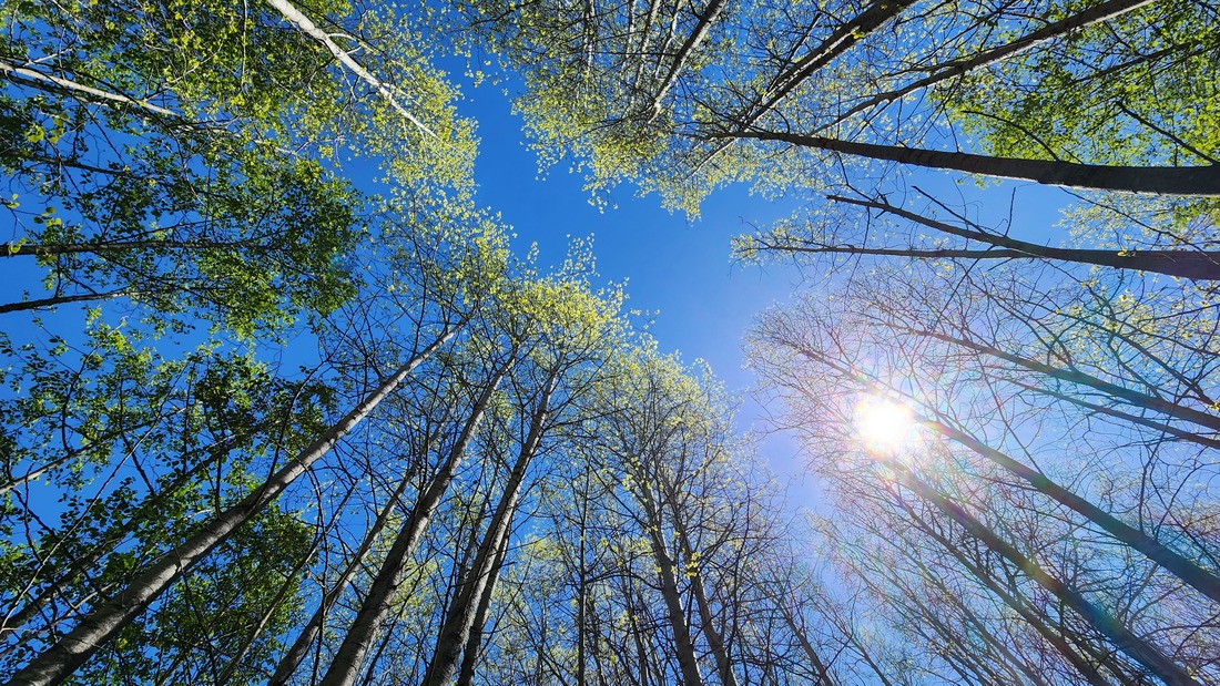
 “To love a place is not enough. We must find ways to heal it.” ― Robin Wall Kimmerer, Braiding Sweetgrass Once upon a time, there was a wetland surrounded by forests and beaches. The ponds hosted a diverse habitat of plants and wildlife that called it home for thousands of years. Tribal members lived on the beaches nearby. It’s an oft-repeated story: new people moved into the area, cutting down the forests for houses and stores, building factories on the beaches, and plowing wetlands into farms. This new town they called Anacortes. The town grew and grew. Houses multiplied, farms flourished. One farm in the lowlands below the high school was owned by a family named Smiley. Much of this farm had once been the wetlands. Eventually, some of the farm became playfields, and some of it grew back as forests and wetlands. All these lands became known as Smiley’s Bottom. Below: the farmland to the left of the second U in Museum is now the wetland and woods being restored at Smiley's Bottom. The farmland to the right of that line is now Volunteer Park's ballfields and playgrounds. Skyline and Washington Park are at the very top of the photo. 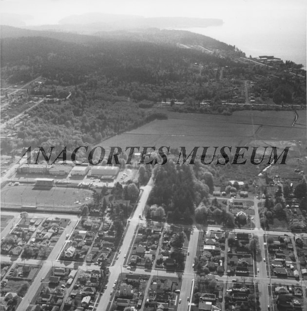 In recent years, the north end of Smiley’s Bottom became Volunteer Park, a collection of formal ballfields and grassy play areas. The east end is now a large open grass field used for lacrosse, football, and soccer. The south side is returning to its roots as a forest and wetland. As a hiding place close to the high school in the middle of the city, Smiley’s Bottom became a hangout for youth parties, vandalism, and garbage. Neighbors found a large fort built well off the beaten path, made with trees cut down from the nearby forest, with hundreds of beer bottles scattered around the party site. And neighbors noticed that the wetland, now protected by law, had park and school developments encroaching into the wetland. It became time to truly care for Smiley’s Bottom. School and Parks Department folks removed the fort and the stumps of trees that had been hacked down to make it. They hauled away beer bottles, fire pits, and old tires. Damage to the wetland was mitigated to begin the restoration of this precious and vital habitat. The trail through the wetlands and woods became formalized and modernized to allow trail use in all four seasons and to encourage public visitation. Kath and I walk these trails often. Here in the middle of town, beneath the hill of the high school, amid dense neighborhoods and sporting events of all kinds, Smiley’s Bottom is once again becoming a healthy wetland world of its own, a haven of habitat, a sanctuary for wildlife that still calls this place home. Today was Earth Day, 2024. The scent of cottonwoods filled the air as we walked to Smiley’s Bottom from Volunteer Park. Sunshine blazed, warming our hearts with the feeling of spring. Songbirds sang joyously – red-winged blackbirds in the tules, song sparrows in the alders, chickadees and even goldfinches in the canopies above. Ponds reflected the bright green of willow leaves, reeds, and grasses. Salmonberry flowers were changing into berries. Humongous skunk cabbage leaves rose out of muddy channels. Farther south we entered the hall of maples, the trail meandering through the wide open, drier forest just above the wetland. Ferns raised their fiddleheads to greet the spring. Pac wrens filled the airwaves with crystalline music. At the southeast corner, I climbed the hill next to the high school. From this vantage point, I could look north over what was – once upon a time – nothing but wetlands and woods; which became farms, and then houses, playfields, and a big city. At my feet, in Smiley’s Bottom, nature is returning. A redtail hawk glided overhead; insects buzzed; life flourished. The wetlands as seen today from west of the high school, looking north across Smiley's Bottom to Volunteer Park. Guemes Island and Lummi Island rise in the distance. 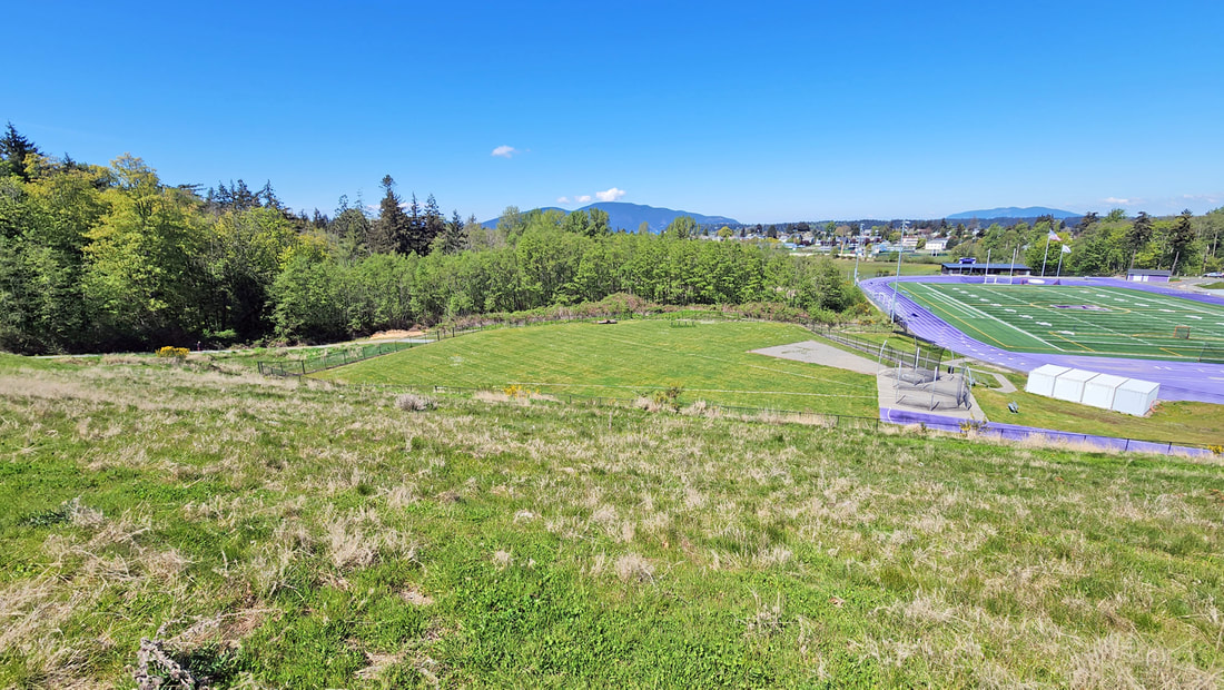 We hiked past the football stadium, down to the soccer fields of lawn grass, then back along the edge of the wetlands, once again teeming with the songs of critters in the key of life. jack “Action on behalf of life transforms. As we work to heal the earth, the earth heals us.” ― Robin Wall Kimmerer, Braiding Sweetgrass Directions: From 12th Street and Commercial in downtown Anacortes, go west one mile to G Avenue. Go left two blocks to the parking lot for Volunteer Park. The wetland trail starts at the south end of the ball fields.
By Bus: Skagit Transit serves this area with a bus route that leaves from 10th Street and R Avenue, arriving at 12th Street and G Avenue shortly thereafter. By Bike: The roads in this area are relatively flat. Twelfth Street is busy with narrow shoulders. Use side roads to avoid the traffic. Mobility: The pathways around the ballparks are mostly paved and flat. The trail through the wetlands is wide, firmly graveled, with very few obstacles, but it does gain elevation when you leave the wetland area. An out and back route is easier than the loop route.
0 Comments
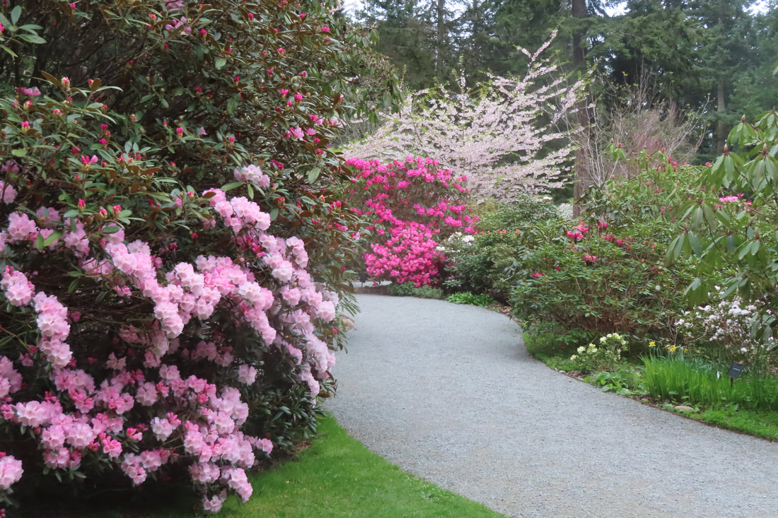 “Leave a place better than you found it.” That’s what my mom always said before leaving our campsite. My folks took us all over the country exploring the natural wonders of 45 states. We were five small kids spilling out of a station wagon, a terrifying sight at any campground, but mom had us well trained and organized. Everyone had a job, getting water, gathering firewood, setting up our camp kitchen and washing station. My favorite job was finding a centerpiece to adorn our picnic table. It could be a special rock, a shell, a cone or a feather. No matter how small, mom would make a big deal out of it. It became a conversation starter at dinner. In the morning, after we packed up and were ready to go, we'd circle around the campsite to look for litter, even if WE didn’t drop it. “Leave a place better than you found it,” she’d say. Words to live by. It's great to live in a community of folks who are doing just that. Volunteers work on trails, restorations projects and pick-up litter on a regular basis. You may be one yourself. One couple dreamed of creating a woodland garden. They started back in the 1960s installing rhododendrons, azaleas, flowering trees, even giant Sequoias on their wooded property near Greenbank. They had a special interest in hybridizing rhodies and collecting interesting specimens from around the world. They worked for decades to make their vision a reality. Ann and Max Meerkerk certainly left this place better than they found it. Now it’s maintained with help from volunteers. And the public can visit for a $10 entry fee. I met a friend at Meerkerk Gardens on a cloudy afternoon. It seemed quiet and almost secretive as we passed through the stone gatehouse. Red rhodies bloomed on one side and a pallet of blossoms greeted us on the other. Pastel pinks and purples drew us along the gravel path. The deep greens of tall conifer branches sheltered the colorful flowers and shrubs below. My initial impression was one of peace and awe. As we moved along, I began to notice the small things which tickled me with delight. The last of the golden daffodils hovered above a cloud of blue forget-me-nots. We passed a grove of flowering trees with a constellation of flowers shimmering in a sea of green beneath them. On one path, a council of well pruned shrubs seemed to lean in whispering. In the Secret Garden a fairy sat on a toadstool, a gnome stood on a swing and a stone sparrow splashed in a bird bath filled with flower petals. We wandered by the plant nursery to the gazebo and enjoyed the view across the water. I recalled being here for the fall festival and Mother’s Day events when there was live music, picnicking and plant sales. On this quiet visit the concert was offered by chickadees, juncos and kinglets. We took the trail down toward the ponds and then crossed over to the nature trails. The half mile woodland loop led us by old fire scared stumps, nurse logs and the more subtle forest flowers of pink salmonberry, yellow skunk cabbage and trillium's pearly white petals. Returning to the ponds we wandered between huge rhodies with fluffy white petticoat blossoms. Bees buzzed between them. This woodland garden is inviting for people and wildlife. A chestnut backed chickadee called from a branch just over my shoulder and asked me to take a picture. I was happy to oblige. We all do things to “leave a place better than we found it”. In April, during Whidbey’s Earth and Ocean Month, there are dozens of opportunities to join a crew for trail work, restoration projects or picking up beach litter. For details on walks, talks, special events and volunteer projects, click here. Peak Bloom Season tours at Meerkerk Gardens, 1:00-2:00 Saturday, April 20. Mother's Day Event May 12th. For more about Meerkerk Gardens click here. Directions: Take Highway 525 to Resort Road, 2.3 miles south of the Greenbank store. Turn east onto Resort Road and in a half mile turn north on Meerkerk Lane.
By Bus or Bike: Take the Island Transit Route 1 bus on the highway to Resort Road. (The Route 1 bus sometimes goes down Smuggler’s Cove Road instead of the highway, so make sure you take one that will travel on the highway by Resort Road.) Here's the bus schedule. Walk a half mile east to Meerkerk Lane and turn north. The Gardens are a short walk farther. Two bikes fit on a bus bike rack. Resort Road and Meerkerk Lane are quiet roads, but there is no shoulder so please wear something bright while riding or walking on the road or flagging down the bus. Mobility: The gardens have well-groomed, almost level paths of packed gravel. The woodland loop trails are more narrow. There’s a short, steep hill between the gardens and the woodland trails. 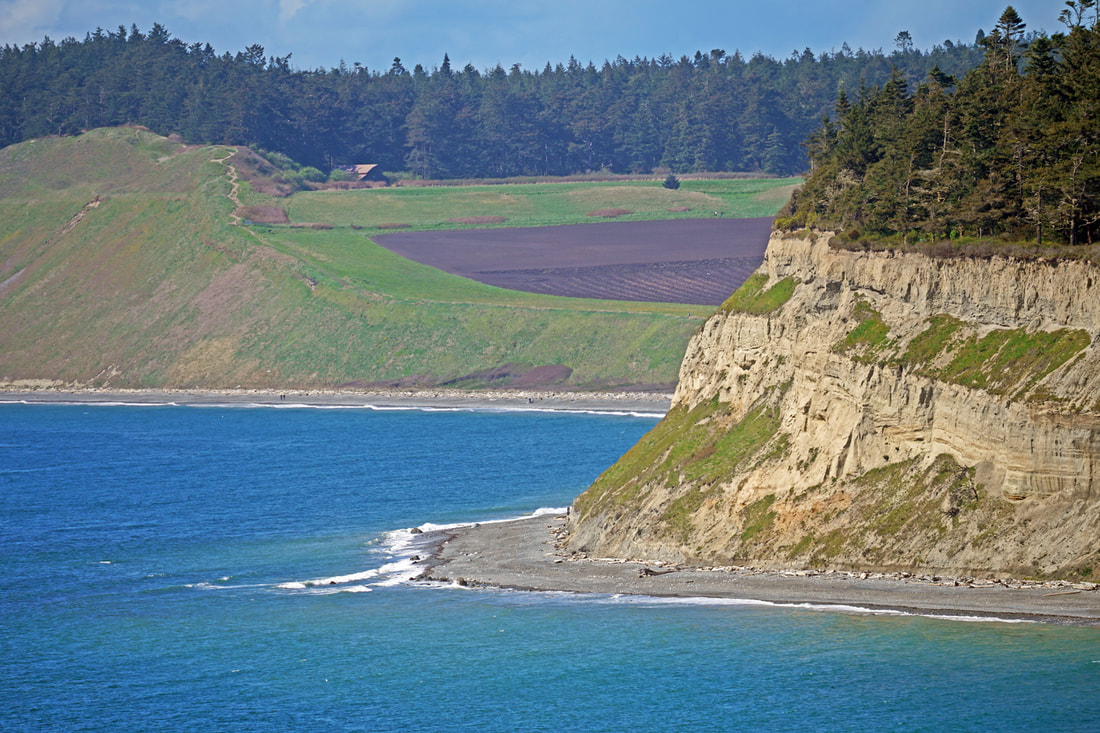 Just $40,000. When the Army declared Fort Casey to be surplus, Seattle Pacific College recognized the site's potential to become a center for educational and recreational activity. They purchased the northern half of the fort in 1956. This area, now called Camp Casey, included officers' houses, soldiers' barracks, dining facilities, an auditorium, and a gymnasium. Skeptics called the purchase "Watson's Folly”, mocking the decision of the college’s president, C. Hoyt Watson. The total price he paid for this low-bank waterfront property on Whidbey Island – just $40,000. Add three more zeroes for its value in today’s market. Looking at Google Maps, I saw a fort battery just north of the buildings, hidden in the woods. Storm clouds were breaking up, the promise of a sunny day coming our way. “Let’s go check it out,” I said to Kath. And while we’re there, let’s walk into the Admiralty Inlet Preserve just north of it. “Sounds good!” she said. Being privately owned, drop-in visitors are required to register to walk the property. We stopped at the office, open 8 – 5 on weekdays, and met Jake, who greeted us warmly and had us sign the guest register. We were the first registered hikers in nearly two weeks. What a treat people are missing out on. We followed the sidewalk north between the fort buildings until the sidewalk became a dirt road going uphill. At the top, the road swung west – and there it was, a two-turret gun emplacement, the view becoming overgrown but the structure still intact. Walking further north, it wasn’t long before we came to a turnstile gate, the entrance to the Admiralty Inlet Preserve, right next door to Camp Casey! A trail loops around the Preserve, providing a three-mile loop to explore. Jointly owned by the Department of Natural Resources and Whidbey Camano Land Trust, the 86-acre property is permanently protected and will remain forever wild. Picture centuries-old windswept Douglas firs along the bluff edge, multi-storied forests behind them, the wind whispering in the treetops, a chorus of birds harmonizing with their sweet voices, the sunlight dappled on the dark earthen trail, the spring air fresh and fragrant. Around every corner is a new delight: a fir with octopus arms raised to the sky, salmonberries in full flower, a chipmunk feeding in a rosebush, an orange-crowned warbler dancing from red alder to blueberry elder. 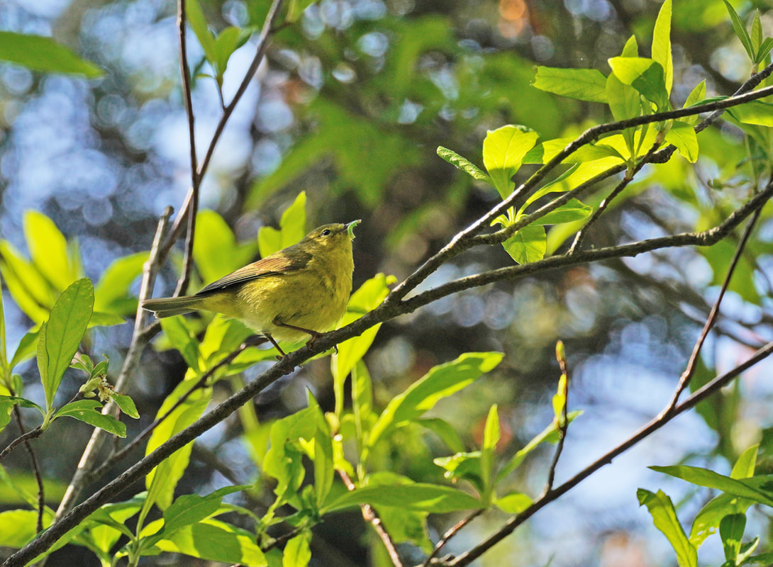 And then the view drops away in front of us, stunning in its drama of headlands and beaches stretching for miles. 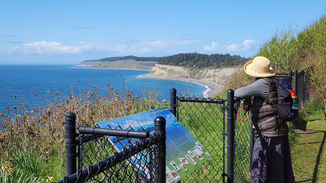 Eventually, we came to green prairies spreading before us, just now springing forth with the diversity of what once covered swaths of the Whidbey Island countryside. The two prairies (less than one percent of Whidbey Island’s original prairies remain) are home to a population of golden paintbrush, two of only twelve sites in the world where this endangered prairie plant occurs naturally. The trail then leads to a parking area across the highway. We turned around here, and followed our footsteps back, hugging the prairies, the bluffs, the views, the windy woods, the wildlife chatter, the warmth of spring, and the joy of being alive in this time and place protected and available for us all. Wandering back to Camp Casey, we strolled westward past the officers’ houses to where the sidewalk ended at the beach. Waves rolled in from last night’s storm. Seagulls, eagles, and hawks were hang-gliding above the bluffs in the onshore breeze. The officers’ houses watched in silence. Just $40,000. Priceless. jack Directions: From Highway 20 in Coupeville take Main Street south, which turns into South Engle Road. Turn into the camp at the north end of the large mowed grass field. Park near the office and sign in, or call ahead to make sure you can visit.
There is also a parking area for the Admiralty Inlet Preserve at the north end of the Reserve before S. Engle Road starts to drop down to Fort Casey. From this parking area, you can also walk to Rhododendron County Park 3.5 miles to the east. Or travel 1.5 miles to the Prairie Wayside to the north. The trail crosses Land Trust-protected conservation easements. These working farmland properties are privately owned so be respectful as you travel the trails. By Bus: This entire area is accessible by Island Transit. By bike: There are many side roads around the Fort Casey area that are delightful for biking; roadways are narrow, so watch your mirrors, and there are ups and downs. Mobility: The sidewalks at Camp Casey are mostly flat and mostly in good shape, until they end. The roadways are rough. The trails are well maintained, but narrow in places and with tree roots. There is considerable slope at times. 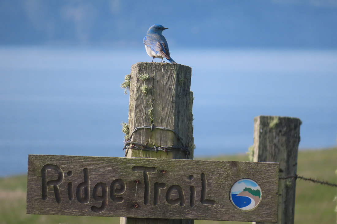 It was April Fool’s Day, but I fooled them all! I rode with the commuters to Coupeville but I didn’t go to work! No! Not on such a beautiful, sunny, spring morning as this! From the Sherman Road bus stop, I took the winding Kettles bike path a short ways. At the edge of the cow pasture, where the trees fill in, I turned onto the Kettle’s Spur trail toward the Pratt Loop. It was early, the sun just up. Birds called all around, but the shrubbery was thick and flutterings were many. Out of sight beyond the hedge, a cow lulled. Curious. A fir tree with a tiny window tucked among the bark. A fairy sat quietly beside it. Below, was a door with a walkway of fairy dust leading to it. More sprites around the base paused to stare up at me. A cheerful greeting passed between us. I moved on passing benches, hidden in a tunnel of Ocean Spray at the edge of the woods, at the edge of the pasture at the edge of the day. Approaching the barn was the strong smell of nettles, growing green and vigorous, out of winter’s duff. Birds were busy in the boughs overhead. I stopped to look and listen. Chickadees, Pine Siskins, and a Junco called out its warning. I slowly circled the barn hearing a steady chipping on a hollow tree. There! High up was a flicker, working to enlarge a hole. It poked its head in, withdrew, pecked some more, checked inside, and chipped some more. Another home improvement project. Passing a bench, I entered a stretch with a head high hedge on each side, like a formal garden. Sun poured in and I paused to let it warm my face. But a hummingbird buzzed me, just missing my head, defending its nest. I looked around for it and was buzzed again. Okay! Okay! I moved on. Around the next bend the Ocean Spray and elderberry grew thick among trees. Chirping, calling, singing birds ducked in and out. A nuthatch hid among the shrubbery. A song sparrow called from the field. A mob of bush tits flitted from one shrub to another. A Great Horned Owl called in the distance, a towhee cried up close, and a yellow rumped warbler, a spring migrant, sang from the trees above. I turned in circles trying to get a good look. A few more steps and there was a brown creeper, spiraling, inspecting a fir for insects. Below the branches I could see the cabin across the field and soon I emerged from the woods and stood in the open gazing over Ebey’s Prairie, Admiralty Inlet and the Olympics peeking through the morning clouds. Hundreds of acres of farmland dotted with barns and houses, fence lines and roads framed in by the water and mountains. And people. I hadn’t seen any on my walk through the woods but here in the open I could see hikers in small groups heading up the bluff or crossing the ridge trail. I circled the field hearing savanna, golden crowned and white crowned sparrows. Turning toward the Ebey cabin a bird on a fence post caught my eye. Was it a House Finch, or a Purple Finch? I walked on passing a few ladies chatting energetically. At the cabin I sat on the bench and took out my thermos. Quail called in the hedgerow. Red wing blackbirds sang, "MukilTEO! MukilTEO!" An eagle sat silently at the top of the tree next to the cabin. Hikers approached moving briskly. As they passed I noticed a small bird on the trail sign. Raising my binoculars, was it… a bluebird? Perfect. Maribeth “and over our heads will float the Blue Bird singing of beautiful and impossible things, of things that are lovely and that never happened, of things that are not and that should be.” Oscar Wilde Directions: If not on the bus, the Pratt Loop Trail shares a parking lot with the Ebey's Bluff Trail. Take Hwy 20 just north of Coupeville and turn south on to Sherman Road. Turn right at Cemetery Road and drive cautiously to the very end. Park by the Ebey's Landing National Historic Reserve offices and start north just behind the cemetery. When you reach the barn you may turn right to take the Spur Trail or left to continue around the loop. The Pratt Loop meets the trail to Ebey's Bluff near the Jacob and Sarah Ebey cabin.
By Bus and Bike: Take the fare free Route 1 bus to Sherman Road. Take the Kettle's bike path north west and turn left onto the Kettle Spur trail at the edge of the forest. Look for the short sign post. Park your bike at the kiosk where there is a bike rack. Two bikes fit on a bus bike rack. The Kettles bike path is paved but hilly in this section. It starts at Rhododendron Park south of Coupeville and continues to the Kettles Trails and Fort Ebey State Park trails north to Libbey Road. These trails are very popular with mountain bikers. Mobility: This is a nearly flat, well maintained trail with few roots or rocks. Part of the way is on old farm roads. The Pratt Loop is 1.3 miles and the Kettles Spur Trail is 3/4 of a mile long. |
Authors
Maribeth Crandell has been a hiking guide in the Pacific NW for over 20 years. She's lived on Whidbey and Fidalgo Island for decades. As a frequent bus rider she easily makes connections between trails and transit. Archives by date
July 2024
Categories
All
|
 RSS Feed
