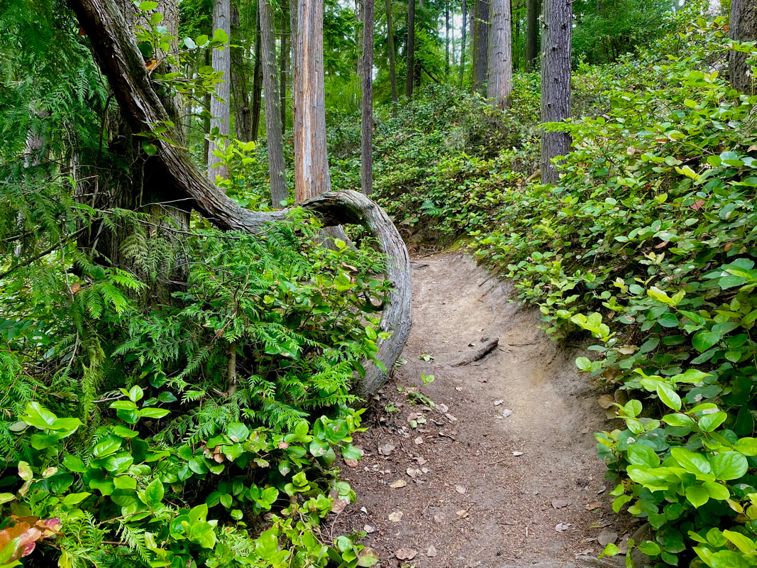
 Very cool! Island Transit has a new bus route that can take hikers right into Fort Ebey State Park, Fort Casey State Park and to the Ebey’s Landing trailhead to the Ebey’s Bluff Trail. But it’s only for the summer and not many know about it. So I decided to try it myself. Here’s what I learned. I caught the Route 1 Northbound from Freeland. As we neared Coupeville I told the driver I wanted to catch the Central Whidbey State Park bus. It’s a close connection between these buses at the Coupeville Park and Ride. The driver radioed ahead telling the next bus to wait for me. So tip number one, tell your bus driver where you want to go and they’ll help you get there. The next bus driver took me into Fort Ebey State Park. I asked to be let off at the entrance station, but told him to look for me at the Lake Pondilla parking lot when he came back in 90 minutes. Then I had to figure out how far I could hike in 90 minutes. I know how fast I walk on a sidewalk, but trails are slower. I take pictures, listen to birds, stop to enjoy flowers, and views of the water, and there are ups and downs, roots and rocks, etc. So I set out with a modest plan with options to add a short section if I had time at the end. I took the Old Gun Battery Road just up the hill from the entrance station, an easy walk passing the Hiker Biker campsite. The bus had turned down toward Lake Pondilla as I got off but here it was at the gun battery parking lot. I passed by and took the Bluff Trail looking into a thick fog bank, hearing buoy bells, fog horns and waves hit the beach below, but seeing only a white curtain. Turning into the forest the twisted trees told how hard the wind blows on the bluff. I circled the campground and took the Hokey-Ka-Dodo trail inland. Other trails presented themselves, but with a limited time, I stuck to my plan taking the Forest Run trail over to the Raiders Creek trail. That is my favorite trail in the park. It’s lush with a ravine on one side and a bank on the other. I walked flanked by sword ferns four feet high. As I reached the road, I crossed to take the Kyle’s Kettle Trail. A deer stepped out from behind a tree. A snag told of hungry woodpeckers hard at work. Several ravens were barking madly close together making a terrible raucous. A moment later I came upon some trees with scratch marks up over my head. Bear? Was that what the birds were so excited about? This park is plenty big to hide and feed a black bear. One had been seen on the north end a few weeks ago. I arrived at the Old Entrance Road and turned toward the lake. A few minutes later I was walking the narrow trail toward the water. Lily pads graced the surface. But I couldn’t linger. So I turned and climbed the hill to the Beach parking lot. No bus. I walked down to the end of the road around the corner. No bus. I walked up to the entrance station. No, Karen told me, the bus had left. It must have passed through my end of the park and gone up to the gun battery. So I went on another walk, found a spot in the sun to eat lunch, and then came out to the entrance station (which is also the exit station) to make sure I caught the next bus. I called Island Transit and the park staff to talk about it and they’d prefer we meet the bus at the Lake Pondilla or Beach parking area. But not all the drivers know this. It will take a while to work out the kinks. It’s cool to take a bus to a trailhead, but bring a lunch just in case. Maribeth To get the schedule for the Central Whidbey Parks bus click here. For a park trail map, ask at the entrance station. Directions: From Highway 20, 4 miles north of Coupeville, turn left on Libbey Road. Turn left on Hill Valley Drive which leads into the park.
By Bus and Bike: See the Island Transit bus route for the Central Whidbey State Parks here. Two bikes fit on a bus bike rack. Mountain biking is popular at this park and the adjoining Kettles Trails. Libbey Road is moderately traveled but there is no shoulder once you turn onto Hill Valley Road which twists and turns and is hilly so please wear something bright if you bike there. Be careful of RVers as you near the park. Mobility: The trail from the Beach parking area to Lake Pondilla is smooth and nearly level except at the end near the parking lot. The Old Entrance Road is smooth, almost level and wide with a small place to pull over where it meets the park road. Other trails are more challenging with roots, rocks, ups and downs. The gun battery is paved and level.
0 Comments
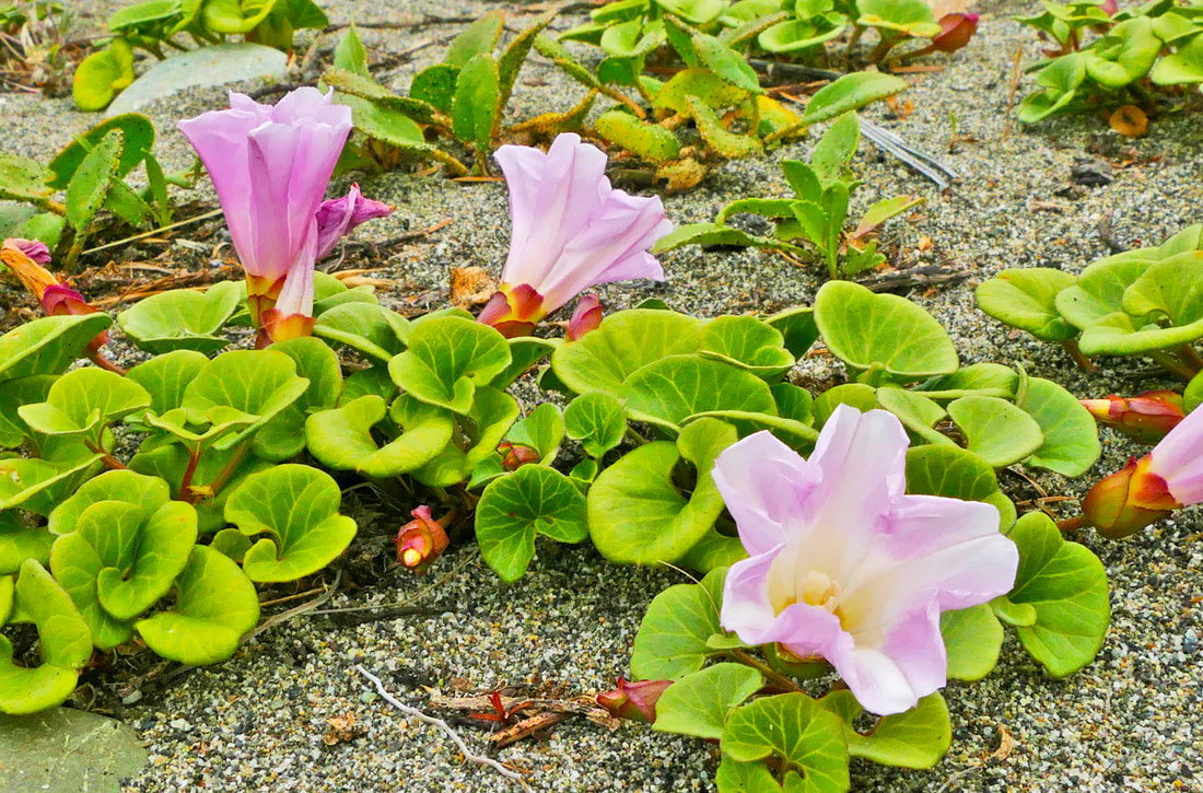 One hundred years ago this coming Saturday, a child was born who would become a beautiful, loving and giving human – my mother. Deception Pass State Park had been born just a year earlier, though as we all know, the land and its life have been here since time immemorial. Individual trees, flowers, critters, and others have come and gone, some here for just a few days, some a few centuries. Each leaves their legacy, their lives a foundation for the future. “We spend precious hours fearing the inevitable. It would be wise to use that time adoring our families, cherishing our friends, and living our lives.” -- Maya Angelou I chose to spend some morning hours at the Dunes Trail. This hike is oh so familiar to me, yet it is different each day, each hour. This is also a fragile area, where one off-trail footstep can disrupt dozens of lives. Today was as new as the dawn of eternity. The air was still, the lake still, the sea still. The islands around me stood quiet in their green fir coats. The distant Olympics poked their peaks above rolling clouds. It didn’t take long for my heart to join into that stillness, as I absorbed their peace, their acceptance every day of the life they have been given. The parking lot was nearly empty. A man sat alone in his car, taking in the view out over the straits to the San Juans, the Olympics, and even Japan were it not for the curve in the earth. Walking toward the dunes on the west trail, I found a couple familiar faces heading my way. We hadn’t seen each other since I retired, and we greeted with the comfort of old friends. They said they missed me, as I did them; here they were, still walking the trails nearly every day just like they have for decades. I then met up with an even older friend, one about 800 years old or so, give or take a century. This tree must have danced in delight as it grew; it never fails to make me smile and lighten my step as I look at its waving arms. Flowers bloomed nearby, rooted in grains of sand, soil as ephemeral as the next windstorm. Their beauty held nothing back, explosions of color displayed in their short-lived joy. At the south end of the trail, a boardwalk leads to the beach, which I had to take, of course. The only sounds were the surf and the seagulls, a seductive symphony that never grows old. I turned inland, walking among the forested groves, the waves quieter here, songbirds taking the lead. Salal and roses were in full bloom, light green growth on the yews and firs brightening the woods. Back at the lake, sunlight glowed through billows of clouds. “To the attentive eye, each moment of the year has its own beauty, … every hour, a picture which was never seen before, and which shall never be seen again.” ― Ralph Waldo Emerson The beach called again so I wandered north to the tidepools at West Point. Life is fragile here too, delicately balanced between the tides. Looking back through the parking lot, I saw once again the scene of so many of my work-life memories, and childhood memories as well. Looking back in time, it was my father who gave me my work and service ethic, and my mother who gave me my love ethic. She passed too soon from this life at the age of 68, leaving a hole in my adult life and the lives of her grandchildren and others. But she also left the legacy of her love, a blooming flower that never fades. “We are fragile creatures, and it is from this weakness, not despite it, that we discover the possibility of true joy.” -- Desmond Tutu Directions: From Highway 20 one mile south of the Deception Pass bridge, turn west into Deception Pass State Park. Follow signs to West Beach. Walk south. Or north.
by Bus: Take bus 411W from Oak Harbor or March's Point to the park entrance one mile south of the Deception Pass bridge. By Bike: Highway 20 in this area is hilly, very busy much of the day, and with narrow shoulders throughout much of route. Mobility: The Dunes Trail is paved and flat. 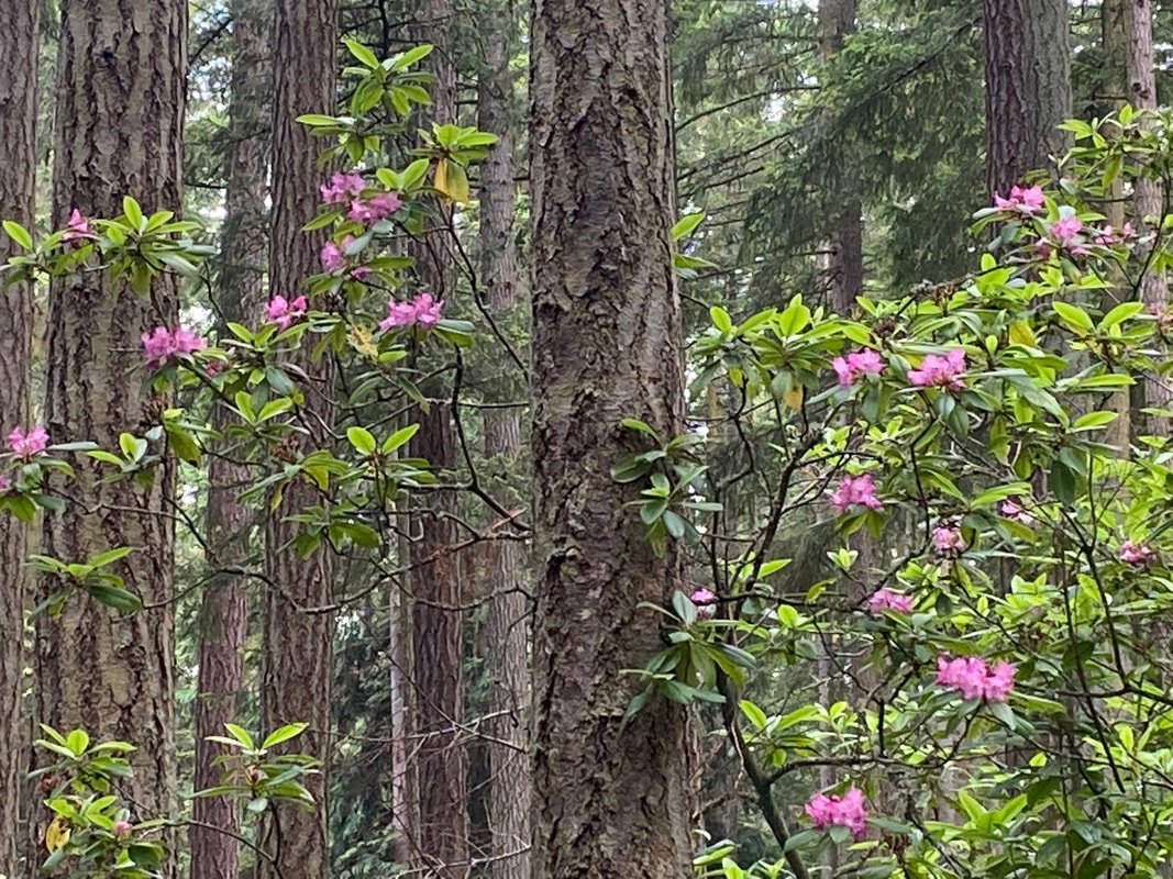 If you look at a map, it’s at the heart of Whidbey Island. And if you want to impress your sweetheart, you might bring them here. That’s what Vin Sherman told me while walking in Rhododendron Park last fall. He grew up on Ebey’s Prairie, just outside of Coupeville, and said on prom night, they’d cruise the Rhodie Road and see the wild rhododendrons in bloom, as pretty as the corsage they’d just pinned on their date. What a lovely image. I filed that away in my memory bank and this spring, I actually remembered to go see for myself. My yard has huge rhododendrons that erupted in full bloom this month. The largest could hide a house with purple flowers as big as a cheerleader’s pompoms. When people stop by, their eyes widen, they draw in their breath and praise the beauty thinking maybe I had something to do with it. I didn’t. These shrubs were planted here thirty years ago by Harold and Gerta. But I’ve been doing my best to maintain them. Walking through Rhododendron Park is totally different. These rhodies are native, growing among the tall fir and cedar in a natural forest. It took me awhile to adjust to their subtle beauty. A pale blossom spotlighted by a single ray of sunshine breaking through the canopy; a cluster of purple flowers reaching for the sky between tall trees. I’d hopped on the bus after work and hopped off at Quail Trail Lane, just across the street. I waited for the cars to part and then hustled across the highway to the Rhododendron Bike Trail for easy walking away from traffic. I turned at the WAIF animal shelter and walked the park road with salal hedges on both sides. A few tall rhodies caught my eye above the bushes. I studied my options on a park map at the kiosk. The Rhodie Road is what Vin had described so I went straight down the middle of the park starting through the quiet campground with no campers in sight. The touch-and-go airfield is nearby, but thankfully, the jets weren’t flying. Coming to a closed gate I found there was enough room on one side to allow access for a bike, a horse, or a wheelchair. I went around, too. The Rhodie Road is a paved, one lane road for service vehicles, though I’d never seen one there. Piles of horse manure in different stages of decay marked their passing, though I didn’t see them either. In fact, I didn’t see anyone on my walk through the park. But I heard spotted towhee, robins and crows calling through the forest. A Pacific wren sang proudly from the tip top of a snag. There was space here, between the branches, and gaps in the canopy that let in light and air through which the rhodies climbed, twisted and bloomed. I walked almost a mile to the end of the park where I came to Patmore Road. After a short walk on the shoulder, I turned back into the park. The south end has ball fields, a playground and a picnic shelter, the perfect place for a little league game, family reunion or 4th of July BBQ. Behind the parking lot, I discovered the trail back into the woods and found myself returning to the Rhodie Road. It was so easy walking here in the shade, no roots or rocks to step over. It would be a pleasant jog with a baby stroller, an extension to the bike trail by the highway, a horseback ride, or a stroll for someone using a wheelchair or walker. Nearing the end of my walk, I encountered a couple coming toward me. They looked tiny between the tall trees. We greeted each other warmly and then continued. As I turned around, I saw them in the distance, holding hands. It’s a good place to bring your sweetheart. Maribeth Here's a map of Rhododendron County Park. Rhododendron County Park is at the east end of the Rhododendron Bike Trail that runs parallel to Highway 20 for 4 miles connecting with the Kettles Bike Trails. You can also find the trailhead to the new Walking Ebey Trail that zigzags through Central Whidbey to Admiralty Inlet Preserve. See the connections on this map: Island Transit has a new bus route for Central Whidbey State Parks that goes into Fort Ebey and Fort Casey, with a stop at Ebey’s Landing from Memorial Day to Labor Day. It also stops in Coupeville and the Coupeville Ferry. Also new is Sunday service including Route 4 to Deception Pass State Park on Sundays. And its all fare-free. See the schedule here: Directions: From Coupeville, drive 1.8 miles south on Highway 20 and turn right onto Park Road. To find the south entrance, drive 3.5 miles south of Coupeville on Highway 20 and turn right onto Patmore Road. Drive a half mile and turn right into the park at 502 West Patmore Road, Coupeville.
Bus and Bike: On weekdays fare-free Island Transit Route 1 stops at Jacobs Road going south and Quail Trail Lane going north near the park entrance. Two bikes fit on a bus bike rack. Island Transit does not pass the park on weekends. Pedestrians and bikes can take the Rhododendron Bike Trail from Coupeville, 2 miles south to Rhododendron Park. The park is accessible from Patmore Road on the south side which is a lightly traveled road. Please wear something bright if walking or riding a bike by the road. Mobility: The Rhodie Road down the middle of Rhododendron County Park is accessible with a wide, paved surface. There is a gate in the campground with enough room to get around it in a wheelchair. Off Patmore Road on the south end of the park, the ball field and picnic shelter area has accessible restrooms and parking. Side trails are narrow, with roots, and not as well maintained. 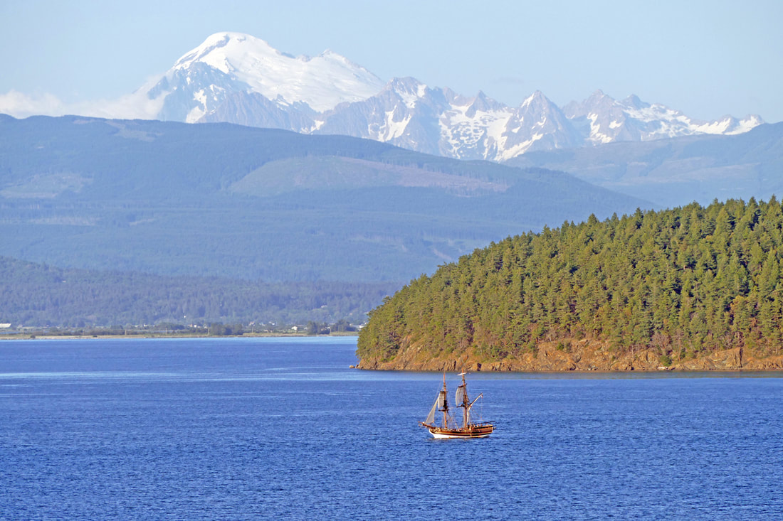 Anacortes was bustling on this busy day, humming with a Waterfront Festival, car shows, art tours, and tourists basking in a weekend of warmth. Now evening shadows grew as the day waned. What better way to finish this day than a visit to Cap Sante, I told myself. It’s not a long trail, and it’s right in town. Having been set aside by townspeople when Anacortes was in its infancy, Cap Sante and its trails are a world apart from today’s city life. Or maybe not. I like to earn the view at the top, so I parked near the marina at Rotary Park, headed up through the disk golf course, past my old house, up 6th Street and then down 5th Street, saying hello to a former neighbor, then into the park at its northeast corner. Just off the trail lies the remnants of the amphitheater where nearly a century ago Anacortesans watched tribal canoe races and boat parades. This evening had a more unusual treat, the “Lady Washington” under sail offshore. I could see it out near Hat Island, tacking on a track back to the marina for the night. Sailing ships fascinate me, the way they fly with the power of the wind, reminding us of an era long ago of rope and leather and wood and canvas. The trail climbs up through ancient trees on the east side of the cape. I picked up a plastic cup someone had left alongside the trail, earning karma points. At the top I discarded it in the garbage bin and emerged into a crowded parking lot. Lady Washington was getting closer, and people were gathering to see it. I ran across the glacially smoothed rocks to get a better view. Passengers on the ship waved as they passed below the cape, but with no sails aloft, using its diesel engine. Oh well. Sharing the hilltop with me were a young couple cheering on the ship, another man taking pictures of his mountain bike, two women in formal dresses heading to a wedding in town, and assorted others marveling at the view as they sat in their cars. Oh, and a raccoon pulling garbage out of the can, then towing it into the nearby brush to feed a growing family. Seagulls and vultures circled above in the strong breezes rising up the western slope. Sunlight blazed on Guemes Channel, the sun approaching the top of Cypress Island. Eventually I headed down the new trail on the west side, a gentle graveled path leading back to Rotary Park at the bottom near the marina. Smoke. I smelled smoke -- that distinct smell of burning wood and brush. There was a large fire here three years ago that blazed through the grasses of this bald and scorched several trees. It couldn’t be happening again. I followed my nose until I found the source: the mountain bike man had a small fire burning in the dry grassy meadow. Rather than confront him, I alerted authorities, and after a lengthy conversation with them to explain where I was, I saw the man riding his bike out of the meadow and down the trail. I ran to where the fire had been and found… wet scattered ashes. I followed down the same trail and heard brush crunching not far away in the woods. I stopped. Another crunch. I turned to see a body moving through the woods, and then recognized it -- a mama deer. It broke a branch and ate the leaves. I relaxed. I ended up at the gazebo at the south end of the Rotary Park trail, just before sunset. Sailboats rocked in the evening breeze, their halyards clanging. I skipped and danced along the paved path back to where I had started; the moon rose, and the sun finally said good night on this most precious day. Directions: From Highway 20 entering Anacortes, take the R Avenue exit, and follow this road to 4th Street. Turn right, then turn right again on T Avenue to get to Rotary Park, or continue on 4th up to an actual 't' intersection. Turn right and stay on this road to the top of Cap Sante.
By Bus: Accessible by Skagit Transit 410 bus at 10th and Q; a short walk around the marina to Rotary Park. By Bike: See above driving directions. Or park at the park and ride on March's Point and take the Tommy Thompson all the way to Cap Sante, avoiding traffic! Accessibility: the Rotary Park trail is wide, flat, and paved the entire way. The trail to the top is steep and graveled. The view at the top is accessible by vehicle. |
Authors
Maribeth Crandell has been a hiking guide in the Pacific NW for over 20 years. She's lived on Whidbey and Fidalgo Island for decades. As a frequent bus rider she easily makes connections between trails and transit. Archives by date
July 2024
Categories
All
|
 RSS Feed
