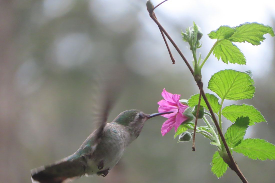
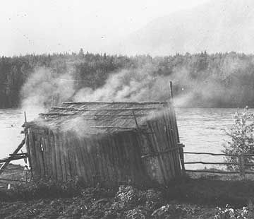
 It was a nice weekend, overcast but warm. I felt like I was coming out of hibernation at last and I was up for a climb. I met Lee and her dog, Piper, and we drove down to the southern tip of Whidbey Island to the Dorothy Cleveland Trail. Her friend, Jan Smith, spoke of Dorothy shortly after her death in January 2000, “She had a spirit of adventure. She had a ton of energy.” You would need it for this trail that goes up and up and up for ¾ of a mile. I remember Dorothy Cleveland as a community organizer whose name was always in the paper hosting events for the League of Women Voters, or chairing a meeting of the Soroptimist, or the Langley City Council, or one of the many other organizations she put her energy into. She drove a little red MG Midget with a license plate that read “GoByBus” and helped start Island Transit. She was an elected member of the South Whidbey Port Commission. So this trail, owned by the Port of South Whidbey at Possession Beach Waterfront Park, is a fitting tribute to her legacy. Lee put a leash on Piper and we took the sidewalk below the caretaker’s house, across the road and over the bridge to the kiosk. A poster showed how the trail twists and turns and suggests a few birds you might see, but the 390 foot climb looks pretty flat on paper. Soon I was envious of Piper’s tendency to pull Lee on the leash. I stopped frequently to take pictures and catch my breath. It has been a long winter. Though no rain had fallen for a few days, the trail had some muddy spots. We danced across them and kept climbing. This park and neighboring Possession Point State Park, have steep trails through maple forests. One hefty snag with bark falling off, exposed the twisted, polished, grain of birds-eye maple. It glowed golden against the grey and brown surroundings. As we climbed, we noticed salmonberry blossoms erupting in their brilliant pink. Hummingbirds noticed, too. We kept climbing. The road snaked around below us with an occasional passing car. We could hear a distant train on the far shore of Possession Sound. But mostly we heard tiny kinglets and chickadees, and the distinctive call of ravens and eagles. One sailed silently above the canopy heading for the water. Steps and benches along the trail assisted us to the top where we rested. Even Piper breathed heavily but she still got excited when someone said, "Squirrel!" An old water tower stood in the forest nearby and a charming little fountain teased us, but no. A few houses sat just beyond the summit on the west side of the ridge. We turned back to the east and began our descent on a little loop back to the main trail. We got a few peak-a-boo views of the water and mountains, but that will be closed soon when the trees leaf out. After coming down the trail we walked the waterfront enjoying this fine spring day where sturdy tables and barbeques await summer picnics. A cattail marsh sang with red-winged blackbirds. An eagle sat majestically in a tree looking over the water. I think Dorothy would be pleased that this trail is named for her at this park that brings people out to appreciate our amazing community. I could just imagine her little red sports car zooming up this curvy road to another city council meeting. You go girl! Maribeth Directions: From Highway 525 at Ken’s Korner shopping center (3 miles north of Clinton), take Cultus Bay Road south almost five miles. Cultus Bay Road will turn right but keep going straight on Possession Point Road and continue another 1.5 miles until you see the sign for Possession Beach Waterfront Park. The trail starts near the boat launch with a little bridge and kiosk leading into the woods.
Bus and Bike: There is no bus service to this end of the Island and I would not recommend it for cyclist on these roads with their steep hills, sharp curves and no shoulders. Mobility: The waterfront park has paved sidewalks and steep lawns. The beach area has a wide path of packed gravel to access the picnic tables. There’s a boat launch where they put a dock out in summer. Vehicles can drive close to picnic tables and beach access. The trail itself is narrow, steep, muddy in places and challenging.
0 Comments
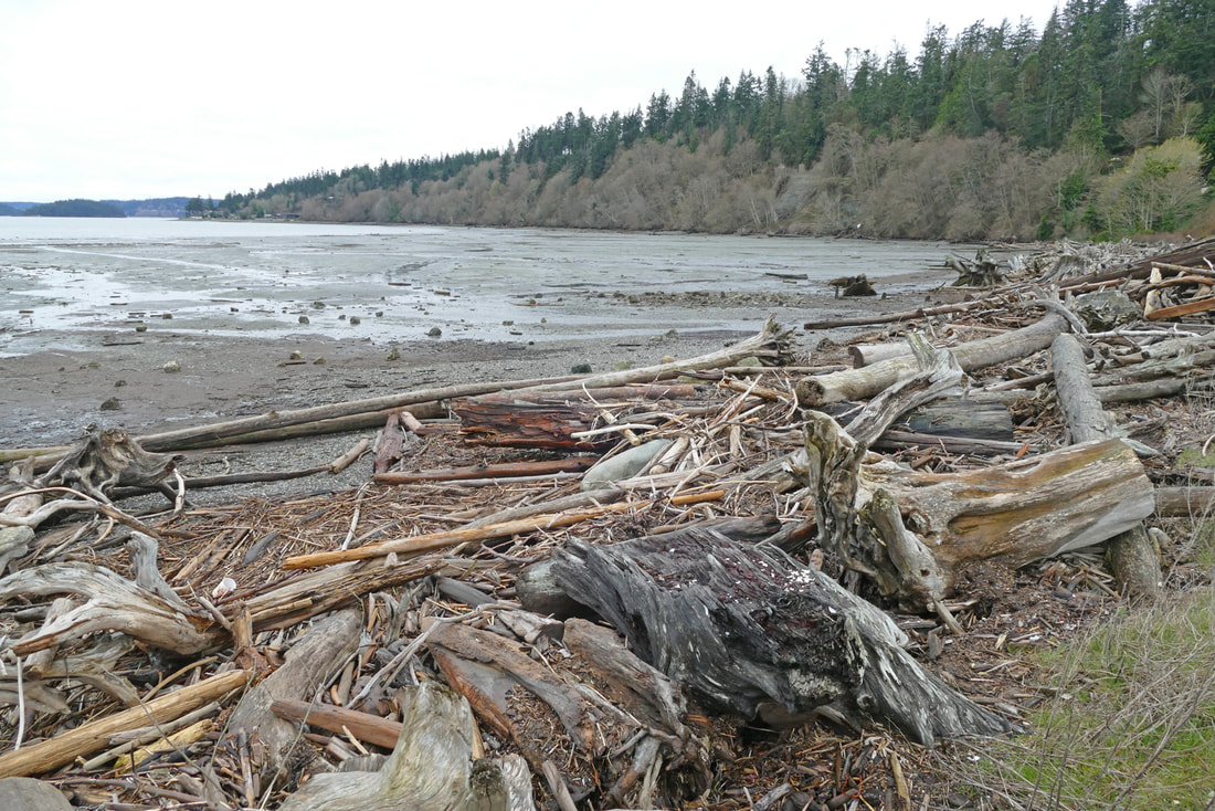
Kath and I approached Similk Beach under misty skies, with rain threatening. The tide was out, far out, revealing a hidden world: shellfish beds, with clams squirting, crabs scuttling, and gulls hovering above looking for dinner. There was more hidden here than I realized, though. The Skagit River brings trees down to the sea, where the wind and tides pile them up on this beach. We wandered among the driftwood, seeing logs and feathers as natural art, finding piles of shells and detritus, while listening to oystercatchers and seagulls at the waterline and eagles at the tree line. Distant Navy jets rumbled and growled. A lawnmower off in the distance hummed a familiar tune. We followed the beach under a forest canopy, some of which was slipping down the steep hillside where they live a transient life between soil and seashore. We scrambled under trees blooming on this first day of spring. We climbed over fallen trees that were now bleached beach logs; I rode one driftwood branch like a wild horse. The mist enveloped us further. Modern houses on the hillside faded as into a dream; the muted sounds of modern life quieted into unknown voices nearby, and we could hear the rhythmic paddling of a large canoe somewhere out on the waters. As the mists swirled, we smelled woodsmoke drifting along the seashore, blending with the scent of low tide. Several women tended a pile of clams baking in a pit on the beach, and children played among small cabins built with cedar slabs not far above the driftwood. Several other folks were down near the water, using digging sticks to find more clams, gathering them into backpack baskets made of native materials. Everyone wore cedar bark clothing and woven cedar hats. Kath and I walked into the village, smiling at quizzical children, smelling drying fish hanging indoors, marveling at the richness of life, the simplicity and complexity of this community in tune with the land around them. The only sounds were the muffled voices, giggling children, the gentle lapping of waves, and the squawking of wildlife sharing in the bounty exposed at the edge of the sea. The canoe faded out of sight as the paddlers rode south toward Kiket Island. We sat together in this separate peace, seeing an alternate world usually hidden, the one all around us in memories and dreams. This beach has been home to a different way of life for hundreds, even thousands of years. In this foggy shroud of the misty day we glimpsed a life, a story, a history unseen in the bright light of summer sunshine, but still here in the quiet backwaters of our treasured islands. People have made their living along these beaches, both in the past and the present. They’ve inhabited our stories, and we’ve felt them riding the wind when we’re alone on a beach or in these deep, wild, simple places. Chief Seattle predicted that “…soon the white man will fill all the land, while my people are ebbing away like a fast-receding tide. And when the last red man shall have perished from the earth and his memory among white men shall have become a myth, these shores shall still swarm with the invisible dead of my tribe. Our dead never forget the beautiful world that gave them being.” The mist around us faded, and the clouds lifted a little. We saw no one now. Once again, the beach was just a simple beach, modern houses lining the hillsides around us, and a lawn mower humming roughly nearby. We gazed at the land around us, the seashore before us, the sky above, life everywhere yet mostly hidden. But as we walked off the beach, as the tide began to rise, I swear I smelled clams baking and salmon drying, and I heard the rhythm of paddles somewhere off toward Kiket Island. jack Directions: From the Sharp's Corner roundabout on Highway 20 and the Highway 20 spur to Anacortes, go east on 20 a half mile to Christianson Road. Turn right and go one mile to Satterlee Road. Similk Beach is in front of you. Parking is available a quarter mile west.
By Bus: the nearest bus service is to the Park and Ride at March's Point Road and South March Point Road, just over a mile from Similk. By Bike: from Anacortes, take the Tommy Thompson Trail to March's Point Road. Follow that south across Highway 20 where it becomes Christianson Road. Follow the directions above to get to Similk Beach. Christianson Road is narrow but with low-volume traffic; it is gently rolling. Accessibility: the parking area is grass and gravel. The beach access is free of driftwood, but the beach is a mix of mud, gravel, rock, and driftwood. Rules: Similk Beach is private property owned by the Swinomish Tribal Indian Community, and is an actively harvested shellfish beach. Please follow the rules posted at the beach entrance. These include no dogs on the beach, and no hiking on the tidelands more than 100 feet from the driftwood. Historical photos: courtesy of various historical websites, taken around the Salish Sea throughout our history. Other photos: by Jack Hartt and Kath Gold.  St. Patrick’s Day brings a jolly occasion of fun and merriment as we wear an outfit or sprig of green to honor Irish traditions and culture. But in a world beset with the invasion of a sovereign nation, and by ever-increasing climate change, the wearing of the green takes on a deeper meaning. I was thinking ahead to March 17 as Kath and I parked at Rotary Park in Anacortes. Our goal was to hike to the top of Cap Sante via the east-side trail, one that is seldom visited yet full of life, history, and meditative views. The day bloomed with sunshine and a hint of warmth. We hiked through the disk golf course and then through serene neighborhoods to a trailhead that enters the northeast side of Cap Sante Park. A woodpecker drummed a rhythm on a dead snag. Indian Plum leaves glowed in emerald green, backlit by the sun. Soon we came to what used to be called “Marine Stadium”, an amphitheater of seating built into the hillside in the early 1920s to allow hundreds of people to watch tribal canoe races, motorboat parades, and other special marine events. 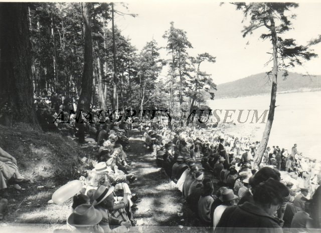 Some of the rows of seats remain, along with the view eastward. We sat on the concrete benches, thinking back on how our world has changed since then, while the land and waters remain. A fully laden oil tanker waited at anchor for its turn to unload its petroleum. As we sat on a nearby rocky outcrop, an eagle floated above us. The birdsong of a Bewick’s wren graced us with joy. Continuing up the east side of Cap Sante, we climbed a rock stairway, nearly a hundred years old, padded now in glistening green mosses. Above the stairway, a tree caught our attention. I know, here we are in a deep forest; why this tree? It stood out because it was huge, for one thing, and lying on the sloping ground for twenty feet, then bending to rise straight upward toward the sunlight above. Then we passed another ancient tree climbing a rocky slope, twisting northward, then aiming skyward with its massive trunk. Life finds a way. Amid the challenges these trees have faced, they adapted and did what they could. Soon we came out onto the roadway, close to the parking lot at the top, nearly full of cars on this glorious Sunday morning. Anacortes and the refinery lay below, as marine traffic came and went out of the harbor. Steam trails rose from the refinery, bending northward in the breeze. Photographers stood on the southern rocks capturing the views with their phones. Some people ate lunches in their cars or sat on the grass, listening to music. Smiles greeted us everywhere as we wandered along the bluff. The ballad “The Wearing of the Green” commemorates an Irish uprising, shortly after our American Revolution, against restrictive British rule in Ireland. I began to see the phrase in a new way. Spring is nearly here. Our planet and our world are suffering, though life continues to find a way. We are called to join a revolution that honors all life. “Even a wounded world is feeding us. Even a wounded world holds us, giving us moments of wonder and joy. I choose joy over despair. Not because I have my head in the sand, but because joy is what the earth gives me daily and I must return the gift. “Knowing that you love the earth changes you, activates you to defend and protect and celebrate. But when you feel that the earth loves you in return, that feeling transforms the relationship from a one-way street into a sacred bond.” -- Robin Wall Kimmerer Kath and I headed down the west-side trail and back home, reminded of that sacred bond, blessed by the joy and hope of spring, and rededicated to the wearing of the green today and every day. jack Directions: Take Commercial Avenue in Anacortes north to 4th Street. To get to Rotary Park, turn right (east) on 4th and then right again on T Avenue. At T and 6th angle left and go to the end of the road to park at Rotary Park. Cap Sante Park lies east and south of here.
To get to the parking area at the top of Cap Sante, go east on 4th street but don’t turn right until you get to V Avenue. Turn right and follow this to its southern end at the top of Cap Sante, where there is parking for about 10 cars. To find the southern trailhead for the east-side trail, look for the 25 mph sign just north of the parking lot. The trail starts near that. To get to the northern trailhead to the east-side trail, turn left off V Avenue at 5th street. Go one block, then turn right on the dead end street. The trail starts on the far left side of the dead end. Note, however, there is no parking here! Find a way to get here on foot. By Bus: Skagit Transit serves downtown Anacortes. From here you must use alternative transportation to get to Rotary Park or Cap Sante Park (see directions above). By Bike: Downtown Anacortes has good bike lanes, and is relatively flat. The route to Rotary Park is flat and scenic. The climb to the top of Cap Sante takes some pedal power, however! Accessibility: Rotary Park has a paved trail that follows the shoreline to a pavilion a quarter mile away. The east-side trail, however, have numerous obstacles, rough stairways, roots, rocks, and other challenges. 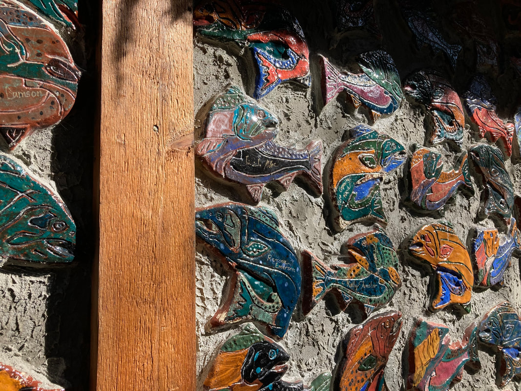 In honor of Billy Frank Junior’s birthday, I visited the Outdoor Classroom this week. It’s a short loop trail with a boardwalk and a deck overlooking Maxwelton Creek. Yet this small site has had a lasting impact on our local community. Maxwelton is the largest watershed on Whidbey Island. The headwaters are near Highway 525. Its course weaves south through the valley among homes, farms, beaver ponds, and reed canary grass all the way to Maxwelton Beach. In the 1850’s the creek was thick with salmon, but dikes, tide gates, and development have significantly altered the landscape. The Outdoor Classroom was established thirty years ago to help protect and restore the creek and educate students and watershed residents. The project started with two teachers whose students raised salmon in their classrooms. After a few months, the growing fish needed to be released into a stream. Creek side property owners allowed the students to come and free their fry. When a few acres came up for sale on Maxwelton Creek the teachers formed a non-profit organization, Maxwelton Salmon Adventures. The community donated money, energy, and materials to buy the property, build a classroom and make trails and learning stations. People who made donations got their names on a colorful ceramic fish plastered to the side of the building. When the effort was expanded to other watersheds, the name was changed. Whidbey Watershed Stewards has worked on restoring Robinson Beach, Old Clinton Creek, and the Freeland Wetland Preserve where there’s another trail that’s open to the public. Over thirty years many students have visited the Outdoor Classroom. An education director trains volunteer instructors. Classes of K-5 students rotate through three stations, one on the creek, one in the classroom and one on the trails. Each season students focus on different aspects of the natural environment. They study the stream, birds, native plants, mushrooms, and of course, salmon. The fish raised in the classroom are still released at the site each year. On my recent walk, the trails were littered with branches from winter storms. The stream was dark brown with foam piled in the corners due to it passing through a peat bog in the valley. At the classroom I could see teaching materials stacked inside. And there were signs of spring. Indian plum bloomed in the sun. Skunk cabbage emerged in the wetlands. Chickadees foraged in the treetops. I sat on a bench and listened to the murmuring creek. A work party is planned to clean up the site. Next month volunteers will undergo training and classes will begin. Years ago this was one of my usual and accustomed places. I was one of those educators, leading small groups in learning activities. Most classes come once or twice a year through elementary school. By the time they reach fifth grade they have a good understanding of the importance of wildlife habitat. It gives me hope. For those who don’t know, Billy Frank Jr. was a member of the Nisqually Tribe who fought for Native American fishing rights in the 60’s and 70’s. Due to declining populations of salmon there was an all-out war over fish. Billy Frank was first arrested for illegal salmon fishing when he was just fourteen. He went on to become an activist and spokesperson for his people. The case over treaty fishing rights went to the U.S. Supreme Court. In 1974 Judge George Boldt affirmed that Washington State tribes had the right to fish in their “usual and accustomed places” as was stated in the treaties. The Boldt Decision made the twenty treaty Indian tribes in western Washington co-managers of the salmon fisheries along with the State of Washington. Billy Frank Jr. served as chairman of the Fisheries Commission for over thirty years bridging the cultural divide and working on environmental sustainability on behalf of all of us. President Barack Obama awarded him the Presidential Medal of Freedom posthumously in 2015. To learn more about the Whidbey Watershed Stewards and the Outdoor Classroom, or to volunteer visit here. Maribeth Directions: From Highway 525, 4 miles north of Clinton on South Whidbey, turn south on Maxwelton Road and drive 3.4 miles. You'll pass Erickson Road just before the Outdoor Classroom sign on the left. French Road is just beyond. Take a moment to look at the beautifully carved sign by Pat McVay.
Bus and Bike: There is no bus service to the Outdoor Classroom at this time, but it's an easy 3.4-mile bike ride on a wide shoulder along Maxwelton Road. Two or three bikes will fit on a bus bike rack. The fare free Route 1 bus will stop at Maxwelton Road and Highway 525 Monday-Saturday. For a schedule click here. Mobility: The trails are flat but narrow with roots and branches that may pose a problem in places. The boardwalk is wide enough for a wheelchair and the covered deck has benches overlooking the creek. There are no restrooms. |
Authors
Maribeth Crandell has been a hiking guide in the Pacific NW for over 20 years. She's lived on Whidbey and Fidalgo Island for decades. As a frequent bus rider she easily makes connections between trails and transit. Archives by date
July 2024
Categories
All
|
 RSS Feed
