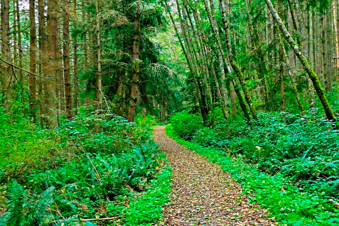
 ... And no one hears it, do we still mourn? If a man says I can’t breathe and no one does anything about it, does anything change? If a forest burns and we can’t breathe and nothing changes, will we breathe any better next year? It takes me about a mile or more of hiking, usually, before I start to sluff off the mental chatter rattling around in my head and experience the beauty around me. My thoughts start to expand beyond my own small universe and I begin to pay attention to the music of the spheres, the life that surrounds us wherever we are. So it was as I toured Dugualla State Park. The smoke from millions of acres of burning forests had just blown elsewhere. It was an overcast, dead-calm afternoon as I walked past the old gate. Usually I hike the trails clockwise. This time I reversed the direction, making right turns every chance I had, which took me down the Wetland Trail to the south. After about a mile, my pace slowed a bit, my pulse also slowing as I finally let my eyes and ears and nose speak to me. Being in the woods was working its magic, healing my mind, body, and spirit. I listened to nuthatches, I saw hemlocks and huckleberries, I smelled the rich earthy breath of the forest giving way to fall. CRACK/CRASHHHHHH/rumblerumblesettle… silence. I looked toward the direction of the sound, obscured by a hundred yards of salmonberry and rose thickets. It was the unmistakable sound of a tree falling in the forest, no breath of wind to give a push, no chainsaw noise to topple the giant. The tree’s time had just come, and it fell. I walked on. We take for granted that there will be breathable air, clean water, stately trees, comfortable trails, and years of life ahead for all of us to enjoy. Until we realize that any of these precious gifts can be lost to us in a heartbeat. I used to walk this trail at least once a month for years. It had been a couple years since I had last been here. I came around a corner where the forest has always been deep and comforting, and instead a bright clearing filled with a brand new house stood adjacent to the trail, just a stone’s throw away, with private property signs posted on several trees. Sigh. If an old-growth forest trail becomes a walk through a suburban neighborhood, has anything changed? I met a couple on the trail confused about how to find the beach trail. There used to be a sign, I said, but if it’s not there, just go back along this trail and turn right at the big tree. You can’t miss it. The man smiled knowingly and they took off. I followed at a respectful distance, although I caught them at the big tree and they kindly took my picture. Then we all hiked down to the beach, where I wandered across the wide strand of low-tide mud, slippery gravel and seaweed, and forest logs strewn up and down the shoreline beneath a densely-canopied forest. Eventually I headed back up the steep bluff and turned right again at the big tree, leading me up the very steep North Trail. No wonder I like going clockwise, I noted mentally. This is work going up this stretch of trail, especially after climbing up from the beach. The trail leveled out again, of course, and memories of building the trail came flooding back. Along the way I met others finding their own way to explore Dugualla, alone or as couples or families, each experiencing the hike, the forest, the trees, the seashore, the journey of discovery in their own way as we all took time to listen, and hear, and wonder, and marvel at the life and stories along the trail. jack Directions: Take Highway 20 four miles north of Oak Harbor to Sleeper Road. Follow Sleeper Road east three miles to its eastern end where you will find the small parking lot and the gateway to the park.
0 Comments
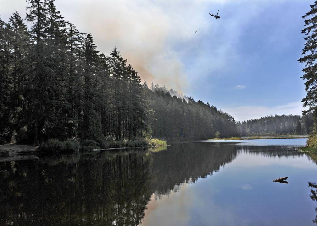 There’s fire. My first summer in Washington was spent working for the US Forest Service. I was on a “brush disposal” crew. Our job was to clear the slash off of clear-cuts by setting it on fire, and then to control the fire as best we could. It was the hardest work I’ve ever done. One late afternoon, after we’d dug a fire line around a fifty acre clear-cut, the torch crew walked back and forth lighting the top end of the site and working their way down. We moved silently along our fire line. It was a steep site and as evening came upon us, the fire grew in intensity. The heat radiated off the slope until the crowns of the tall evergreen trees at the low end of the site burst into flames. The fire burned through our canvas hoses so we chased the sparks and burning branches with shovels and pulaskis as they fell. We worked all night putting out embers as they dropped to the forest floor. At dawn we were relieved by a fresh crew and taken back to camp. I thought I’d stay up all day and go to bed at the usual time. But just as I crawled into my bunk, they called us back out on the fire. We have smoke here which keeps me indoors. I’d like to be hiking, or gardening, enjoying the last few weeks of summer. But I can’t complain. I feel for the people who are suffering, the loss of life and property, and the plant and animal life, both wild and domestic. And I feel for the firefighters who are working around the clock to try to contain these wildfires. A few days ago I caught myself thinking, “I’m glad I live on an island,” as if the water would save us. A moment later I realized it could happen here, too. And it has! In the 1980’s when I worked at Fort Casey State Park, I was called to Ebey’s Bluff where a beach fire on July 4th had smoldered for days before a breeze blew it back to life. The embers went sailing into the dry grass on the bluff. Fortunately, a fire crew responded and put it out leaving a smoking black scar. In 2016, a fire burned at Little Cranberry Lake in the Anacortes Forest Lands. In 2010 a cigarette started a fire at Fort Ebey State Park. Jack Hartt told me he'd responded to another fire on Hope Island in Deception Pass State Park. There was a fire at Bowman Bay in the 1990’s. A few years ago a fire caught at Sares Head at Sharpe Park just a half mile away. So yes, we have fires here, too. I grew up with Smokey the Bear, who was developed by the USFS to teach us about fire prevention. Smokey’s original message back in 1944 was “9 out of 10 forest fires are manmade”. Smokey taught us how to “douse our campfire, stir it and douse it again.” Later, a new message, based on the war-time posters of “Uncle Sam”, showed Smokey pointing a finger and saying, “Only You Can Prevent Forest Fires.” The latest slogan says, “Only You Can Prevent Wildland Fires” which includes grasslands. All of these messages are still critical. Land use agencies have learned a lot about forest management and fire prevention over the years. With controlled burns, they can reduce the fuel loads and minimize fire impact. Before the first white settlers arrived on Central Whidbey, the Salish used fire to keep the prairie clear of trees and open to camas flowers, an important food source. The Whidbey Camano Land Trust successfully used small controlled burns for prairie restoration at Admiralty Inlet Preserve. The Whidbey Island Conservation District offers a program called Firewise. They help you determine how to prevent devastating loss should a fire occur in your neighborhood. They will work with individual property owners or with the whole neighborhood. Find out more at www.whidbeycd.org/firewise.html Maribeth Directions; Stay inside until air quality improves. Be careful with fire. Never leave a fire unattended. Have a shovel and water ready. Keep flammables away from your home and outbuildings. Check out the Firewise program.
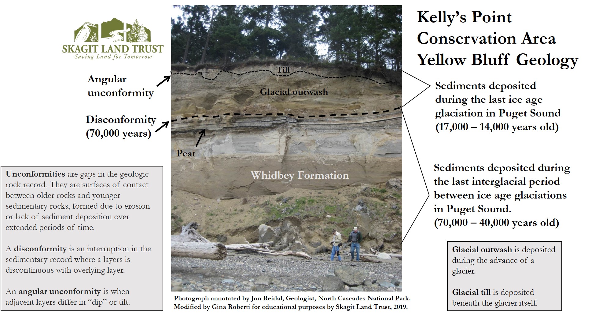
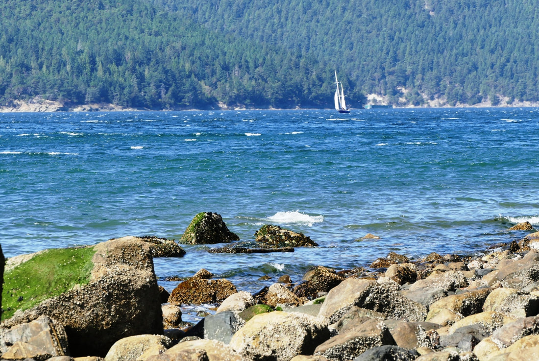 Sometimes our hikes aim for a destination. Sometimes we look forward to the conversation with others as we journey along a trail. And sometimes we see that the journey itself is the destination, whether shared or just experienced alone. On a very warm, very breezy Labor Day I rode my bike to the Guemes Ferry dock, crossed on the ferry, then biked a mile west to the trailhead of Kelly’s Point. The new gravel parking lot holds a handful of cars. I locked my bike in the bike rack and became a hiker. A short trail heads to the beach, with a beautiful curving bench giving a view out over the west end of the Guemes Channel; a short stairway drops down to the beach itself. Turn right here to follow the beach and bluff line northward for a half mile. The first half of the beach is quite rocky, especially below the high tide line. The second half stays cobbly at the lower end but the constant erosion off the bluffs fills in the upper beach with abundant sand. Kelly’s Point is best hiked at a low to mid tide. At high tide, the water is up against the base of this 100-foot high, ever-changing erosional bluff and an alder forest doing its best to hang on. The bluff starts out low at first, then gets higher as you head north, then eventually starts to lower again as you approach the private property at the north end of the Skagit Land Trust property. The Trust land is sandwiched between private property at both ends of the property. Being vertical sand faces, the bluffs allow unfortunate graffiti to be carved into them at the beginning, but beyond that I found almost nothing – except for two words: “I LOVE.... The object of this love and devotion has been erased by erosion some time ago. Hopefully the love has not also been erased, but erosion of all kinds happens in life too. I said a short prayer for “I” and his or her love. Then I considered that maybe there was nothing missing at all; maybe it was just a two-word sentence, which changed the scope of these sentiments and made me hope that we all share these two words as our daily prayer. I walked north on the beach, reveling in the comfortable warmth of the day even with a 20-knot wind coming down the passage between Guemes and Cypress Islands. This was an unusual day in the northwest, without question, as a tank top and shorts were all I needed even as the powerful breeze filled the channel with whitecaps and kept most of the seagulls sitting this one out. Halfway up the beach one alder covers the upper beach with its many branches, and then a series of trees block most of the beach with the remaining bones of their trunks and branches. They slid down the bluff not many years ago; they remain as natural habitat and a reminder to us all that this beach is in constant motion, the bluff constantly shedding material to feed the beaches up north. When I reached the private property at the north end, I enjoyed a small snack and then headed back down. Alone in my thoughts, I valued this sunny stretch of beach to enjoy the views, the reveries, and the renewed focus it gave me. Even though it was a sunny Labor Day, I didn’t meet anyone at all on the beach until I got back to the trailhead, where I saw two women beginning their walk north. New discoveries were just beginning for their journey together. I rode back past towards the Ferry, passing Peach Preserve as I rode, which made me think of food, which led me to the Guemes Island Country Store where I enjoyed some chocolate Coconut Bliss ice cream before heading home! Geological history: http://www.skagitlandtrust.org/files/documents/kellys%20point_yellow%20bluff_annotated%20geology_jon%20reidal.jpg jack Directions: From Anacortes, take 6th Avenue west from Commercial Avenue to I Avenue, and board the Guemes Island ferry. After arriving on Guemes Island, go west on South Shore Drive about a mile to where it turns north as West Shore Drive. The parking area and trailhead are at this corner.
Recent history: In 2017 the Skagit Land Trust began seeking money to buy Kelly’s Point and Yellow Bluff. Within a year, they were able to purchase the property thanks to donations from area families, businesses and organizations, and a Fish and Wildlife grant. 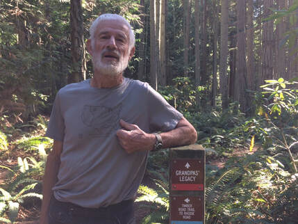 We’re turning the corner now, leaving summer and entering fall. It’s getting dark earlier and I’m feeling the pinch on my hiking time. This may be the last month I’ll be able to take a hike after work, so I wanted to take advantage of our lovely late afternoons for a walk with a friend. Vin Sherman and I used to work together at the County. That’s where we discovered our common love for hiking. Vin was hiking the Pacific Crest Trail then, spending his vacations hiking the long trail over 17 years. I had thru-hiked the Appalachian Trail a few years before we met. Now Vin is helping his friend Teresa, a little white haired choir director, who has already hiked the Appalachian Trail and the Pacific Crest Trail, and is trying to finish the Continental Divide Trail and complete the Triple Crown. But this week, while Vin is home, we just went to a local trail in Coupeville at Rhododendron Park. Vin’s favorite hiking partner is his 4 year old grandson, Zander, who had just spent a week with him. They had hiked 13 trails out of Hiking Close the Home. Vin told me about their hike at Rhody Park on the perimeter trails. One trail, the Grandpa Trail, was named after him, or so he thought. I saw a mighty big tree on that trail and had a hunch it might have been the namesake, but I said nothing to Vin. Rhododendron Park is flat with pretty uniform 2nd growth trees. But the walk was fun, due to the company and conversation. The first half of our conversation was broken into bits, interrupted every few seconds by a jet taking off at the OLF runway next door. We would plug our ears, look up at the tree tops and wait. After a moment we could share a few more words. But then stop, look up and plug our ears. Vin told me the pilots hate to practice at night but it is required, so they practice when there's a full moon. That explains why I've been hearing them, like distant thunder, as I go to bed these last few nights after watching the moon rise. We emerged from the woods on the far side of the park on Patmore Road. After walking a short ways east, we turned back into the park where there are ballfields, a restroom and a picnic shelter. That’s where we could see the jets and how close they were to the tree tops. A couple pitched a ball and batted to each other, but otherwise the fields were empty. We re-entered the woods where a sign showed all the trails and we decided to continue on the periphery. Finally, our conversation flowed uninterrupted. The jets were gone and the second half of our walk was a pleasant sharing between friends. I could hear chickadees, woodpeckers and ravens. Vin pointed out trip hazards, roots and horse manure, both of which were frequent on some trails. I stopped to take photos of things that caught my eye. When we arrived back at the entrance we decided to go through the middle on the old Rhodie Road. Vin said when he was growing up here, they used to drive through the park on this paved road the night of the prom. The park is thick with native rhododendrons which bloom profusely in the spring, like a florists shop full of corsages. The campground is closed with a gate this summer, but you can take a bike or stroller or wheelchair around it to gain access to the wide, paved, flat road that’s shady and cool on a hot day. Before I caught the bus home, Vin gave me a bag full of corn on the cob, fresh picked on Ebey’s Prairie. The best trail dinner I’ve ever had! PS We started this blog a year ago and what a year it has been. Ya'll have a good Labor Day Weekend. Stay safe, stay strong and stay close to home! Maribeth Directions: From the stoplight in Coupeville at Highway 20 and Main Street, walk or bike 1.5 miles south on the Rhododendron bike path, or drive 1.5 miles on Highway 20 to the Park entrance.
By Bus: Take the Route 1 bus northbound or southbound and ask to be let off at Jacobs Road just south of Coupeville. Then walk the bike path a short distance south to the park entrance. |
Authors
Maribeth Crandell has been a hiking guide in the Pacific NW for over 20 years. She's lived on Whidbey and Fidalgo Island for decades. As a frequent bus rider she easily makes connections between trails and transit. Archives by date
July 2024
Categories
All
|
 RSS Feed
