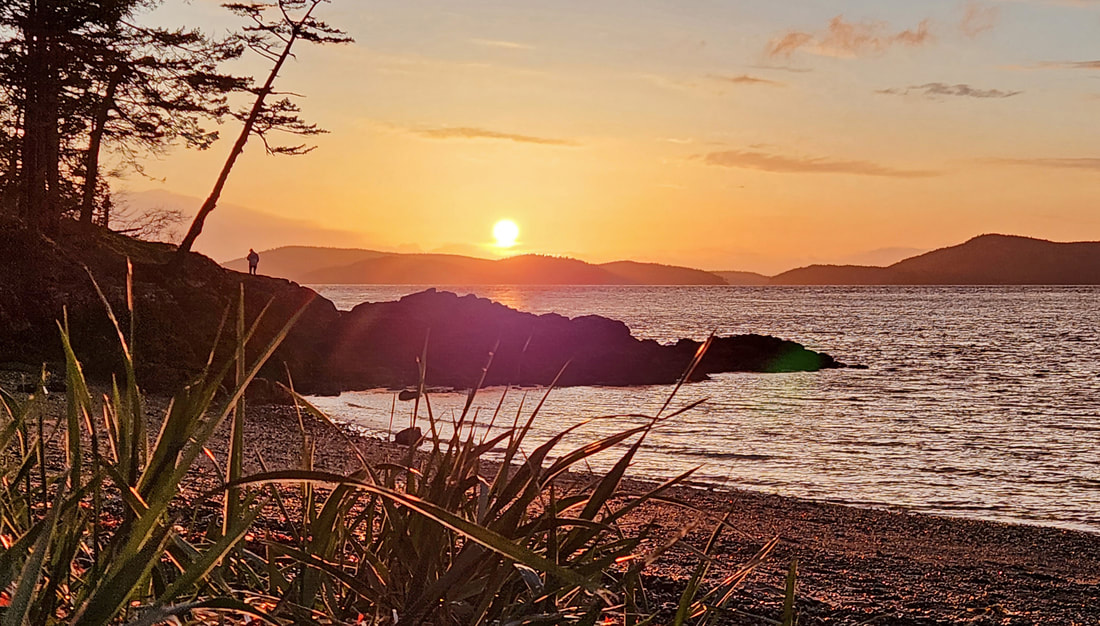
 Trails abound not far from our back doors. This is the kind of privilege we all have, those of us who live on Whidbey, Fidalgo, or Guemes islands. We may have to hop on a bike, catch a ride with transit, or drive a few minutes to get to the trailhead, but we all have trails we call our own because they are close, and we frequent these places as often as we can. Washington Park is the place Kath and I call our own. Our home is a hundred yards from the park boundary. Can’t be much closer to home than that. With over 200 acres of headland bluffs and forests, it fills the west end of Fidalgo Island. We visit some corner of the park several times a week. It’s a privilege and a joy to call it a part of our backyard. It’s the place we find shade on a summer day, snowshoe or ski in a deep snowfall of winter, warm ourselves on a south-facing rock on the first sunny day of spring, explore a shoreline at low tide, catch a sunset from the point, study wildflowers in the meadows, marvel at the mystery of fog-enshrouded shorelines, immerse ourselves in the breathing forest, walk off a dinner of too much pizza, or just take Murphy for a stroll. But not today. It’s pouring down rain. Lightning flashes catch us by surprise; then thunder cracks overhead. We’ve had weeks, months of sunshine it seems. Today the weather has changed. And we are content to just take a short jaunt, then retire back home and look back on previous adventures in our “backyard.” One of our hikes is to “first kiss rock,” a southside point near the water’s edge where Kath and I – as you can guess – had our first kiss. The southeast corner is our most frequent hike as we loop from the cabana up into the forest and back down into Skyline via kind neighbors who provide access through their side yard. Along the way we pass two magnificent trees, growing side by side for hundreds of years, witnesses to longhouses from centuries ago giving way to the megahouses of today. Some of our walks take the north trails from Sunset Park to the spectacular Green Point, where all of life’s cares fade away into the expanse of the San Juans beyond. We have scrambled, sweated, and occasionally scratched our heads finding our way to hidden overlooks, deep forest glens, geologic wonders, and moss-covered places to get lost, find, and renew ourselves. Sometimes grandkids go with us, the length and challenge of the hike dependent on their energy levels. And sometimes we go alone, our feet taking us where our hearts wander, finding beauty and joy or just silence and solace during a stressful stretch of days. As summer begins to slip into fall, join us in looking back at some of our memories on these “backyard” trails, and to looking forward to the stories still to come. jack Directions: from downtown Anacortes, take 12th Avenue west, which becomes Oakes Avenue, which becomes Sunset Avenue which takes you right into the park.
By Bike: The car route is busy, and somewhat narrow, but gently rolling and worth it when you get here. By Transit: Skagit Transit goes to Skyline, a residential area just a quarter mile from the park entrance. Mobility: The Loop Road is paved, though steep in places. It is closed to automobile traffic in the morning until 10 a.m. There are some ADA pathways, at Sunset Beach, Green Point, and the Burrows Channel overlook. The trails are rough, steep, and narrow, mostly.
0 Comments
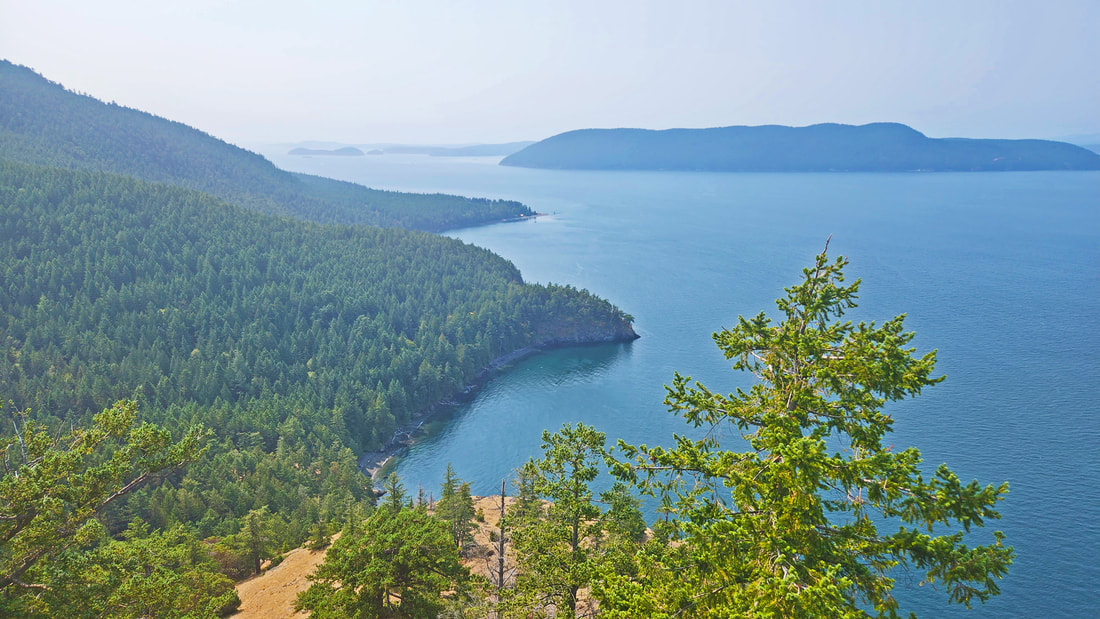 This week our Hike of the Week departs from Whidbey, Fidalgo, or Guemes islands to visit a next-door island, still close to home, still in Skagit County, one that I see almost every day just across the water from Anacortes: Cypress Island. The island is mostly owned and managed by DNR, with parts of it set aside as natural area preserves, or in conservation easements. Trails and adventures abound. Many of you have probably been there, some of you probably several or maybe dozens of times. It’s so close to home, just a short paddle across Guemes Channel then drafting off Guemes Island to land at Cypress. Everyone who describes Cypress to me mentions wonderful places to camp and adventurous trails to explore. Well, I had never hiked there. It was a long-overdue bucket-list item. On our paddle over, we had strong northerlies in our face, so we took refuge at Cypress Head and set up camp in a delightful site with views over Guemes to morning sunrises. Our goal for the next day was Pelican Beach at the north end of Cypress, and to hike from there to Eagle Cliff, a ‘not-to-be-missed’ destination we were told. And then back to Cypress Head. Twelve miles of hiking, that was our goal. And over 2000 feet of elevation gain. Each way. Cypress is a steeply mountainous island. I had no idea how far we would really be able to go. Early in the morning, as a red sun rose over Guemes, we crossed the tombolo and headed west, and immediately up, steeply up. Near the abandoned airport we turned north. Maps are essential here. Trail markers mention destinations, though often not how far it will be. Yet interestingly, in the middle of nowhere, we would come across a wall of well-written interpretive panels giving us natural history stories. No maps included, but good stories. We descended to Reed Lake, savoring the fact it was now downhill almost all the way to Pelican. The trail climbs a little to get to Duck Lake, or more accurately “pondlily” lake, as we could see no water in the lake, just thick vegetation. Then a short jaunt through sparkling maples and ferns led us to Pelican Beach. Composting toilets welcomed us, as did sunshine reflecting off the water, and a beach made up of a million perfectly shaped skipping rocks. It was time for lunch. After hiking four and a half miles to get here, up and down, and up and down, our lunch was delicious! From here it’s just over a mile to climb 752 feet to Eagle Cliff. The trail is beautiful, through open woods that break out into grassy meadows before the final ascent to the rocky top. The peak gives nearly 360-degree views of Rosario Strait and the San Juans. Definitely worthwhile. Then began the long hike back to camp. Up and down, then a big UP for two miles, then back down to Cypress Head. The final 100-yard-long stroll up to our campsite was an extreme effort of endurance and exhaustion. And exhilaration. And well-deserved rest. Cypress has so many hiking options, all of them a climb. You can aim for Cypress Lake at 1000 feet, Bradbury Lake at over 1100 feet, or the four peaks of Cypress, coming in at over 1200, 1300, 1400, and the highest at 1500 feet. Or hike to Strawberry Bay, or Tide Point, or many other interesting destinations. We did not do those on this trip. Maybe next time. We paddled back the next morning, into the wind. Why is it always into the wind? People say that what we’re all seeking is a meaning for life…. What we’re really seeking is an experience of being alive, so that our physical experiences resonate within our innermost being, so we feel the actual rapture of being alive. -Joseph Campbell jack Directions: from Anacortes, paddle north a few miles to the east shore of Cypress. Or drive onto Guemes Island to the park at the north end for a shorter paddle. Or get a ride from a private boat service that will drop you off anywhere you wish. We were tempted to call for a ride back to Cypress Head when we were at Pelican!
By bus, or bike? Nope. Mobility: Tough trails, though well made. Steep, rocky, rooty, or flat and wide, depending which part of the island. Did we mention steep? 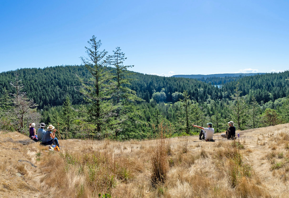 The Skagit Land Trust (SLT) has actively engaged with our community and partners to protect at-risk lands throughout this county for decades. Several parcels in Deception Pass State Park are protected because of their hard work and because of the generosity of donors who support their mission. This week’s Hike of the Week was one way the SLT thanks the many donors who have contributed to the protection of lands such as these. Ten of us gathered at the Pass Lake parking lot at 9:30…ish. The trail was advertised as “… 3.8 miles with some moderate inclines and uneven ground.” My role was to lead the walk and share stories along the way. I always look forward to opportunities like this, especially this trail, one that I helped create from one end to the other. The weather: very warm, a perfect temperature in the shadows of the trees, although a little painful in the blaze of open sun. We hiked clockwise on the loop, first through old-growth, a section built by my son Charlie, then an uphill stretch where we identified common trees (and caught our breath). From here the trail drops down, then climbs again toward the newest addition to the park, a 78-acre parcel that the SLT was instrumental in helping protect from owners who were intent on cutting nearly every tree to build potential homesites. The boundary line is obvious right now, but in half a dozen decades, the forest will again be refreshing. On the way to Naked Man Valley, we linked arms around the Big Cedar, marveling at its size, and at its age of several centuries. Imagine life here in the 1500s! From here we descended steeply to the bottom of the valley. We circled up to do a group listen, closing our eyes and opening our ears to listen for whatever sounds we might hear, counting with our fingers each one. One, two, three, four, five… bird songs, bees, wind in the trees, insects, a different bird… but not one human-sourced sound, other than our own breathing. In a world increasingly crowded, noisy, and paved over, this valley is a respite for sore ears. 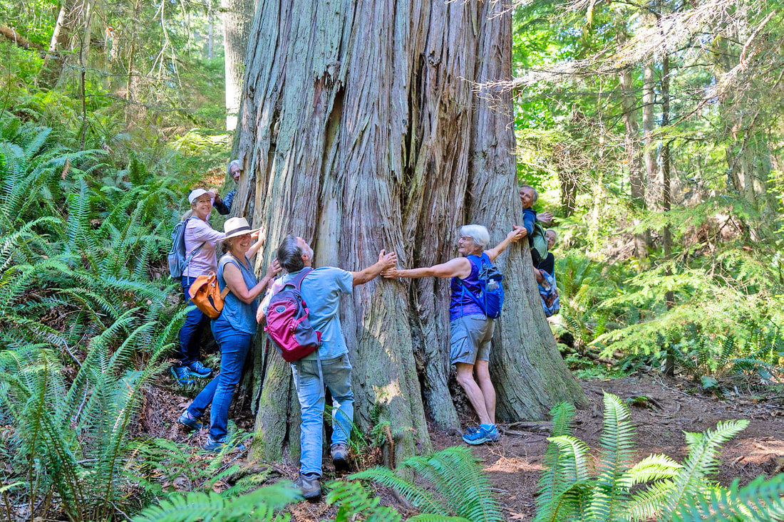 Then it was another steep climb up to the old homestead, going from cool shade to blazing south-facing open slopes. Stories of pioneer days, homesteads, orchards, rock quarries and garbage, artists, farmers and forest fires filled our imaginations. Back at the magnificent overlook we chose our preferred picnic sites, some in shade, some on the edge of the cliff and view, and chowed and chatted. It was past noon, so we headed back. An owl flew close overhead and watched us from a nearby tree. Down we descended into the quiet coolness of Naked Man Valley again to hear the story of that name, only to climb back out of the valley to the ridge leading to Pass Lake. At the ridgeline, highway traffic raised its voice and followed us the rest of the way home. Along the way we talked about the CCC and the legacy of John Tursi, a teenage delinquent in New York sent out west during the Depression to be worked into shape as a member of the Civilian Conservation Corps. His life was changed; eventually he became one of the SLT’s largest donors for land preservation. The north half of the trail is named in his honor. We climbed one final hill as we approached the parking lot. Opening our car doors, one of the hikers re-read the description of the hike to us all for a laugh: “3.8 miles with some moderate inclines and un-even ground”, she said, emphasizing the word ‘moderate.’ It worked. We laughed as we remembered the many ups and downs of the day, the heat and shadows, the sweat of the trail, the sweetness of our surroundings, and the stories that shape the trail today. All photos by Eric Hall of Skagit Scoop https://skagitscoop.org/ Directions: Just north of the Deception Pass Bridge, turn northwest onto Rosario Road, then immediately to the right into the Pass Lake parking area. Parking at the north end of the trail is at the intersection of Donnell Road and Campbell Lake Road.
By Bike: Highway 20 is high speed, busy, and with narrow shoulders in this area. Rosario Road is a lower speed, fewer cars, but even narrower shoulders. Both are hilly. Mobility: The trail is very steep in places, rough and tumble, but mostly wide and well marked. 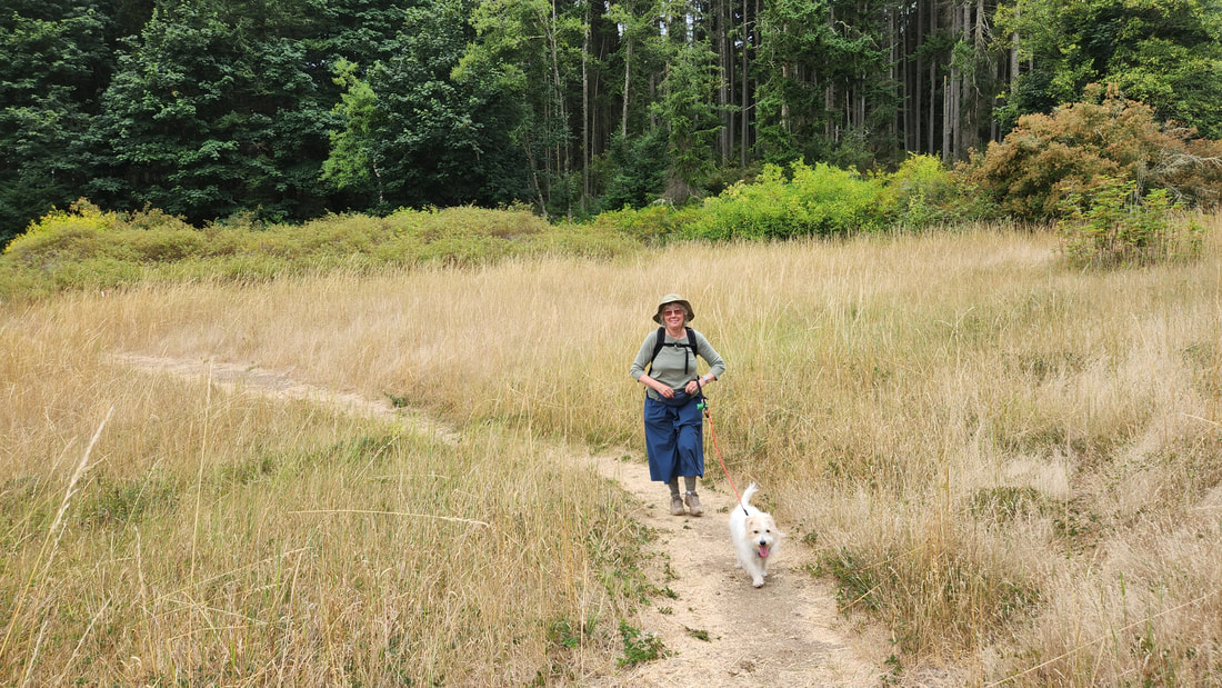 “Will we see Bruiser?” Every time we visit Strawberry Point, that is forefront in our minds, and in many other people too, the anticipation that maybe, just maybe, we will see Whidbey’s only and lonely bachelor elk, nicknamed Bruiser. He lives in the neighborhood. The first time we came here, we saw him at the edge of the meadow not far from the trail where we stood. That magical encounter set up what has become almost an expectation for every visit now. Also in our mind is the hope and expectation of finding a tranquil forest and meadow full of life, because that is also what we have experienced every time we have visited. After a week of warmth and clear skies, this day dawned with clouds that threatened a little precip. We could use it. Along the way to Strawberry Point we stopped at a highly rated pet place and toured the facilities with the office manager. We will be spending our first anniversary next month taking a long hike, a situation not suitable for Murphy, so we needed to find alternate care for him. Dogs of all sizes barked and jumped at us as we walked through the cages and walkways and around the grounds. The cacophony of noises drowned out conversation. Afterwards, Kath said the place looked to be professionally managed and the dogs well cared for. I had flashbacks of jails I have been in – no, not as a convict; just part of my previous work life! – but I couldn’t shake the impression of the dogs being in prison. Kath nodded her head; it’s not home, that’s for sure, she said. The still-fresh echoes of dozens of dogs barking made the absolute dead silence of Strawberry Point Reserve a shocking counterpoint. The quiet was palpable. No walls, no limits, no noise, just wild freedom, a land set aside for wildlife. We started out whispering to each other as we hiked, unwilling to interrupt the reverent quietude. We began to hear small birds around us, wood-pewees and chickadees. The forest at the beginning is mostly regrowth from earlier logging. The trail is still woodsy, rough, fitting in with the landscape, though well-trod now from a year of fellow hikers. The trail leads to a maple forest, then opens into a large meadow, the centerpiece of the reserve. Once again our voices became hushed; our expectations held high that maybe, just maybe, Bruiser might be wandering nearby. The meadow trail has been rerouted to follow the upper edge of the meadow, leaving the heart of it for wildlife. Wise move. We crossed through with alert eyes and ears, hoping, anticipating. We saw no elk, but several songbirds brightened the fields. Entering the forest again at the east end, we headed to the right, wandering through a stand of firs, uniform in age, devoid of much undergrowth or life. Then the trail breaks out into a diverse mosaic forest, vibrant with old maples and young saplings, grasses and elderberry. Bird songs filled the air: Swainson’s, creepers, flycatchers, woodpeckers and more. Again we walked in silence, slowly, looking carefully, hopefully. The trail eventually rises to its high point, where we shared water and a bite to eat while we watched birds and squirrels flit and dance around us. Then down the other side and into the meadow again. One more chance to see the elk. Slowly, quietly, we crossed back through, checking the shadows and shrubs for any sign. At the west end, we took one last look, loving the landscape laid out before us, the grassland, shrubs and trees. All was peaceful, the home of Whidbey wildlife. We did not see the iconic elk. But by hiking slowly, quietly, reverently, we found a natural world alive and intact, one where we can immerse ourselves as passing observers. We can look forward to that every time. jack And check below for an alternative perspective, a 2-minute read... [Some alternative thoughts a few days later, if you wish. Is it anthropomorphic, or do we intrinsically view wildlife as beneath us, without similar values to ours?]
“Success, recognition, and conformity are the bywords of the modern world where everyone seems to crave the anesthetizing security of being identified with the majority.” Martin Luther King, Jr. Not so Bruiser. This is the name residents of Whidbey have given to our only elk on the island. He has been here for many years now, probably most of his life. He is large, and appears to be healthy and satisfied with his home. He has not succeeded in finding a mate, for whatever that is worth. To some, to the longevity of his species, it is everything. Most every elk pursues that course, and good for them to maintain the strength of the herd. But he is not “most every elk.” He has not sought out conformity, and in fact ran and swam away from it, crossing forests, farms, and fields, even Interstate 5 and a couple miles of saltwater, to arrive here. That is not the story of a conforming, safety-seeking elk. And he has gathered no recognition from the other members of his tribe of birth. He hasn’t seen them since he emigrated to Whidbey from Skagit Valley. The men of his tribe have used their antlers to measure their strength against one another, and have established reputations with the elk ladies as to their comparative desirability as a mate and father. No, this elk makes no comparisons, measures his success against no one else but his own values, and conforms to the life he has chosen, rather than one chosen for him. Maybe originally, years ago, he was looking to start a family with any female elk who may have had the temerity as he did, to leave the herd and try Whidbey as a better home. He found none here. On any day he could have given up on this dream and returned to his birthplace, ready to be like others. But he didn’t. He chose to stay here, and continues to choose that path. No, he is not a creature to be pitied, but respected for choosing the life he lives, accepting it as he finds it. Nor is he to be fawned over, as our pet wild elk, the one we can go visit anytime we wish like he’s an exhibit in a zoo, with descriptive signs posted that define his life history with letters and pictures. No, he is a wild elk, one who creates his life as he chooses to lead it, every day, in summer and winter, feast and famine depending on the habitat he finds. When I visit Strawberry Point, I seek to see evidence of him, a sighting maybe, or even a footprint. But more than that, I cherish the thought that this animal chooses to live here, to share his simple wisdom with us that life is what you make of it, so make it yours. Embrace your decisions, and if the path works for you, then that is the life to lead. If not, make new choices. This is what I meditated on as I walked the trails of Strawberry Point this week. And the trails and choices of my life in the days to come. ^^^^^^^^^^^^^^^^^^^^^^^^^^^^^^^^^^^^ Directions: From Highway 20 a mile north of Oak Harbor, take E. Fakkema Rd. east 1.5 miles, then turn south onto Taylor Road, then east on Silver Lake Road, which becomes Strawberry Point Road, for about five miles to the parking area on your right, just south of Stick Point Lane. 2473 Strawberry Point Road. by Bike: the roads are rolling, fairly high speed, and narrow, but low traffic throughout much of this area. Mobility: the trail is narrow, rough and tumble through the early going, a little easier at the meadow and some of the forest trails. Some elevation gain and loss on the back loop. |
Authors
Maribeth Crandell has been a hiking guide in the Pacific NW for over 20 years. She's lived on Whidbey and Fidalgo Island for decades. As a frequent bus rider she easily makes connections between trails and transit. Archives by date
July 2024
Categories
All
|
 RSS Feed
