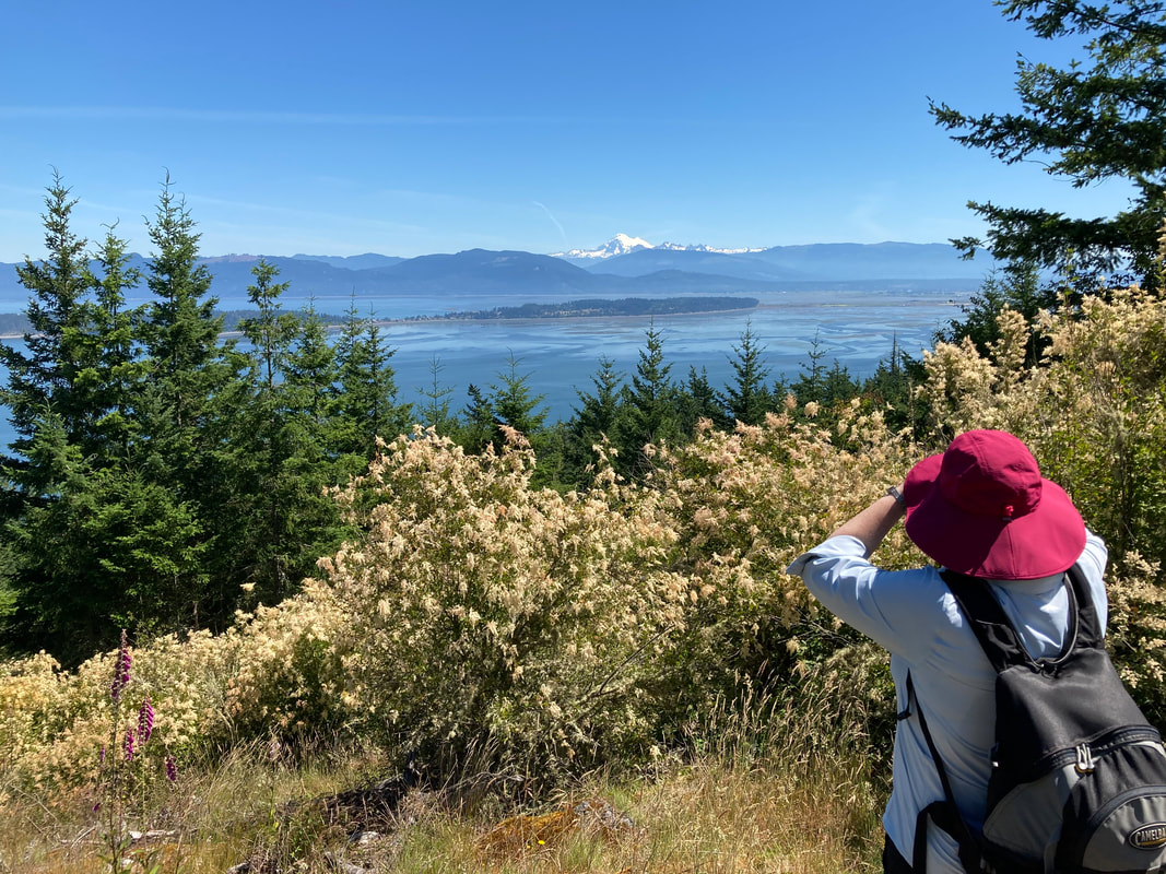
 It takes a village to save a mountain, or a beach, or a forest, and a host of volunteers to create a trail for everyone to use. In this case it took the Skagit Land Trust, the San Juan Preservation Trust, many generous donors and the Washington Trails Association with hundreds of volunteers to protect this mountain and build a 1.2 mile long trail to the summit. Though I was not involved I very much appreciate their efforts and generosity and want to thank them for their good work! This trail has been around for a decade but not many know about it. In fact, not many know about Guemes Island. This week I had the privilege of introducing my friend Kelly to Guemes Mountain and Guemes Island. It was all new to her. She had proposed a popular hike in the North Cascades but I talked her into this less crowded trail that’s closer to home. It was a hot day and I was looking for a shady hike with a view at the top. Guemes Mountain is just that. We started with breakfast in old town Anacortes and then went to catch the cutest little ferry from the corner of 6th Street and I Avenue. After parking under a nearby shade tree we walked down to the dock. A round trip ticket cost $5 and the crossing took 5 minutes. On the way I chatted with my old Anacortes neighbor, Kit who was heading to his art studio on the island. I remembered when I took my parents who were visiting from North Carolina on this ferry to have lunch at the General Store. We met George on the boat and he gave us a tour of the Island in his VW bus. I love small islands and small towns and small ferries. When we landed Kelly and I turned right and walked South Shore Drive 2 miles to the trailhead. It’s a flat road passing farmhouses with stunning views across the water. Only a few cars passed us and we had a relaxing conversation on the way. The last time I was here, my friends and I biked from the ferry to the trailhead where we could lock up our wheels at a bike rack before starting our hike. At the trailhead we found a charming interpretive panel with a map that said the elevation gain was about 600 feet. Just right for a hot day. Nearby was a post where several ski poles had been left for use as walking sticks. As soon as we entered the forest Kelly marveled at the lush ferns covering the hillside. I was happy for the tall forest canopy and shady trees. We zigzagged upslope listening to the calls of Swainson’s thrush, towhees and chickadees. Nearing the top we found a west facing overlook with an interpretive sign and a bench, a good place for a water break before moving on. Passing under a fragrant archway of ocean spray we reached the summit. It was bald and sunny with spectacular views and we spun around trying to figure out which island was which. There was Samish Island, Vendovi, Sinclair, Lummi, Cypress, Fidalgo and Mount Baker in the distance. Once we were oriented, we took the loop trail and settled in the shade where a soft breeze provided a perfect lunch spot. A sparrow hopped up expectantly. A few other hikers came and went but we mostly had it to ourselves. On our return trip we had enough time to get a cold drink at the General Store before catching the ferry back to town. If you've never been to Guemes, give it a try. For a map and details click here. For the Guemes Ferry Schedule click here. Maribeth Directions: From Highway 20 at the Sharpes Corner roundabout go northwest toward Anacortes and drive 5.3 miles. Turn right on R Ave which turns into Q Ave. Turn left on 6th Street and drive 8 blocks to the ferry. There’s free parking just east of the ferry.
Transit: If you’re coming from Whidbey Island, you can take fare free Island Transit Route 411W from Harbor Station in Oak Harbor to the March’s Point Park and Ride. Then catch the Skagit Transit Route 410 to the Guemes Island Ferry in Anacortes. If you’re coming from Mount Vernon you can catch the 40X bus from Skagit Station to March’s Point and switch to the 410 bus. Bring small bills for the Skagit Transit bus. *Two or three bikes fit on a bus bike rack. *Federal law requires masks on public transit including buses and ferries. Mobility: This trail is on a gentle slope, a well maintained trail but climbs steeply near the top. The summit has some rocky, uneven and sloping sections.  “The real miracle is not to walk either on water or in thin air, but to walk on earth.” – Thích Nhat Hanh In 1971 I came to the Fort Casey beach with my high school marine biology class. It was a warm sunny spring day, not a breath of wind. I dove into the rich biology of the seashore at low tide, finding critters common and rare, discovering how they live in such a demanding environment. I was at that age when hormones are rising, and my curiosity about the mystery of life was becoming attuned to the simplicity and beauty of nature. That weekend and that class changed the direction of my life forever. About that same time a simple novella came out called Jonathan Livingston Seagull, a Zen vision of life. That book also changed me as I learned to seek the beauty and potential in each of us. “For a thousand years we have scrabbled after fish heads, but now we have a reason to live - to learn, to discover, to be free!” Jonathan Livingston Seagull My goal this week was to visit Fort Casey and not see the fort or guns or history, but to return to the life of the beach, to reconnect with that boy of fifty years ago, and to find the miracles and beauty that today would bring. A gale wind cooled the warm day into a frigid evening, cutting through my layers of clothing. Waves crashed ashore from the long fetch of the Strait. At the crest of the bluff seagulls were riding the wing of the wind along the edge. I dropped down to the beach into the eternal battle between seagulls and eagles. I seemed to have entered into the middle of an ongoing dispute. An eagle hovered above me, talons out and descending slowly to the beach, while five gulls took turns diving on it and expressing their demand that the eagle leave, now. A couple crows added their pesky presence and voices too. Eventually the eagle climbed a little, turned with the wind, sailed over the bluff and out of sight. Amazing, I thought, as this all took place hardly twenty feet above my head. But the game wasn’t over. The eagle returned, as did the seagulls and crows, hardly inches above it at times, but not lingering there for long. Again the eagle came right over my head, dropped it’s talons and braced for a landing, only to change its mind, flick its head at the nearest complainant, and glide back up, this time stopping on the bank above while the other birds continued to harass it without ceasing. A minute later it disappeared over the bank. Yet again, it returned a few minutes later, still accompanied by its un-fan club, still focused on landing on the beach near me, and again giving up and flying away. I wandered up the beach, looking at kelp washed up by the rising tide and crashing waves. I turned and walked south, the wind and surf drowning out the songs of sparrows and blackbirds. At the south corner, schooling fish had attracted a horde of seagulls and cormorants. They dove and squawked and fluttered and pestered each other, sounding more like the seagulls in a much more recent movie, Finding Nemo, as they called out “Mine!” “Mine!” “Mine!” So much for Zen patience and cooperation. The sun was lowering, the wind increasing, the seagulls focused either on the hope of food or the joy of riding the wind along the bluff. Looked to me like they were taking turns doing both. I walked east, interrupting a killdeer that led me away from a nearby nest, then I headed up the bluff and followed it back to where I had started. I had enjoyed my reconnection with the life of the beach and headed to Oak Harbor for pizza. jack To see the aerial flights, go to https://youtu.be/hYev4pkBON4 Directions: From Coupeville, take South Engle Road to the ferry dock. Park at the lot to the east of the ferry and walk into the park, or take the main entrance road into the park just north of the ferry. Parking pass required.
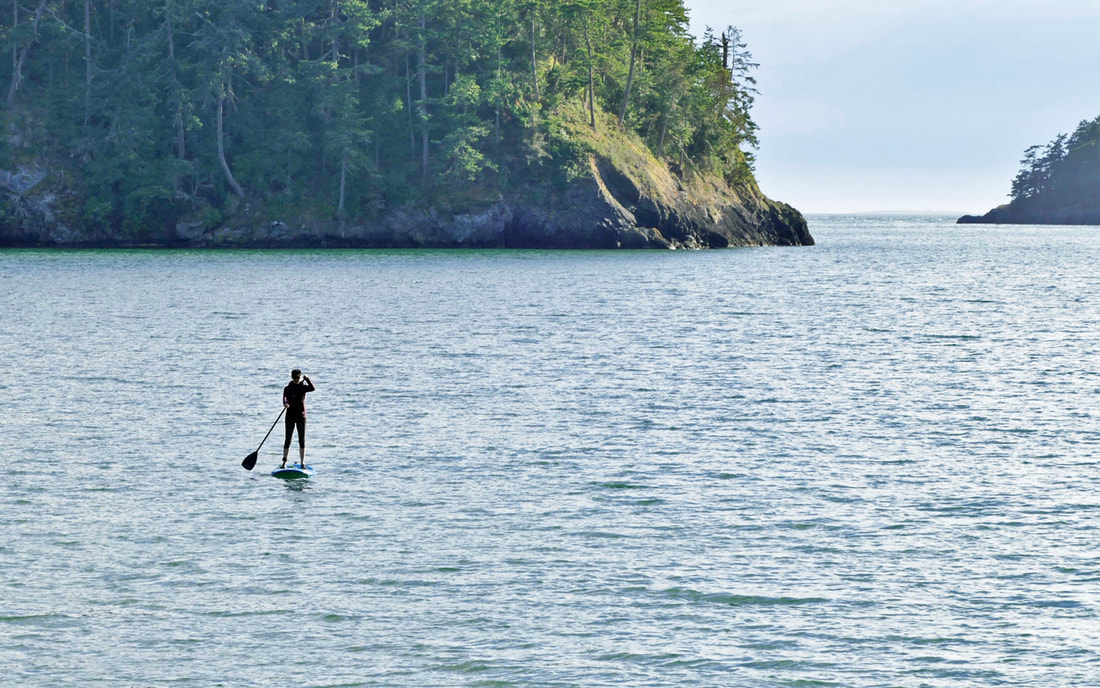
Transit: Fort Casey is accessible directly via Island Transit. Bike access: the roadways near here are relatively quiet for traffic with adequate shoulders and moderate elevation changes. Accessibility: Fort Casey has some accessible walkways and roadways. The beach is sandy, gravelly, and uneven. 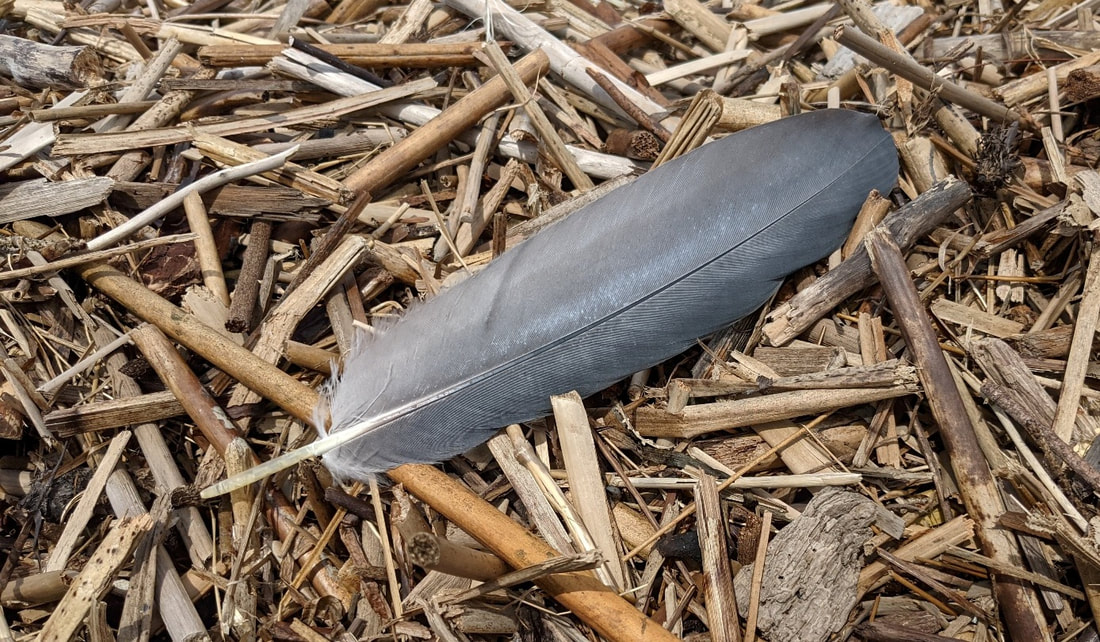 The last time I was at Ala Spit was New Year’s Day 2020, the beginning of quite a year. It was a king tide that day, and finding a path across the spit was a challenge to keep my feet dry and my body warm. I wrote then how New Year’s Day always makes me think of the song “Unwritten”, how the new year waits for us to write a new chapter in our life. “Life is short and the older you get, the more you feel it. Indeed, the shorter it is. I realize how important it is to use the time I have.” – Viggo Mortensen I was back this week. This time the current was racing out for one of the lowest tides of the year. The beaches were wide and spacious, the air warm, the sun sparkling on the water. I walked to the southern boundary first, past the kayak camp, then turned around to follow Ala Spit to its northern end. I always think I’m going to hike the spit fairly quickly, take maybe a half hour or so. It’s only a mile-long round trip. Then I get walking, and thinking, and something catches my eye and I check it out, and something catches my heart and I dwell on that, and then I view a crab or a fisherperson or a cute dog or a new flower or the sound of the tide running by or a memory of a previous visit or the way the wind plays with the grass or the smell of low tide or the taste of salt water or the feel of the wind on my face or a dream of sunlit waters dancing in my mind -- all these things filling my senses and my spirit and I lose track of time and find life instead. “Look at everything as though you were seeing it either for the first or last time. Then your time on earth will be filled with glory.” - Betty Smith Have you ever seen a feather fall out of the sky? As I moved north, I happened to look up. A feather was fluttering down out of the heavens. It landed near me, a gentle touchdown, and just lay there on the sand. I looked up and saw no bird flying above me. The feather was bluish-gray, a foot long, seemingly fresh from its most recent owner. I accepted this unusual gift, stuck it in my hat, and continued on. A fisherman waded out to look for sea-run cutthroat. A couple families walked by, enjoying each other’s company as they bantered, and enjoying the long-distance views. I counted the islands visible from here: Fidalgo of course, and Skagit, Hope, Kiket, Big Deadman, Little Deadman, Goat, Ika, Dot, and Sugarloaf. That’s a lot of islands seemingly a short flight away. Driftwood forts sprouted like urchins or mushrooms all across the spit. Flowers were bursting their flavors and beauty too, growing in clumps of yellow or pale lavender or white or plain green. The warmth brought out their scents and made the air intoxicatingly delicious. I rounded the point and headed down the west side, quite different from the east side. The east is busy with the currents and waves, the west silent and time stands still; the east is gravelly and sandy, the west mostly muddy; the east looks far and wide, the west close and personal. I stood in the mud and watched crabs scurry for shelter as the water receded even lower. They know the routine: escape being exposed to the air during low tide, exposed to predators and the desiccating sunshine and heat. Soon I was back at the parking lot; well, not soon. It was two hours later. Once again Ala Spit had absorbed my time, time well spent. “The butterfly counts not months, but moments, and has time enough.” - Rabindranath Tagore jack Directions: On highway 20, 6.5 miles north of Oak Harbor, take Troxell Road east four miles to Geck Road (you'll see it as soon as you get near the water) and drop down to the parking area.
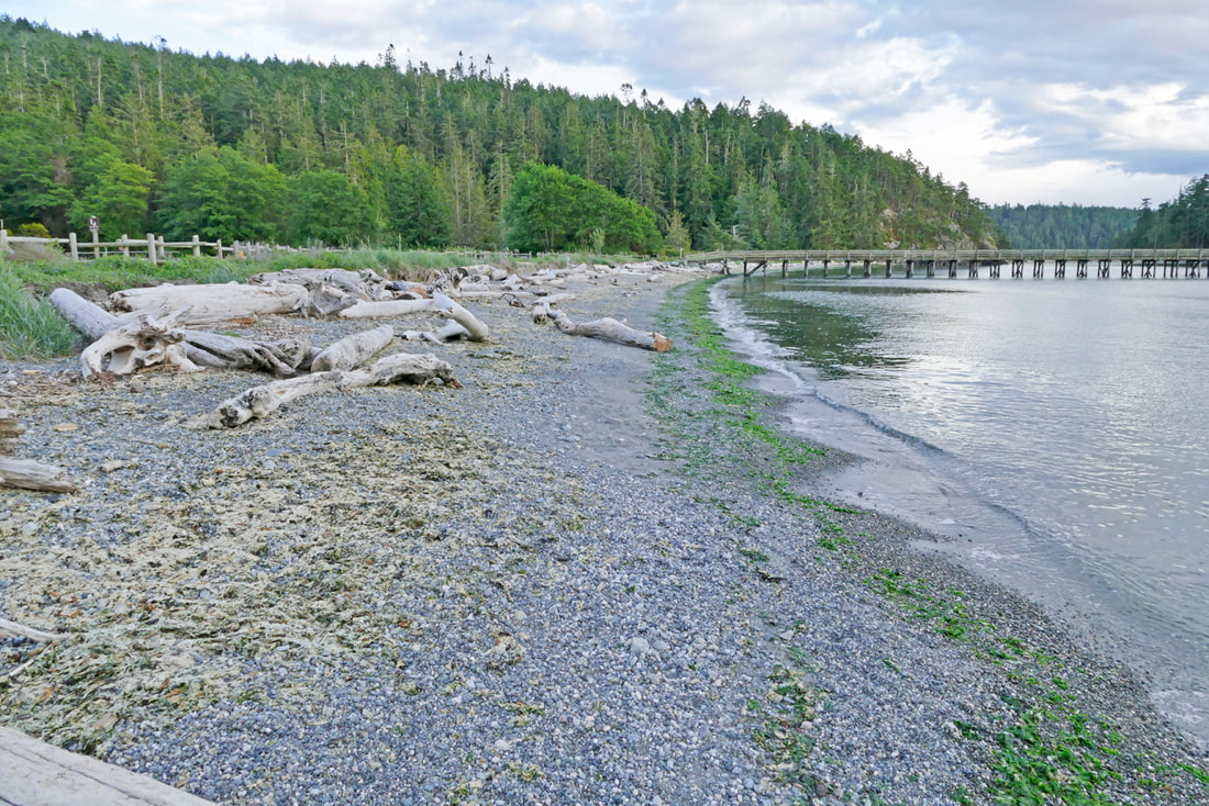
Transit Accessibility: not accessible Accessibility: the parking area is right at the beach. However, the trail is strewn with logs, and getting to the beach requires clamboring over more driftwood. Bike Accessibility: difficult on Highway 20; Troxell Road is quiet, though hilly and with narrow shoulders.  What we have today is not what has always been, nor what will be in the future. The youth among us only know what they see today, crowded highways, sprawling towns and subdivisions, a culture mostly separated from nature, as we gaze 18 inches into a screen. Many of us are old enough to remember how Whidbey and Fidalgo used to be 60 years ago. We are not yet old enough to remember what it was like 600 years ago. Our native elders do from the stories they heard from their ancestors. Bowman Bay was home to many. The bay offered safe waters to launch hand-made canoes out into the nearby fishing grounds. Fresh water flowed from the lake in winter. Berries and bulbs grew on the headlands. Then European diseases diminished the population by perhaps 90%. The federal government reserved Reservation Head on this side of the pass for a future fort. State Parks changed the bayside area into a campground. CCC enrollees built trails onto Reservation Head, and a little footbridge over the wetland at the south end of the bay. Then the Fisheries Department changed the wetlands into a fish hatchery, and put a pier, a rockery, fish tanks and buildings where there once was beach and nearshore habitat, where canoes once rested after a day of fishing. I came here with my family sixty-plus years ago and walked among the fish tanks, above the rocks, and along the pier. I came back in the early Seventies and walked among the ruins of the tanks, now a rough parking lot, but with the pier and riprap still at the water’s edge. That changed in 2015, when the beach became a beach again. Today, driftwood has returned. Fish eggs are again found among the sand and gravel. Families build driftwood forts and skip rocks and stroll the seashore at sunset. I close my eyes and envision tribal members launching out to find salmon. I open my eyes and a paddleboarder returns to shore, kneels and steps ashore. I hike past the pier, closed because of storm damage, and stroll down the Lighthouse Point trail first built by the CCC. The footbridge across the wetland has been replaced over the years, but it’s in the same place, doing the same thing. The trail climbs the bluff and goes past a handrail built by volunteers around 2007. Then it drops down to the soft sand of Lottie Bay before sneaking onto the backside of Reservation Head. The views open up on the south side, first of the bridge getting sandblasted to be painted, then of the entrance to the Pass, then out to the Straits toward the ocean. I came to the little pocket cove as a teenager during spring break, and watched the sun rise as I snacked on Toblerone and soybeans. The cove looks the same to me now, the trails gentle on the land, the air rich with the smells of the sea, the sound of the waters quiet and constant as the water flows by. I walk to the view of Lighthouse Point, then out to Reservation Head to watch the sun go down once again, as it has for millennia, putting Rosario Head into silhouette and the day into dusk. The world around us is changing daily. Our lives become comfortable with our riches, but our planet is becoming impoverished for what truly sustains us: clean air, clear water, healthy plants and animals, stable temperatures, and balanced use. We have protected places like Lighthouse Point, like many of our trails close to home, that showcase how it used to be, how it can be. These trails lead us as visitors through the wildlands, through the homes of other life forms who struggle to share this planet with us. And in our visits we remember what we have lost. And work harder when we get home for the future of us all. jack Directions: from the Deception Pass bridge, go north, turn left at Rosario Road, and another left quickly onto Bowman Bay Road. At the 'T' take a left which leads to the Bowman Bay parking area. The trail begins on the southwest side of the parking lot. Parking pass required.
Transit Access: Not accessible by transit. Physical Accessibility: the gravel trail from the parking area goes about a quarter mile flat, level, and wide. Then it climbs steeply to get past the first bluff. Bike access: Highway 20 and Rosario Road are both high speed and high volume with minimal shoulders. I do not feel safe riding in this area. |
Authors
Maribeth Crandell has been a hiking guide in the Pacific NW for over 20 years. She's lived on Whidbey and Fidalgo Island for decades. As a frequent bus rider she easily makes connections between trails and transit. Archives by date
July 2024
Categories
All
|


 RSS Feed
