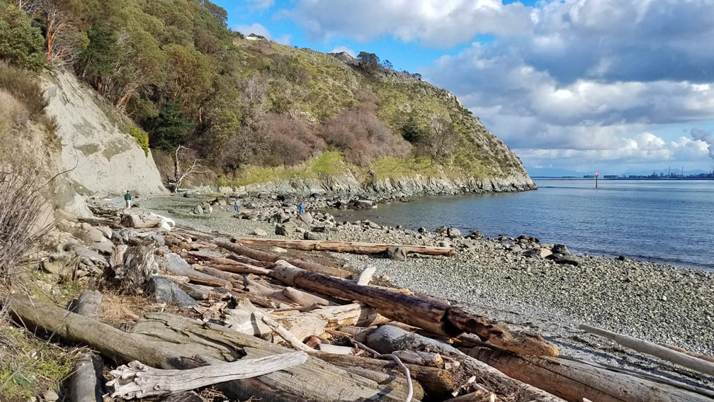
 With a little time to play and a sunny afternoon in Anacortes, I knew where I wanted to explore: Cap Sante, the popular viewpoint overlooking the harbor and city. But I wanted to experience it from the bottom up, earning the view from the top by starting at the shoreline of Rotary Park. I parked at the north end of the harbor in the parking area for Rotary Park – thank you Rotary! -- near the Anacortes Yacht Club headquarters. I strolled the paved walkway southward along the water’s edge, passing several dog owners happy to let their best friends wander the walkway with them, exploring the new smells of spring. Along the water’s edge, hooded mergansers chattered away in a personal conversation. Toward the bluff, the disc golf course opens up the forest that once hid in ivy and mystery. In just over a quarter mile I arrived at the south end of the park, where a small shelter, benches, and several picnic tables invite your use. I walked down to the water’s edge on the south, and looked up at Cap Sante rising a couple hundred feet above the beach. Deer trails traverse the southwest facing slope, not maintained and certainly not generally safe for human use. The slope is covered in rows of rose bushes, repelling foolhardy attempts to penetrate through, and slippery grass meadows scattered among the bedrock of the headland. Occasional piles of litter cast off from the parking area above spoil the slopes of this city park. At the top, of course, the views are stunning, with Baker rising above Guemes and Hat Island on a clear day, the steam stacks on March Point to the southeast with oil tankers waiting in line to unload, and the town of Anacortes nestled along the shores of Fidalgo Bay, leading to views westward over the San Juans beyond. A hundred years ago or more Cap Sante was an island at high tide. A “duck marsh” separated the headland from the center of town. Early pioneers recognized its park and recreation values, and purchased it from the Bowman family, one of the founding families of Anacortes. The town was named after Amos Bowman’s wife, Anna Curtis Bowman. The headland was named by Anna for a landmark of her childhood days in Quebec, Canada, also called Cap Sante looking over the St. Lawrence River. In my humble opinion, the beaches of the original in Canada share some similarities with ours, but the headland in Anacortes is far more dramatic and awe-inspiring. Returning back to the car led me to more dogs taking their owners on a walk, cherries flowering near the water’s edge, a couple people enjoying an intimate lunch on a picnic bench, and several more on other park benches resting and soaking up the sun as the spring-like air filled us all with joy, health, and hope. Cap Sante is French for Cape Health. Directions:
From Highway 20 entering Anacortes, take the R Avenue exit, which turns into Q Avenue. Drive to the end at 4th Street and turn right. Turn right again at T Street and drive to the end of the road, angling left at the oddly configured five way intersection. Park in the large lot next to the paved trail.
0 Comments
 Bosky, adjective.
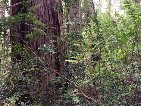
Last weekend my niece was visiting so we took a hike at South Whidbey State Park. As we shouldered our packs, I pointed out the interpretive sign at the park entrance, right next to the bus stop. The sign showed images of some local people who stood in front of the bulldozers, back in the 70's, to protect these giant trees from logging. Some of them still live in this community and still take care of this park. Thanks! We crossed the road and took the Ridge Trail zigzagging gradually up a hill through the woods. She set a slow pace, looking around her, silently studying her surroundings. She had lived in Tennessee, Texas, Washington D.C., Ohio, Utah and recently moved to Seattle. As I watched her, it occurred to me that this might be her first time in an Old Growth Forest. She walked slowly taking it all in and stopped to take pictures whenever she saw trees growing out of stumps. I taught her about the different trees and picked up cones to compare and contrast. I told her the story about the little critters with their heads tucked into Douglas Fir cones hiding from ancient forest fires. Their big buddy Doug would protect them with his deep, corkey bark. She spotted several large trees with burned sides that she guessed were Doug Fir. The spiky Spruce needles contrasted with the soft paper petals of their cones and their potato chip bark. We compared the needles of Western Hemlock and their varied lengths with the Grand Fir needles which are all the same. She realized when I spoke of Big Leaf Maple that it was the trees’ name, not just its description. But I wasn’t the only one doing the teaching. She taught me a new word. Bosky, a wooded area, with lots of trees and shrubs. I’d never heard the word before. She informed me it comes from the Middle English and is related to the word bush. The word dates back to 1616 and fell out of use for a while, but perhaps is currently experiencing a comeback. It has a rotten wood, mossy bank, prickly thorn sort of quality to it, much like South Whidbey State Park. We walked from cloud to mist to pitter patter and back again as we traversed the Ridge Trail with its Alder wood and muddy track. Descending to meet the Wilbert Trail the trickle of small streams and emergence of the first pink salmonberry blossoms were delightful. She stopped short to study a Douglas Squirrel which studied her, too. We wove through huge trees and were led to the Ancient Cedar by a trail of red rose petals from someone’s Valentine. Crossing the road again we passed my favorite tree in the park, the Hobbit House with room for a whole family inside. The damp green radiated throughout the forest with early shoots and unfurling fronds emerging with new life. As we neared the end, I asked what highlights stood out to her. She was amazed at how the death and decay contributed to the up-welling of new life. The nurse logs, snags, and her favorite, nurse stumps, provided peat pots for new plants and homes to so many animals. I was honored to introduce her to this Old Growth landscape. It’s been 40 years since I came to know Old Growth. Thanks to her visit I saw it with fresh eyes and now call it by a new name, bosky! For Directions:
Coming from South Whidbey, take Highway 525 just north of Freeland and turn left on Bush Point Road which turns into Smuggler's Cove Road. The park is 6 miles from Freeland. If you're coming from north Whidbey, drive toward Greenbank on Highway 525 and turn right on Smuggler's Cove Road. Continue for 5 miles to the park entrance. The Route 1 bus will bring you right to the park entrance Monday through Friday but there is no bus service here on weekends. *For those with mobility challenges, the paved campground road may be a place to explore the forest. The campground is closed by a gate but power wheelchairs can access the campground to the left of the restrooms. Be aware, the road is hilly. 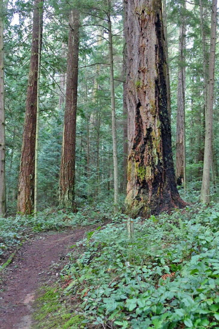 “The common eye sees only the outside of things, and judges by that, but the seeing eye pierces through and reads the heart and the soul.” ― Mark Twain I confess. I have on occasion spoken disparagingly of the Heart Lake trail, even in a trail presentation. Some trails are attractive at first glance because of their obvious beauty. Some reveal their qualities more slowly as their soul becomes revealed step by step along the way. Those kinds of places can surprise you in unexpected ways. So I cast aside my previous somewhat bland experiences on the trail and looked for the heart and soul of the place, not with my eyes as much as with my own heart and soul. My challenge was to fall in love with the Heart Lake trail. I decided to also sweeten the deal by offering chocolate bars to anyone I met on the trail if they would share with me their feelings about the trail, whatever they may be. I followed trail 210 counterclockwise from the Heart Lake parking area, as usual. A beaver dam had raised the outlet even higher, creating a waterfall at the northernmost point of the heart shape of Heart Lake. Recent deluges have turned the trails muddy throughout much of the trail, so I skittered around some of the bigger puddles. A two-foot diameter tree across the trail early on required getting low to get under – while dodging the mud. I ambled down a side path to the lake and found Sugarloaf rising above like an old friend at home. The trail then enters a fern and fir grove, but this time I just stood in the grove to listen, to smell, to sense without my eyes. The air was pungent and clean; kinglets and wrens shared tweets with those unplugged and in tune. I noticed that the bare maples in winter allowed light to fill this glade with afternoon sunshine that is muted by their leaves in summer. Around to the south the trail gradated into a new experience. Brown needles covered a rock and dirt trail, no mud. Bedrock emerged. Trees changed from mixed woods to dense Doug firs. Passing the south marsh, the trail rose into a cathedral of ancient monarchs that instill reverence as you pass. Fire scars climb most of the old ones. I pictured the inferno that had in the not too distant past raged through these woods where I now stood. These trees stood against the fire and now stand with scars as a testament to their enduring strength. I stood in their presence, awed by the quiet, by the majesty, by the centuries of life towering all around. I had planned to explore trail 212 to see the views to the south and make a double loop; or to cross the road and follow 320 and 313 back to the parking lot as a complete loop to avoid retracing my steps on 210. But I wanted to return on the trail I had just hiked, with a new-found interest in its hidden treasures. I was intrigued with my discovery of some of the soul of the Heart Lake trail, some of its heart imparted to my soul. As I retraced my steps clockwise around the lake, I was passed by the first person I had seen throughout my hour and a half excursion – but she was jogging, and probably not interested in stopping to answer a question, not even for a chocolate bar. As I returned to where I started, I realized I had been changed, seeing with new eyes the joy of the Heart Lake trail. (So having now shared some of my feelings about the trail, I feel I have earned a candy bar for myself. What a sweet deal!) jack Much of the Heart Lake area was saved from logging due to its long-time protection as part of Deception Pass State Park. When it was transferred to the city of Anacortes in 2002, one of the stipulations was that the area continue to be managed as the state park had envisioned, with no development or tree harvesting. That protection continues with the strong leadership of Anacortes City Parks and our community support.
Directions: From H Avenue in Anacortes, take Heart Lake Road south to the parking area at the lake. From Whidbey Island, follow Highway 20 north across the Deception Pass bridge, drive north about four more miles and turn left on Campbell Lake Road. At the Lake Erie store turn right onto Heart Lake Road. 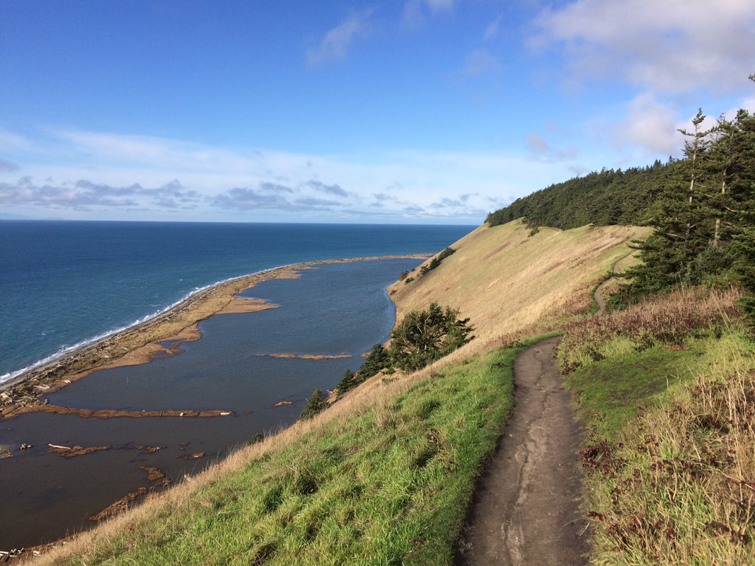 I love football. Super Bowl Sunday is an excellent day to take a hike on the most popular trail on Whidbey Island. A strong wind blew the clouds away and unveiled a brilliant blue sky. So off I went with my lunch and a thermos of tea. There were far fewer cars in the parking lot than I’d normally see on a sunny weekend. I cheered the football gods for distracting so many people on this spectacular day. I needed this dose of sunshine. The steep climb was invigorating. As I hiked I met dog walkers, joggers, and visitors, as well as locals. Everyone wore a smile. People often ask me, “What’s your favorite trail?” I think most of us would answer “Ebey’s Bluff”. It’s one of the most stunning places in Puget Sound. I feel blessed to live nearby. But my relationship to this trail has changed over time. I’ve lived on Whidbey for over 20 years and have visited the Bluff in every season, alone, with guests, in celebration, in grief, with sun baking my shoulders, or a cold wind on my face. I’ve seen whales moving just off shore, stood eye to eye with eagles, watched hard working tugs, cruise ships, ferries, sailboats, even hang-gliders from here. On a clear day I've seen Mount Rainier, Mount Baker and Mount Olympus and I know I'm in the center of the universe. Still, I’ve changed, and the trail has changed, and the people that come to walk the trail have changed. It’s an ever evolving relationship between people and places. When people ask, “What’s your favorite trail?” they’re probably expecting me to say, “Ebey’s Bluff”. But I’ve walked the Bluff on days when there are too many tourists and I feel like an outsider. I’ve seen people try to drive their cars along the Ridge Trail out to the Bluff. I’ve seen cars parked all the way up Hill Road and the beach flooded with visitors. Our feet tear at the grasses. People getting off-trail on the soft slope can do a lot of damage. On those days, Ebey’s Bluff is not my favorite trail. It’s in danger of being loved to death. Then again, I think it’s nothing short of miraculous that we have this trail and that it’s so well-tended. Ebey’s Landing National Historic Reserve is a unique partnership of our National Park Service, Washington State Parks, Island County and the Town of Coupeville. We see this trail as one 5 mile loop, but it crosses different properties owned by different jurisdictions that work together to maintain it and allow us access. There are restrooms, interpretive panels, stairs, fences, plowed fields, wind whipped forests, beaches, lagoons and it all makes up this spectacular place. Property was donated by private land owners, bought by non-profits and government agencies to make up the whole. Neighboring farmers signed easements to preserve the prairie that remains very similar to what early pioneers saw 150 years ago. It took decades for all this to come about and it keeps expanding. I’ve heard stories of how close it came to becoming another row of waterfront condos and Joni Mitchell’s song comes to mind, “You don’t know what you’ve got till its’ gone.” The natural and cultural history of this place is significant but there’s far more to this story than can be told here. The Jacob Ebey cabin along the Ridge Trail houses interpretive exhibits and is staffed by volunteers in the summer and on holiday weekends. You could also read about it on trail side interpretive panels, partake in a park program, or study their website. Suffice it to say that Ebey’s Landing National Historic Reserve has done us all a great service in preserving this place and allowing us access. Hopefully, we’ll be able to preserve this cherished place for generations to come. Mb Directions:
There are two entrances to the Ebey's Bluff Trail. Coming from the Coupeville Ferry on Engle Road, turn left on Hill Road which leads to the parking area on the beach. Or take Main Street south from the stop light in Coupeville, which turns into Engle Road. Turn right on Hill Road to park at the beach parking area. Bring your Discover Pass or park along the road. Or from Highway 20 just north of Coupeville, take Sherman Road south to Cemetery Road and park at the end of the lane next to the offices of Ebey's Landing National Historical Reserve. Taking this route you'll pass the historic Jacob Ebey cabin and blockhouse. The Ebey family and other early pioneers are buried at the Sunnyside Cemetery on Cemetery Road. For a map and more details visit: www.nps.gov/ebla/planyourvisit/upload/050514-Trails-Map.pdf |
Authors
Maribeth Crandell has been a hiking guide in the Pacific NW for over 20 years. She's lived on Whidbey and Fidalgo Island for decades. As a frequent bus rider she easily makes connections between trails and transit. Archives by date
July 2024
Categories
All
|
 RSS Feed
