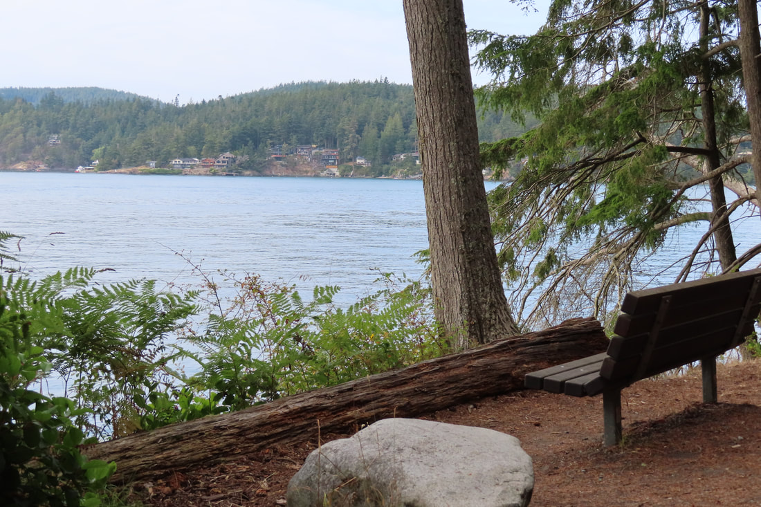
 When I gave my first book release party for Hiking Close to Home in September of 2019, I showed images of over 50 trails and spoke of experiences I’d had on each one. At the end someone asked, “What’s your favorite trail?” As you can imagine, I get that question a lot. It changes with the weather, my energy level, and if I'm alone or with others. My answer that day was Hoypus Point. It’s a little known trail at Deception Pass State Park. I explained that years ago when I lived in Anacortes and worked in Oak Harbor, I commuted over the bridge by bus almost daily. But when I had breast cancer and was undergoing chemo, I opted to drive. When I approached the park at the end of my work day I would crave a walk in a peaceful natural setting but my energy level was low. Thinking through the options, Hoypus Point was often my trail of choice. It’s just a mile long, paved, flat and quiet. It was once a road to an old ferry dock. But when Jack Hartt was the park manager, he closed it to vehicle traffic. That made it a wonderful walk for people, especially people like me, people without much energy, people with mobility issues, or people who just want a relaxing walk on a quiet road with views of the water. Hoypus Point is a well kept secret. Last Saturday I was coming back to Whidbey after a long laborious day on the mainland. I'd planned to meet Jack for a picnic dinner and attend a concert at the park amphitheater. But I was an hour early. The bridge was swarming with tourists parking alongside the road and leaning over the water taking selfies. I inched through it all and then turned left at the light. Driving to the end of Cornet Bay Road I encountered the same frenetic activity around the marina and the boat launch. It’s August in the most visited State Park in Washington and the salmon are running. But I found a place to park in the back corner among the boat trailers. At the trailhead I passed through a gate. It was as if I’d entered Narnia. There was no one in sight. Walking slowly the hustle and bustle of cars and trucks, boats and trailers faded away. I noticed the cow parsnip in bloom, the cedar waxwings calling from the tree tops, the shimmering blue water through the branches of the madronas leaning out over the beach. An elderly woman with a walking stick passed with her dog. A young couple approached on bikes with a little girl trailing behind. "They should wait for her," I thought. But when she passed me she was cheerily singing to herself, happy to be on her own. Then I was on my own all the way to the end, stopping to look back at the bridge and listen for birds. At the end of the old road I looked out over the water and realized I could see some of the other hikes in our book. There was Mount Erie to the north and directly east was Flagstaff Point at Kukutali Preserve. I sat quietly and was visited by a chipmunk for a moment. Then it dashed off like a shot. A private little beach lay just beyond the road end but high tide hadn’t left much wiggle room for exploring. Then I heard voices quite close. Along came a group of kayakers a few yards from shore. I turned and walked alongside them back to the trailhead, they moving silently in the water and me slipping quietly through the trees. I passed a few more walkers on my way out, but the crazy activity of the bridge and the boat launch had left Hoypus Point unscathed. And that is why one of my favorite hikes is still Hoypus Point. Let's just keep that to ourselves, shall we? Maribeth PS Here's a map of the park. Directions: Just south of Deception Pass Bridge turn east at the light onto Cornet Bay Road. Drive 1.5 miles to the end and park near the boat launch. The trail continues east for 1 mile on the old road.
Mobility: This old paved road is mostly flat and offers an opportunity for people with mobility challenges to enjoy a walk or roll in a beautiful natural setting. Transit: Island Transit stops at the intersection of Highway 20 and Cornet Bay Road. It is a mile and a half from there to the trailhead. 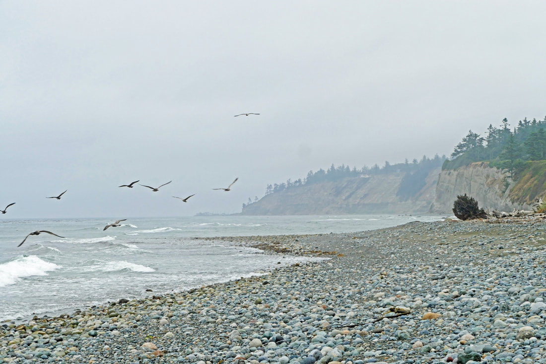 The sound of heavy surf. and nothing else. Waves roll on in then wash back out then another and another And they follow each other in a never-ending dance breaking on in washing back out and there is no other sound to be heard. Hiking from Hastie Lake Beach to West Beach County Park gives a two and a half mile walk each way. It’s a walk like no where else on Whidbey. Once you get past the handful of houses intruding into the shoreline next to the parking area, you enter a remote seashore with a waterline that faces Japan to the west and bluffs two hundred feet high to the east. You have entered a beach world separate from the rest of the island, isolated and alone and close to the wild heart of Whidbey. The first half mile is a challenge to walk. The beach is made of rocks; it’s like walking on a field of flat soccer balls. The concrete-colored bluff composed of glacial till rises straight up here. Rounding the first point to the north, the bluff changes to a softer texture with a blanket of grasses and trees. The beach, too, begins to change, the rocks becoming more of a gravel mixture, easier to negotiate. Further on, the bluff changes again, becoming clean layers of clay. Chunks break out from time to time, tumbling to lie at the bottom until washed away. The beach becomes pebbles and sand. Then the bluff changes dramatically into castles of sand, eroded into canyons and pillars that sometimes spill and slip and slough down the bank. Here the beach changes into a hard-packed sandy strand that beckons you to remove your shoes and hike barefoot along the water’s edge. This sand continues almost all the way to West Beach, where the bluff morphs back into glacial till and the walking again becomes a cobbled challenge. Time your hike to fit the weather and tides. Any tide of only 4 feet or higher will make the initial rip-rap wall at the Hastie Lake parking area nearly impossible to get past without becoming a bouldering expert. And for the entire stretch, make sure you aren’t trapped by a very high tide, or you may find yourself between the bluff and the deep blue sea with no beach to walk on. I had started at West Beach on a medium high tide the evening before, but a fresh sandy landslide a half-mile down buried the beach down to the water’s edge, blocking me from going any farther. I rose early the next day to start at the Hastie Lake side to be ahead of a rising tide. So did a heavy fog, dampening the day, softening the skyline, and muting all sounds of civilization. Throughout the hike I heard very little other than the constant rhythm of the surf, following me my entire way. An eagle watched me from above; a hawk circled the trees elsewhere. Pigeon guillemots played musical chairs on a rock offshore. And gulls did their best to create some murmurations, but those broke down into individual dancing and flying and circling and resting again. I turned around when I got to the landslide from the day before. Waves had cut through most of it already, spreading it out across the beach. The fog began to rise as I walked back. This seashore is alive, removed from the rest of Whidbey, remote and relaxed, a world apart. As I drove home, long after the sound of the surf had faded, the memory of my walk on the wild west side of Whidbey remained within. This beach makes me feel this way every time. And the dance never gets old. “To sit in silence at the shore, watch the waves and hear the surf, is to appreciate the very breath and heartbeat of the earth.” – Doe Zantamata jack Directions: from Highway 20, 4.4 miles south of Oak Harbor or 6.4 miles north of Coupeville, turn north onto Hastie Lake Road and drive to Hastie Lake Beach Park just off West Beach Road.
Transit: West Beach Road is served by Route 6. Contact Island Transit for locations and times. Bicycle access: The roads getting to West Beach Road from Highway 20 can be narrow and hilly, but traffic relatively light. Accessibility: The beach is very challenging to walk on at both ends. The parking areas offer good views of the beach and the strait. 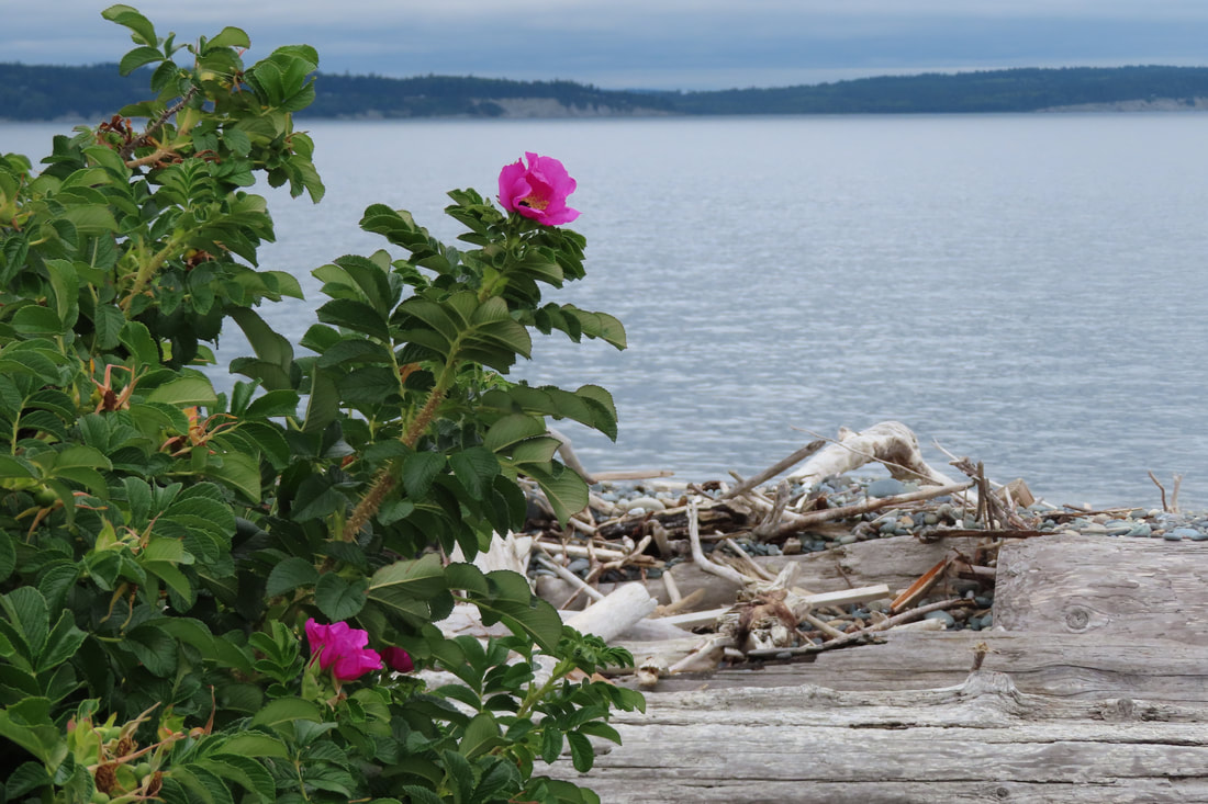 It was Saturday and I needed to deliver 25 of our hiking books to the gift shop at Fort Casey State Park. I take the bus often to reduce my carbon footprint. I think of it as a fun challenge. On weekdays the Route 1 bus goes straight up the highway to Coupeville, but on Saturdays, the Route 1 goes to the Coupeville Ferry and right by the park entrance. I wouldn't have to change buses! So I hopped on the bus with my box of books. On the way I thought about my upcoming blog post. Fort Casey, Camp Casey, and the Admiralty Inlet Preserve are all within walking distance. But I decided on Keystone Spit which is right on the bus route. The two mile walk would be perfect timing to catch the bus home. After delivering the books to the park office, I followed the campground road down the hill, crossed the ferry holding area, and walked east toward the busy boat ramp. I could tell by the number of boat trailers in the parking lot that it’s fishing season. I passed a nice restroom where divers were preparing to explore the underwater park. They can dive around the breakwater or the old pier which was once part of Fort Casey. The pier is often crowded with cormorants, excellent divers in their own right. Moving down the beach there were families beach combing and people walking their dogs. Cabins and castles were built using local materials, complete with furnishings and flagpoles. Fishermen stood evenly spaced, casting and reeling in hopes of winning a flashing silver prize. One old expert sat among the driftwood observing as if assessing the techniques of the others. As I moved from the beach to the old rugged road in the middle of Keystone Spit I stopped to read an interpretive sign telling the story of how this spit was slated for development. They called it “Chicago” on a plat recorded in the 1890s. The line of pilings on Crockett Lake across the road supported a bridge to the proposed town site. The hopes of a nearby railroad never materialized and neither did the town. Later, in the 1970’s, developers proposed 200 houses be built on the spit and two model homes were constructed. But local opposition that continued for years ended when Keystone Spit became part of Fort Casey State Park. Those two homes, battered by winter storms, provided homes for birds and wildlife. I was watching in 1988 when the remnants were torched by local firefighters for practice. Just across the road from Keystone Spit is Crockett Lake, an estuary with a mixture of salt and fresh water. The salt water of Admiralty Inlet, the sand bar of Keystone Spit and the brackish water of Crockett Lake makes this rich bird habitat. It meets the criteria to be an official Important Bird Area. Several species of raptors, shore birds, gulls, ducks, cormorants, herons, finches, wrens, blackbirds, swallows, sparrows and martins all find food and shelter here. In summer enormous white pelicans can be seen at the west end of the lake. An observation deck provides a little height where one can set up a spotting scope to spy on the birds from a distance. Continuing to the east I came upon two small ponds where I’ve seen a variety of ducks take shelter during winter storms. The Whidbey Camano Land Trust has a fundraiser going on involving biking around the lake and Ebey’s Prairie with a pie as a reward. A friend and I planned to participate the next day. I saw several cyclists passing by which made me wonder if they would also be eating pie in the near future. Find out more here: https://www.wclt.org/get-involved/bikeride/ At the eastern end of Keystone Spit is Driftwood County Park. You can park here without a Discovery Pass, but if you park on the old road in the middle of the spit, you will need one. Or you can take the bus as I did. For a bus schedule visit: www.islandtransit.org or call 360-678-7771. Maribeth PS: To help keep Keystone Spit clean volunteer with the Beach Litter Clean-up Program. Visit: https://extension.wsu.edu/island/nrs/beachlitter/ for details. Directions: From Highway 20 and Main Street in Coupeville, turn south and follow the signs to the ferry. Keystone Spit is just east of the ferry terminal. Walk the beach passing a few homes and then you can walk on the old road in the middle of the spit. Or park on the old road in the middle of the spit. You will need a Discover Pass as the spit is a State Park. Or drive to the east end of the spit and park at Driftwood County Park and walk west.
By Bus: The fare free Island Transit bus stops at the Coupeville ferry terminal and you can flag down the southbound bus at the east end of the spit. There is no Northbound bus stop there. Call 360-678-7771 for details or visit: www.islandtransit.org for a schedule. Take the Route 1 on Saturdays and the Route 6 on weekdays. There is no Sunday service. 2-3 bikes fit on each bus bike rack. Masks are required. Mobility: The old road in the middle of the spit is flat but the pavement is rough. The beach is mostly cobblestones and steep at high tide. By Bike: There's a wide shoulder on the highway along Keystone Spit. Riding the five miles around Crockett Lake is a very popular route among cyclists. 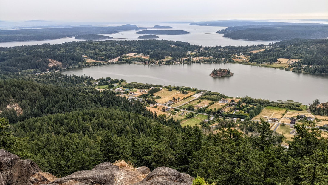 The runner is rewarded with the tape at the finish line. You are rewarded with the view at your feet. Terry and Renny Russell, On the Loose August 1. It’s early morn. Clouds hang low. A handful of raindrops speckle my windshield. I drive to Whistle Lake’s trailhead; I see just one other car. Signs nailed to trees say “High Fire Danger – No Smoking, No Fires”. It’s a tinderbox out here. My goal is to hike to the top of Mt. Erie from Whistle, to celebrate the new day and new month, and to honor a friend who had passed away just yesterday morning. I hike to the lake, muted in the overcast gray before sunrise. Doesn’t look like there will be a sunrise today. Squirrels in treetops chatter with others nearby. As I stop to listen, something falls with a loud thunk close to me -- a Doug fir cone. Then comes the noise of something else falling through the branches, and another thunk. That cone just misses me. I move on. I hike along the lake, climb up to Trail 21, follow that a short while, then turn west on Trail 207. It drops a little, then quickly begins climbing the east side of Mt. Erie. I hear a nuthatch. A Bewick sings. Then an owl asks who is cooking. Then another, a juvenile, screeches a plaintive wail of hunger. Then more cones fall through the tree branches, landing nearby like a bombardment from above. I move on again. The trail climbs steadily through the lower woods, through lush sword ferns and firs and maples. But soon I begin to notice that not all is lush. Many of the salmonberry leaves look like green potato chips, shriveled on their branches. Indian Plum leaves have turned mostly yellow. Fallen maple leaves litter the trail and forest floor. I keep climbing. Trail 207 meets Trail 216, where a decrepit sign hints at directions. The trail is level for a while, a pause before climbing the mountain in earnest. Soon I am scrambling up rock faces, stumbling up steps of tree roots, always going up and up and up. Beads of sweat dampen my shirt. I stop to drink water – lots -- to lighten my pack. I now regret carrying an extra sweatshirt in my pack. Just in case, I had reasoned. Just more sweat, I now realize. I reach the trail’s meeting with the paved road coming up the other side, then climb even steeper sections of the trail as I begin the final quarter mile of ascent. Beside me are boulders covered in the curled brown fronds of ferns, looking dead. More green fir cones fall from above. I climb a hundred feet up on a trail made of rock faces, drink more water, then enter a green valley. Now I know I’m getting close. I look for it, and a minute or two later I see it: a sign on a tree that says one simple, glorious word: summit. This peak is the highest point of land of all the hikes in our book. The final stretch is over quickly. I emerge at the Mt. Erie parking lot, then walk to the view out over Campbell Lake, over the islands in Skagit Bay, over Whidbey, over Rosario Strait, and over where the Cascades and Olympics should be except they are hidden in clouds and fog and smoke. I smell smoke. A cool breeze wicks through my shirt and chills me quickly. I put on that sweatshirt in my pack, glad I carried it now. I watch the day begin. A new day. A gift we all have, if we are alive. A day to keep alive the memory of those no longer here, and to treasure the gift of those who are. I raise my hand in memory of my friend. It’s time to go back down. And watch out for falling cones. jack Directions: From Whidbey Island go north across Deception Pass Bridge to Sharpe's Corner roundabout and turn NW toward Anacortes. From Mt Vernon take Highway 20 west and straight through Sharpe's Corner roundabout. At Commercial Ave. in Anacortes, take the roundabout south up the hill to Fidalgo Avenue where the road comes to a T. Turn left, or east, and go to the stop sign near the Catholic Church entrance. Turn left, and circle the cemetery going north, onto Hillcrest Drive, and then east, and then south which is now Whistle Lake Road. In 0.9 miles the road turns left, then right. Follow the signs. The pavement continues straight but signs will point right again down and then up a dirt road for about a quarter mile to the Whistle Lake parking area. It's sounds confusing in writing, but once you are on Whistle Lake Road, you can follow signs all the way to the lake.
Accessibility: the trail is steep, narrow and with numerous roots, rocks, and other awkward terrain. Did I mention that the trail is steep in places? Transit access: none. Bicycle access: Whistle Lake road is narrow but has a low volume of traffic. Mileage: The mileage of this route is about three miles one way. Of course it seems longer than that going up, and much shorter going back down. |
Authors
Maribeth Crandell has been a hiking guide in the Pacific NW for over 20 years. She's lived on Whidbey and Fidalgo Island for decades. As a frequent bus rider she easily makes connections between trails and transit. Archives by date
July 2024
Categories
All
|
 RSS Feed
