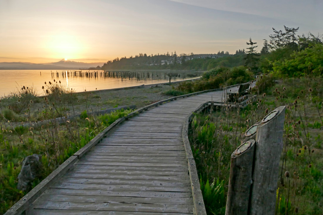
 Along the asphalt of the linear Guemes Channel trail, hikers, joggers, strollers and dog walkers tend to be mission oriented, getting down the trail and then back, determined and purposeful. But meandering the other direction through the Ship Harbor Interpretive Pathway gives a different feel, and a different approach, one of discovery, of exploration, of adventure unplanned. First comes a choice: walk the half mile of beach first, or follow the dirt trail winding through the wetland woods. The beach is a half-moon sweep of pure sand, tree-lined and then beach grasses along the edges. The ferries and lines of cars lie in wait far off in the hazy distance. Here it’s just you, the sand, the lapping of water and the backdrop of offshore islands. I tend to start here first, wandering the seashore until my busy thoughts open to overflowing wonderment and joy. The sand is deep, clean, and soft underfoot. The ambience is a balm to the spirit. Ferries loading to the left, Cypress and Guemes lying offshore, Baker in the distance, nothing but gentle waves lapping at my feet, forests and marsh behind and sky above. Time is forever now. Rows of pilings hint at the stories of yesteryear, at the industries that transformed this harbor into serious business. Today only the herons are industrious, feeding in the shallows of low tide for passing forage fish. At the western end of the beach I head back along the boardwalk, but in no hurry. I linger at each turnout along the way, absorbing the sounds of redwings, the flight of swallows, the hesitant dance of rabbits and their young, the sway of alder and cattail. Here a branch of the boardwalk turns into the wetland, winding through like ribbons of discovery. My progress becomes slower and deliberate, senses awakened to all that is alive. New songs flitter from the leaves above. I stop and look and listen. Waxwings hunt for osoberries, Wilson warblers for insects, a song sparrow for an audience for its melody. Finches and flowers, osprey and open water compete for my attention and delight. I linger and loop; I’m lost in the richness of life along this strand of beach. Others wander past me, most at a quiet pace, attuned to the magic of the moments, the power of a wonderland of life of which we are a visitor, a guest, made richer and healthier by the experience. Some are here to pass the time as they wait for a ferry. Some are here to absorb something of the marshes and beaches. Some stroll the beach, some the boardwalk, but all sense the beauty of this natural world, and become more engaged and alive. Much of this area would now look like home to those who still call this harbor their home, the Samish and their Salish cousins. It wasn’t always like this. A hundred years ago the pilings and shoreline hummed and drummed with the sounds of salmon canneries, filling the wetlands and waterways with buildings, warehouses filling the fill, businesses at work. Today only the pilings remain. The shoreline slowly reclaims its health and beauty, the wildlands behind slowly become wildlife habitat once again. In the early morning dawn all is quiet other than a few birds lending their voices to the background. By midday handfuls of solo walkers or couples stroll by, entranced by the easy pathways through complex environments. By afternoon and evening a few families play on the beach, and a few people waiting for a ferry hike past, but mostly it’s those lost in reverie like me, our feet dancing, our spirits flying, our hearts and minds at peace. Wait only for my boot heels to be wanderin'… Out to the windy beach Far from the twisted reach of crazy sorrow Yes, to dance beneath the diamond sky with one hand waving free Silhouetted by the sea Circled by the circus sands… In the jingle jangle morning I’ll come following you. jack Click here to enjoy the scenes and sounds in a three and a half minute long video https://youtu.be/nmCnjGgq67Y Lyrics above and in video from Mr. Tambourine Man, written and performed by Bob Dylan. The other song in the video is the theme song to The Detectorists, music written and performed by Johnny Flynn. Directions: From Anacortes take 12th Street west, which becomes Oakes Avenue. Turn right at the roundabout onto Ship Harbor Street and then left at the T onto Edwards Way. Follow this down to the water's edge. Ship Harbor Interpretive Path is on your left, the Guemes Channel Trail is on your right.
Access: The Skagit Transit 410 bus services the Washington State Ferry Terminal. You can walk from the terminal down a short grassy hillside onto the beach and then you'll see the west end of the Ship Harbor Trail. You may also ride your bike from Anacortes along the same roadway. The shoulder averages about three to four feet in width on both sides. Accessibility: the trail is hardened gravel along the interpretive pathway, with a short hill at the very beginning that will challenge unassisted wheelchairs. Some of the platforms have a step up. The boardwalk is generally accessible to most all people. Much of the beach is soft sand.
0 Comments
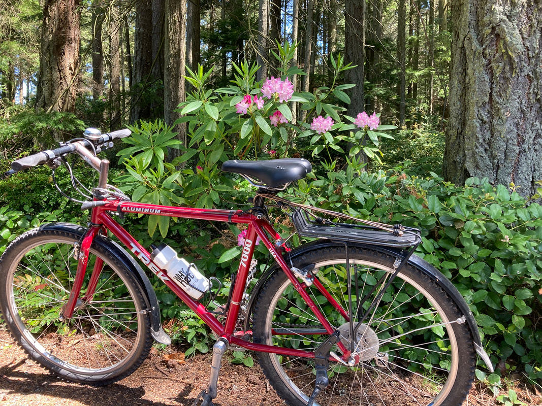 They used to call it Bike to Work Day, or Bike to School Day. Now it’s Bike Everywhere Day and it’s officially on Friday, May 21st! Inspired by Jack’s previous blog I thought about the bike trails on Whidbey. There’s a plan for a Boat to Bridge bike path, but so far only a few miles of that exist. Yet, we have some nice places to ride, around Crockett Lake in Coupeville, or from Langley down to Maxwelton beach, or on Swantown Road out to Joseph Whidbey State Park. But I decided to take an actual bike path that parallels the highway in Coupeville for 3.7 miles and connects with several trailheads and bus stops. I got my bike out of the shed, checked the tires, the brakes and the lights. It had been awhile since we’d spent time together. I started from Rhododendron Park. The Rhody Road through the middle of the park is a paved service road that’s accessible for anyone on wheels and it shows off the native rhododendrons in full bloom. As I took the Rhododendron Trail bike path westward I passed bright orange poppies and lush wild roses. Between Terry Road and Main Street I stopped to watch a farmer cutting hay with a swarm of eagles following to pick up the field mice. Here's a glimpse. At Main Street I crossed at the light where the bike path is called the Kettles Trail. I saw the Southbound bus turn off the highway and onto Broadway toward Coupeville. I love the transit and trail connections. See the North Whidbey connections or the South Whidbey connections. There were great views across Ebey’s Prairie to the Olympics beyond. The dark fields were framed by yellow flowers along the trail. I climbed up to Sherman Road and continued by colorful bird houses. There’s a big dip where I sped down a steep hill and on the rise I stopped at the Spur Trail that leads to the Pratt Loop Trail that connects with the Ridge Trail that leads to the Ebey’s Bluff Trail. About 30 feet from the bike path is a kiosk with a map that shows these connections. There’s a rack where you can lock up your bike as wheels are not allowed on those trails. So I continued on the bike path passing more beautiful rhododendrons, lupine and Scotch’s broom. At the end of the paved bike path, is the beginning of the dirt Kettles Trails which are popular with mountain bikes. I stopped to look at the kiosk with a map of this extensive network of trails that connect with Fort Ebey State Park. A new trailhead at Libbey Road makes it easy to bring a bike or go for a hike by bus. Buses can carry 2-3 bikes. On my ride back toward town I noticed a big tractor making giant marshmallows out of hay. I crossed the highway at Sherman Road to get a closer look. Then I rode down the side road to Broadway. Just across the street is the Kreuger Trail so I took that route through the woods coming out on North Main Street. Crossing Highway 20 on the pedestrian overpass I got a good view of the bike path. I returned to Rhododendron Park happy to be reunited with my bike. Yesterday I was in my garden when I heard someone call hello. Janet rode up on her bike followed by Laura on her electric bike pulling two toddlers in a bike trailer. They’re bike and bus aficionados determined to keep their carbon footprint small. They don’t own a car but go everywhere by bike, so for them every day is Bike Everywhere Day! Directions: This 3.7 mile bike path runs alongside Highway 20 in Coupeville. You can start at Rhododendron Park which is 1.7 miles east of the pedestrian overpass at Main Street. Or you can start at the Elementary School on South Main Street and go in either direction.
Island Transit Route 1 or Route 6 stops at Libby Road, Sherman Road, Broadway or Coupeville Elementary School on South Main Street, and the Route 1 bus will also stop at Jacobs Road, near Rhododendron Park. Wheelchairs or hand cycles may use the Kettles Trail west of Main Street as the bollards are set wide enough apart to allow access. The bollards on the Rhododendron Trail may be too close together for some wheelchair access.  Two minute video summary: https://youtu.be/2fNquOaH03s May is National Bike Month, celebrated in communities from coast to coast. Established in 1956, National Bike Month is a chance to showcase the many benefits of bicycling — and encourage more folks to giving biking a try. Bike to Work Week 2021 will take place May 17-23, 2021 and Bike to Work Day is on Friday, May 21 – next Friday. There are many ways to celebrate Bike Month. Whether you’re riding for fun, fitness or with family, or taking essential trips to work or shop, you are part of the movement for safer streets, connected communities, a healthier planet, and happier people. “Think of bicycles as ridable art that can just about save the world.” — Grant Petersen, bicycle designer. With 68 hikes in the latest edition of Hiking Close to Home, there are many, many places to lose yourself and find yourself in our neighborhoods and nearby parklands. Some of these trails make for wonderful biking opportunities too, to tax and relax our minds and bodies as the trail gives us challenges to meet and play with. Some are just perfect for a gentle pedal or at a fast race on a bike, or a delightful walk, or a roller skate tour or a wheelchair ramble or for pushing a stroller or taking a jog or riding a hoverboard or anything else we can think of that moves our bodies with our own energy. And one trail in particular has all of these opportunities, while connecting a downtown area with two ferry routes, with the transit hub for Fidalgo Island, with the Samish tribal center and dozens of local businesses, all while safe from traffic, hugging the water and even crossing over the bay on a trestle. I am of course referring to the Tommy Thompson Trail in and around Anacortes. It starts (or ends) near the downtown Safeway, and flows south past the boat yards, separated from highway traffic, and out onto the shaded stretch that follows the west shore of Fidalgo Bay, past the Samish conference center and campground, and then east across the trestle to March’s Point and the Skagit/Island Transit bus hub. A few weeks ago I had the pleasure of riding from La Conner to the TTT as I call it and back to my home in Anacortes. Other than some highway riding just outside La Conner, I was on a separated path or on quiet roads which eventually led me to the final four miles of the TTT, which took me home. And Maribeth and I have ridden our bikes from downtown Anacortes west to the Guemes Ferry, and also out to the San Juan ferry. Unfortunately, the route to the San Juan ferry is Highway 20, with a shoulder lane for bicycles but still close to the very busy roadway. The Guemes Channel Trail can help solve this dilemma in the near future. We need to finish the connection between the ferry and Anacortes at the boat yards, to allow bicycles to ride safely off the road, along the waterfront like the TTT, and get to and from downtown Anacortes. Eventually the trail could stretch from the east end of Fidalgo Island all the way to its western tip at Washington Park. The dream is there, the plans are in place. We can make it happen. “Bicycles are the indicator species of a community, like shellfish in a bay.” — P. Martin Scott This week I had a grandpa’s joy of helping a granddaughter learn to ride a bike. Words cannot share the release that she felt of achieving the accomplishment and now having the freedom of riding a bike on her own. There’s no stopping her now. We will be looking for safe trails for her. The Tommy Thompson will be one of the first we will try. - jack (The photos are in the video.) 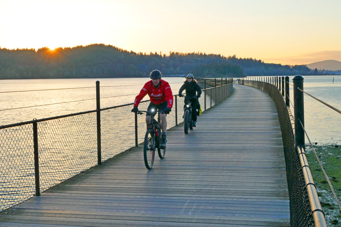 Directions: In Anacortes, you can park at the Cap Sante Marina or at Anthony's Restaurant across from Safeway, or where 34th Street crosses the trail near the water. There is a small parking lot at Fidalgo Bay RV for trail users. You can also park at the March's Point Park and Ride and then hike or bike the 3/4 mile to the beginning of the trestle.
Transit Access: from the March's Point Park and Ride, as mentioned above, or Skagit Transit bus 410 into Anacortes, stopping at the 10th and Q bus stop. Accessibility: the trail is paved the entire four miles except for the trestle, which is partly wooden deck boards and partly composite deck boards. It is level or nearly level the entire way, about ten feet wide, with scenery to enjoy for nearly every minute on the trail. There are a handful of street crossings at the north end of the trail; only one once you go south from 34th Street, at the RV resort. 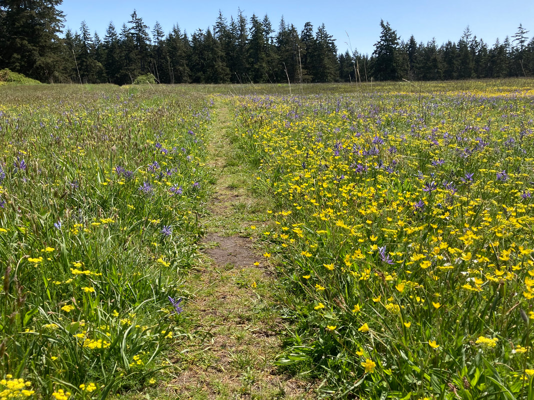 Imagine arriving by canoe 200 years ago and climbing from the beach up the bank to see a wide open prairie awash with flowers, yellow, blue, white, pink and purple framed by old growth fir trees where elk and wolves roamed free. Scan the prairie here. A bit of a stretch for the imagination perhaps, but if you’d like just a taste of that experience, take a walk at Pacific Rim Institute where prairie restoration goes on today. Fortunately for me, I get to take walks here during my lunch break almost daily. I’ve walked here in the snow and rain, and on many windy days. But this is a very special time of year at PRI when the native wildflowers are in full bloom. I was there this week and caught Mosa weeding the mound where they’ve grown many prairie flowers to display. She pointed out a dozen varieties, most of them in bloom and others we look forward to seeing flower later in the summer. If you call ahead you can take a tour with Mosa in person with appropriate distancing. Or get a video tour here. I got a quick tour of the mound and then left Mosa to continue weeding while I walked out to see the fields of flowers beyond the row of sheds. My walk between the sheds always reminds me of the old out buildings on my grandparent’s farm. This used to be the “old pheasant farm” and the sheds were coops for the fancy feathered birds. These days the pheasants are gone but there are always different things piled up between or inside the sheds. Walking straight out from the row of sheds I pass a primitive chair and keep going across the field following a faint track. At the far side of the field I come to a fence and have to decide, right or left. I wander to the right into a field of yellow and white flowers. Then swing back to the left along the old farm road where a sign reads, Walk to Prairie. At the end of the fence is another sign saying Prairie Remnant. I pass around it and follow the trail by blue camas, pink sea thrift and an assortment of yellow flowers. I come upon a row of white chickweed like stars in the Milky Way on a green night sky. And then the endangered golden paintbrush. I try to stay on the trail so as not to crush any new growth. A little further on are some very large old growth trees creating shade on a warm sunny landscape. Turning back now, with the buildings just out of sight, I get the feeling of walking in a prairie as it might have been a hundred years ago. The crew at Pacific Rim Institute have been propagating these plants and restoring this native prairie. They’ve built raised beds and collected seeds, even used controlled burns to stimulate growth. Parts of the prairie are fenced to restrict deer. But birds fly freely between the many bird houses, trees and brambles. I see swallows and sparrows, hawks and eagles, crows and ravens. Occasionally, I’ve heard there are mountain bluebird sightings here. If I have time I turn north toward the old barn at the edge of the woods passing native Garry oaks. Turning at the barn I circle back to the buildings passing the fenced raised beds where volunteers are watering. Volunteers are active here and they welcome more. Call 360-678-5586 to arrange a visit. And be sure to wander out to the fields of flowers while they’re in full bloom. Directions: Take Highway 20 from Coupeville south for 3 miles and turn left on Morris Road. Turn left again on Parker Road and in a half mile Pacific Rim Institute will be on the right. Park near the house and find the wildflower display mound on the left just before entering the row of sheds.
Take the Route 1 bus Monday-Friday to the Morris Road stop and cross the field to the east to Parker Road. Walk a half mile north to Pacific Rim Institute. The bus does not go here on the weekend. Bring a Bike -2-3 bikes fit on a bus bike rack. Please don't bike through the fields. Mobility: The old farm roads are mostly level and easy to walk, but a bit rough for a wheelchair. |
Authors
Maribeth Crandell has been a hiking guide in the Pacific NW for over 20 years. She's lived on Whidbey and Fidalgo Island for decades. As a frequent bus rider she easily makes connections between trails and transit. Archives by date
July 2024
Categories
All
|
 RSS Feed
