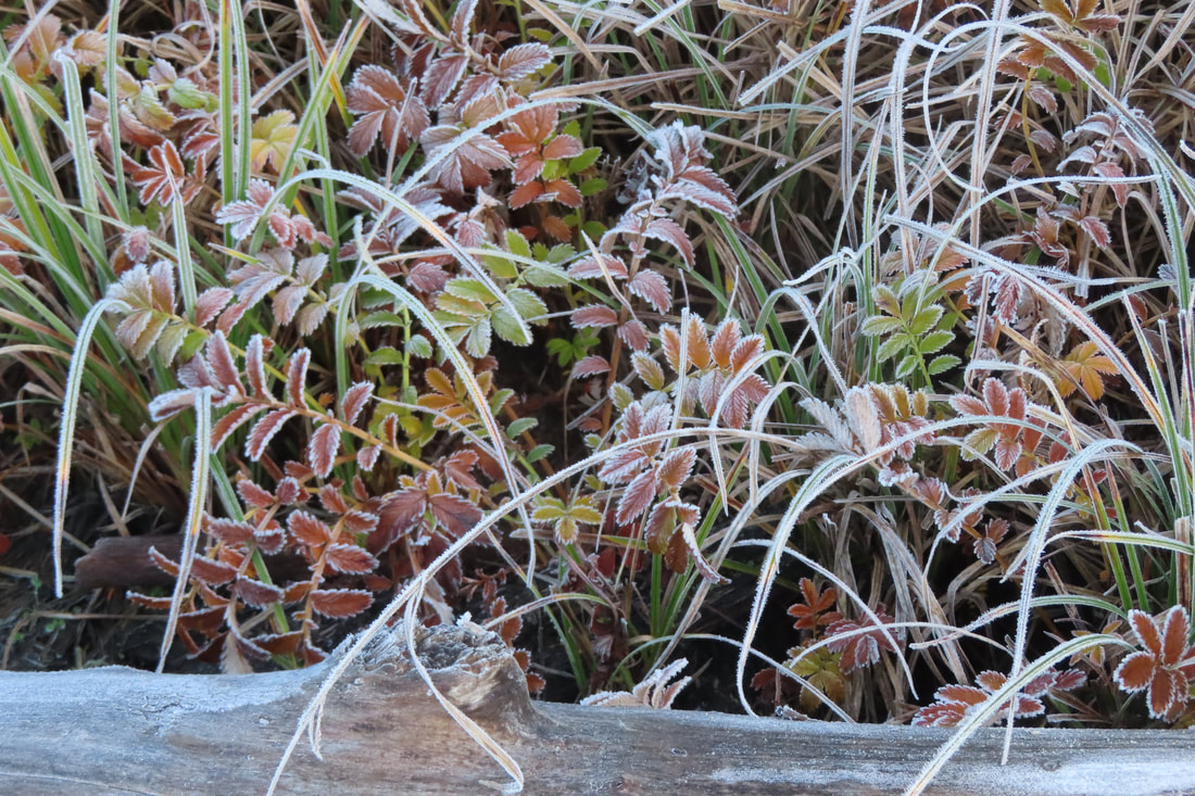
 Dark and bright, day and night, cold and warm, calm and storm. We live in a world of contrasts that make our lives richer. This week I became acutely aware as I went camping in my unheated van as temperatures dropped below freezing. I was warm in my sleeping bag, but outside, it was frigid. The days were filled with bright sunshine, followed by the cold, dark, long winter nights. A full moon rose offering its brilliance, but sadly, no warmth. The morning sun slept in (as many of us did the day after Thanksgiving) and then struggled to burn through the frozen fog. So I came home to my warm hearth and electric lights, grateful to be indoors during the longest, coldest nights of the year. Still, the days this week have been bright and inviting. I bundled up and went to Joseph Whidbey State Park with Lee. She’ll head up our Christmas Bird Count team in a few weeks and we wanted to get an idea of what to expect. Joseph Whidbey is a park of contrasts. The beach offers trails just high enough to avoid even King Tides. Trails climb the bluff into the forest and on to open meadows. It’s a diverse habitat and attracts a variety of birds. By the water we saw gulls, loons, grebes and mergansers dipping into their underwater world. Out on the horizon, Smith Island lies low, directly in the path of Pacific storms that blow in on the Strait of Juan de Fuca. Its’ home to rhinoceros auklets, tufted puffins, pigeon guillemots, cormorants and enough gulls to inspire an Alfred Hitchcock movie. As I watch a research boat glide by, I remember that Smith and Minor Islands are in an Aquatic Reserve along with over 36,000 acres of water around it. The reserve protects one of the largest kelp beds in the region. Like an old growth forest, these kelp beds protect aquatic plants and animals including crabs and fish that many people rely on for food or their livelihood. We walked along the sandy shore and then stepped over driftwood to a grassy path. It was mid-day, almost warm, but in the shade, icy whiskers grew on frozen logs and plants were etched in frost. Overhead, tiny birds circled and dove, together as one, chattering and chirping. “Pine siskins,” Lee said. “How many?” “50? 60?” Called by more birds we went from sun to shade, beach to forest. We climbed the stairs to a path between towering firs and leaning alders. Listen. Chickadees, juncos, a nuthatch and wren. A dark shape glided in and all went quiet. Raven. It soon paddled off through the trees and the chatter resumed. Passing by a radiant golden willow, we entered the fields hemmed in by a blush of wild rose. Kinglets and sparrows dodged in and out of the prickly shrubs. Towhees teased us from low branches. Eagles called from the shoreline. A Harrier glided low over the field, hunting for a meal. A boardwalk, framed walkways with fresh gravel and sturdy benches showed the care of the maintenance crew and volunteers. On our return, we met one blowing leaves off the trail. He turned off the blower to chat. We thanked him and walked on to the picnic area atop a hill with views of the water. From field to forest, shadow to light. It wouldn’t be long before the sun would set over Smith and Minor Islands. By then, I’d be home, with electric lights, and supper on the stove. We have so much to be thankful for, wonderful places like this to explore, birds, kelp beds, forests, fields, beaches, bluffs, and a warm place to come home to through the long, winter night. Maribeth For more on Smith and Minor Island Aquatic Reserve click here. Directions: From Highway 20 just north of Oak Harbor, take Ault Field Road (by the jets), go straight at the round-about, pass the golf course and right at the “T” on Crosby Road. At a turn in the road you may see cars parked by a trailhead at the north end of the park. Or continue to the main entrance where a State Park Discover Pass is required for parking. Or park at the beach where no pass is required. Or take Crosby or Swantown Road from Oak Harbor west to the park entrance. Or from Coupeville, take Highway 20 north 4 miles, turn left onto Libbey Road and then right on West Beach Road to the park.
By Bike or Bus: There’s no bus service to the park but buses can carry 2 bikes. The free, weekday Route 9 bus stops at Monticello and Swantown Road (near the Oak Harbor Christian Reformed Church). From there it’s just 1.6 miles to the park entrance on a flat, low traffic road. Or bike from Hwy 20 (near Walmart) on Swantown Road for a 3 mile ride. Please wear bright colors and use lights when riding on the road. For the bus schedule click here. https://www.islandtransit.org/Route9WWeekday Mobility: The trails near the beach and through the forest are almost flat but there’s a steep hill between them. You can park at the beach or by the main entrance to be on either level. The main trails are well maintained but some may be muddy after a rain.
0 Comments
 This land is glacial land Along Fidalgo Bay rises a ridge of dark cedars and firs, a silent witness to the past. A few thousand years ago, a mile-thick sheet of ice retreated from this land, scraping and carving the landforms we see today. Cold-adapted trees seeded back in, leaving forests thicker than dog’s hair on the backs of our hills, and gravelly lakes in the dales. This land is wild land Grebes and great blues, buffles and loons, salmon and seaweeds, seals and seagulls and many others returned too, their new home a perfect web of shared habitats. Abundance filled the shores of the Salish Sea. This land is Samish land As the ice melted, the first peoples also found their way here, and have called this their home for thousands of years. They developed a culture interwoven with the tides and seasons of life along the Salish Sea. Their descendants and traditions live on, celebrated at the tribal center along Weaverling Spit. This land is immigrant land A couple hundred years ago, the tribes welcomed some sailing ships passing through, and opened their arms and lands to these unusual people with white skin, funny clothes, and strange ways. These new people removed the forests to build a town, changed the land to grow vast fields of new foods and raised animals large and small. This land is industrial land The new people kept making changes. They filled the beaches for plywood mills and fish canneries. They filled the marshes for boat harbors; they dammed the lakes for water to be piped down to the town. They built railroads to carry these goods far away and bring in other goods. They shipped in oil from around the world and cooked it right here, for trains to take it to others for burning as fuels. The land hummed with energy, with industry, with growth. This land is shared land But a new age has dawned. The factories have been removed, some of the beaches restored. The remaining forests still stand, protected for the future. Growth is measured and managed. And where the railroad once ran, a pathway now stretches from town to March’s Point, along and over the water of the bay. I kept singing “This Land” as Kath and I hiked west from the refineries on the Tommy Thompson trail. The late-fall sun brightened people’s spirits. The air was calm, the waters flat. The “Tommy” bustled with walkers, strollers, bikers, and joggers, in bunches, in pairs, or alone. We watched from the trail as shorebirds floated and dove in the waters of Fidalgo, gathering a Thanksgiving meal a stone’s throw from our feet. Herons squawked overhead, loons sparkled majestically in the backlit waters. Mallards and teals scooted among the brush of a wetland. We approached the campground and tribal center. Leaving behind the scores of people still streaming along the trail, we walked out to the beach on Fidalgo Bay, more natural and appealing than before thanks to the restoration work being done by the tribe. The sun was getting low now, so we headed back. People who had passed us as we headed west were now returning to town. Baker floated above the steaming stacks of the refinery. Brilliant madrone berries stood out from their dark green leaves, turning the shores into a holiday display. Cottonwoods on March’s Point blazed golden in the sunset. The water lay like molten silver dimpled with ducks on both sides of the trestle. The sky is wide open here, tempting our minds and hearts to soar. My heart overflowed with thankfulness that we have this trail that bridges people and nature, the past and the present, the local and the global. This trail is a shared heritage, keeping us active, and bringing us back to our roots, the stories of this home that we share. This land belongs to us all. jack And a heartfelt thank you to our readers at this season of Thanksgiving. Maribeth and I have enjoyed bringing you four years of trail stories now, sharing our love of these lands and trails. And a respectful and grateful thank you to those who help protect these lands, and those who build and maintain these trails that we enjoy. Happy Thanksgiving! We are blessed beyond measure. Enjoy this video of our walk, condensed down to just two minutes. https://youtu.be/BLK8Knd44Bk Directions: In Anacortes, R Avenue is closed right now between 22nd and 34th, so take one of those two streets to go east from R Avenue to pick up the trail. That's one reason we started at the east end of the trail, on the west side of March's Point, about a 3/4 of a mile north of Highway 20, where there is very limited parking.
By Bus: Island and Skagit Transit go to March's Point Park and Ride; then walk or bike the 3/4 mile to the east end of the trestle. Or take the Skagit Transit 410 bus into Anacortes, get off at 10th and Q, and walk east to reach the path along the waterfront. By Bike: see the directions above. The trail is ideal for biking too. Mobility: the entire trail is paved (except for the planking on the trestle), wide, relatively flat, free of cars except where it crosses roadways, and full of adventure waiting for you.  It all started with an off-duty sous chef. It had been a slow day at work for him, so he decided to hike from Little Cranberry Lake to Whistle Lake on his extended break. But we found him to be in no hurry. He was resting on a bench at Heart Lake, soaking up the sun, not yet even halfway to his hoped-for destination. When he mentioned his goal, Kath and I looked at each other and said, “What a great idea.” Not long after, on another sunny but cool day, we parked one car at Little Cranberry and drove another to the Whistle Lake trailhead, our packs laden with water and snacks, and our backs with several layers of clothing. We had the goal of visiting three lakes and two named ponds by hiking about six miles through the beauty of autumn in the ACFL. Murphy led the way, pulling at his leash for us to go faster. He would turn around and look at us as if to say, “Why are you so slow? Let’s go!” By the time we got halfway around Whistle, we had put our outer clothing layers in our packs. The sun blazed at its low angle, warming our outsides, while the up and down of the trail warmed our insides. Whistle glistened, deep blue, sparklingly fresh, and inspiring in its beauty. At a canopied overlook, Kath just stood for a while, quiet and thoughtful. Too soon I interrupted and asked if she was okay. “I’m just soaking up the peacefulness of this place,” she replied. Her centered approach slowed my pace and heightened my awareness of all that was around us. The trail began climbing away from the lake through the hills. More layers came off. “At this rate I might be naked before we get to Heart Lake,” I joked, but then the sun went behind a cloud, removing that danger. The woods were quiet. Few animals stirred on this mid-autumn Sunday afternoon. Few people did, either. The trails were surprisingly empty. Maybe the Seahawks were playing. As we dropped down towards Heart Lake, a handful of bikers were peddling up the steep trail. A gutsy workout. The trail empties out onto Heart Lake Road near the parking lot. We crossed, took a potty break, shared some water, and enjoyed a small snack. Murphy did all this too, except for the shared water part. He has his own. We followed the eastern shore of Heart Lake, crossed the outlet, then continued north to find the trails that lead to Little Cranberry. Some housing developments come close to the trail in places here, or is it that the trail comes close to several houses? It’s a narrow corridor leading to Havekost Road, then a quick scamper across the road to another trail corridor between a gravel pit and more houses. Sunshine lingered and our destination beckoned, as did the promise of pizza for dinner, leading us onward. After climbing a couple short ridges, we were at Mitten Pond. The sun was lower, shadows were lengthening. We skirted the quiet shallows of the pond, walked north to the west shore of Big Beaver, then clambered up and down a ridge to the bridge over Little Cranberry’s inlet. Murphy was now lagging, looking up to us as if to say, “What’s the hurry? Let’s rest.” Soon we would. The evening sunlight burnished Little Cranberry’s eastern shoreline to gold. In the deepening shadows on the western side, we followed the roller-coaster trail around trees, up and down rocks and over slippery slopes. We dragged into the parking lot, our feet tired, our hunger piqued, and our joy full. Then again, "The destination is not the point," the sous chef had said. Hiking, as is life, are all about the journey. jack “The only thing that is ultimately real about your journey is the step that you are taking at this moment. That's all there ever is.” – Alan Watts
Directions: You can start and finish anywhere you wish in the ACFL. We chose to start at the Whistle Lake parking area. To get here, go south from the roundabout on Commercial Avenue in Anacortes. Take a left at the 't' onto Fidalgo Avenue, left again on Hillcrest, and then right onto Whistle Lake Road. Follow the signs carefully at the end of the road, as the route turns left down a hill, twists right, then right again and up a dirt road to the parking area. Or make a different plan. The journey is the thing. By bus: The nearest bus service is to Commercial Avenue in Anacortes, about three miles from Whistle Lake. By bike: It's a good ride from Anacortes to Whistle, as described above, with lots of hills, twists and turns on mostly quiet roads once you go south from the roundabout. Mobility: There are some wide dirt roads in the ACFL with some elevation changes but mostly firmly packed dirt. Some are not so easy. 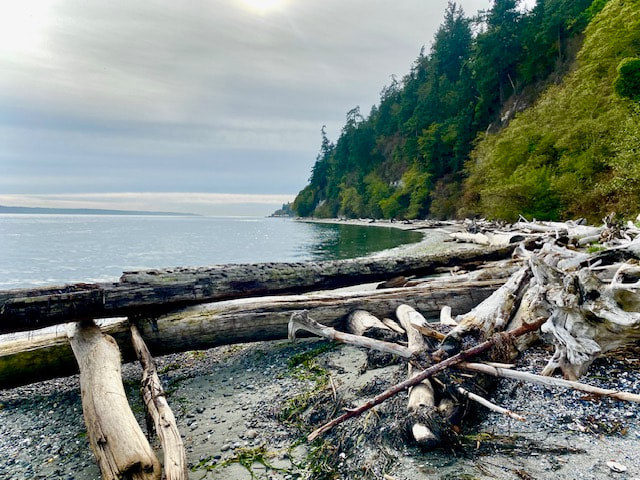 I stepped into the Madrona Supply store in Clinton, delivered my box of books to the owner, and heard the buzz. A whale? A big splash? A breach? But where was it? What kind? Was it alone? Which way did it go? I felt like a detective questioning the eye witnesses just after a crime. One pointed toward Everett. Another said it went south. No one seemed to know much, but they all agreed it was a whale and it was here just a moment ago. Looking out from the ferry dock, even with binoculars, I saw no sign. If it was breaching, and not an Orca, it could be a Humpback, something I’d never seen in Puget Sound before. I had other errands to run, but they could wait. I drove to the Possession Sound Preserve. If it was going south, perhaps I’d see it there. Hurrying down the trail I passed a volunteer on her knees weeding under the split rail fence. Her project which she took on single-handed, had progressed steadily, leaving baby ferns and beauty bark in her wake. I offered her a quick compliment and continued on hopeful of catching a glimpse of the mysterious marine mammal. It was the best day to be outside in a week of wind and rain. Perhaps the best hour. The skies were clearing and the water calm. I took the trail down to the beach and scanned with binoculars, north to south. Mount Baker, the Everett skyline, the ferry docked in Mukilteo, the lighthouse, a small boat with a rower and a fisherman, some gulls calling and cormorants perched on near shore pilings drying their wings. The fishermen didn’t seem alarmed by anything larger than the bait they repeatedly threw out and reeled in. It appeared that no whales had come this way, at least not recently. I took a deep breath and relaxed. I heard the tiny voices of small birds in a bluff full of blackberry brambles behind me. A frenzied flutter of finches shifted from one shrub to the next like hands on a keyboard, moving up an octave to play the same tune. I turned back toward the water. The ferry left the Mukilteo dock and plowed toward Clinton. With snowy Mount Baker behind, it seemed very near. Climbing over the driftwood barrier I stepped to the beach beyond. The tide was going out leaving a sandy walkway between the wood and the water. A blue and white backwash of broken mussel shells caught my eye. The contrasting colors and textures of twisted grey driftwood and shiny blue shells on a soft shore of sand made me stop and appreciate the small things. Wandering down the beach I came upon a flock of mergansers swimming out from shore. I turned so as not to disturb them and headed back the way I’d come. Bunches of pale purple wild flowers still bloomed near the bluff. Crossing the wide lawn by the beach I marveled at the brilliant poplar trees and how they look like flame throwers as their leaves turn gold in the fall. Climbing the trail to where a bit of the bluff had broken off, I was reminded that the only thing constant is change. At the top of the hill, the volunteer was still working away. I walked on and marveled at the rustic beauty of a split rail fence. A flicker landed on the top rail with its intricate pattern of speckled feathers, and had a long look at me. It would have been exciting to see a Humpback Whale breaching in Possession Sound, but this shoreline held a subtler magic all its own, and it is there whenever you wish to find it. Maribeth For more info on the Possession Sound Preserve and the Whidbey Camano Land Trust, click here. Directions: From Highway 525 in Clinton, turn south on Humphrey Road at Simmons Garage. Drive two miles, slow down and look for the entrance on the left just after Bay Ridge Road.
Bus and Bike: The closest bus stop is at the Clinton Park and Ride 2 miles away. Routes 1 and 60 stop in Clinton. Humphrey Road is a moderately traveled road with not much shoulder. Two bikes fit on a bus bike rack. If you ride a bike on the road, please wear bright clothes and use front and back lights. Mobility: The upper trail is a wide, gravel path. The trail down to the beach is steep and may be slippery when wet. There is a short narrow stretch where the bluff has fallen away on one side. Just above the beach is a wide, flat lawn, about the size of a football field. Driftwood forms a barrier between the lawn and beach. High tides may prevent access to the beach itself. |
Authors
Maribeth Crandell has been a hiking guide in the Pacific NW for over 20 years. She's lived on Whidbey and Fidalgo Island for decades. As a frequent bus rider she easily makes connections between trails and transit. Archives by date
July 2024
Categories
All
|
 RSS Feed
