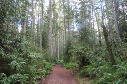
 The sun was out, I was restless, so I went to explore the Trustland Trails near Bayview. I’d heard there were some new trails and I wanted to try them out. Studying the map at the trailhead kiosk, there were many options to choose from! Lots of loops within loops. I decided to make the biggest loop and started in a counterclockwise direction. It was smooth sailing along the first stretch as I walked west on Mossy Way. I saw the church through the trees as I turned south on Swordfern Lane. I was walking in an emerald forest. There was so much lush, green vegetation. Salal, sword fern and evergreen huckleberry made a hedge on each side. Tall trees made a green canopy above. This is so different from the deciduous forests where I grew up. There a carpet of brown leaves lay thick on the ground and bare branches rattled in winter winds above. But here, in this Evergreen State, we have lush life all around us even in the depth of winter. The trail was smooth and wide with little paths connecting local neighborhoods. I began to meet people walking their dogs. First, a big, friendly, yellow lab with its equally friendly people. Later, a nice older couple with an older speckled dog, pulling them along. And finally, an old friend with her two small pooches who perched on their favorite stump for a treat. I looped around Alder Alley and came back north on the newly constructed trails from Cedar Hollow to the Overlook Trail where there’s a steep ravine below. On the Ravine Loop I started noticing the curious shapes of trees and stumps. One had a spray of salal erupting from the top and hanging almost to the ground. Another large stump had the tell-tale springboard notch, evidence of the use of a two-man saw. The notch looks like the stump has an open mouth and will tell you about it if you stay awhile. As I came back to the Cedar Hollow trail, there was a tree with the candelabra of limbs that started growing straight up when the top was broken. And another tree with a loop in the trunk. I stopped in my tracks wondering how that could have happened. I continued north on the Raven Ridge trail. This is the hilly end of the park. Climbing helped me stay warm on this winter day. After an hour I reached the ADA loop near the entrance. The Serenity Loop is almost level with a surface of packed gravel, easily wide enough for two wheelchairs to pass. It’s a calm, quiet and lovely forest. The trail is smooth, wide, and inviting. As I was coming out at the parking lot, I met Jan who was just getting out of her car. She was putting her cane away and pulling her walker out. We talked for a few minutes. She loved walking the South Whidbey trails and we laughed about getting lost on a few. She posed for a picture as she set out on her walk around the loop trail. Another friend had told me how she used to bring her father there in his wheelchair. She said it gave him a lot of peace and pleasure. It’s such a blessing to have all these trails here, whether you do the biggest hilliest loop, the littlest smoothest loop, or something in between. They all bring joy and peace to an open heart. Maribeth Take a picture of the map at the trailhead kiosk with your phone or download this one before you go. South Whidbey Parks and Recreation welcome volunteer trail maintainers. Call 360-221-5484 for details. Directions: The Trustland Trails are on South Whidbey Island just off Highway 525, 1.5 miles south of the stoplight at Bayview, 9 miles north of the Clinton ferry. Turn south on Craw Road then take an immediate right into the parking lot. The park has a picnic shelter but no restroom. Gates close at dusk.
Bus and Bike: Take the fare-free Island Transit Route 1 or Route 60 bus Southbound from Bayview. Ask the driver to let you off at Craw Road. Walk 100 yards to the park on the right. There is no place for a bus to pull over off the highway going north, so if you need to go north, catch the Southbound bus, and make a connection to a Northbound bus. The friendly bus driver will be happy to help or call 360-678-7771. Or get a schedule here. Mobility: The ADA loop is suitable for those with mobility challenges. It’s about a ½ mile long and almost level with a smooth, hard packed surface. The other trails vary with a few hills but are well maintained and mostly wide and smooth.
0 Comments
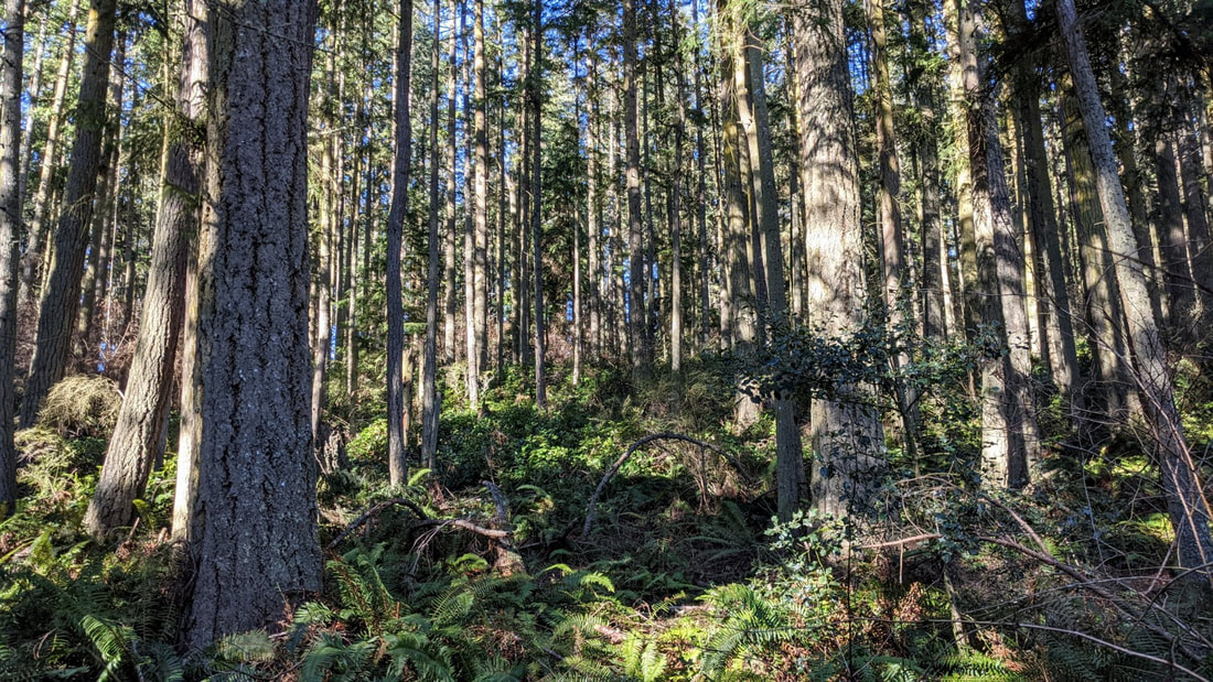 There are many trails in our book that offer magnificent views from hilltops or bluffs. There are many beaches we can walk alongside our Salish Sea. There are trails around lakes and through meadows galore. But sometimes I like to withdraw into nothing but woods, and follow along trails that lead nowhere but into the trees, through the trees, and eventually back to where I started, though I’ve been changed. Such is the case at Hoypus Hill. There is no destination but the forest. The trails meander left and right, up and down, across and through the many shades of environments here. A Rhody forest on the west end is thinking about stirring for spring. Ferns in Fern Alley look tired from the winter weather, but they are emerging anew once again. Alder buds are swelling; osoberry and salmonberry flowers are showing this year’s colors. Spring is gathering its breath, ready to come forth with a shout. Our route was never a decision, just a result of feeling like taking a left here, a right there, a left at the next intersection, and see where we end up. We ended up in the middle of the woods, in the middle of a reverie of peace, in a state of relaxation, refocused by the experience of our hike here. And we grew an attitude of gratitude for those who protected this forest, who kept it from the saw and kept forever our reverence of the forest life that abounds within. Hoypus Hill was logged a couple of times in the past century, as recently as the 1980s. Then DNR transferred it to State Parks for ‘use’ as a park, to become a future old growth forest in a few generations of people, or in just one generation of trees. Sure, it could have been developed into tracts of housing, or logged yet again for the lumber to build some of those houses, or turned into paper, or a church building and parking lot. But here it is, ‘just’ a forest, deep woods, quiet and serene, living and deep and holy. A friend of ours recently posted a picture taken from her saddle as she rode her horse Gracie toward these trails, the woods and ferns filling the scene around her. Her only comment was “Take me to church, Gracie.” A mile away rises the busyness of the park, the hubbub of cars and power boats and pedestrians crossing above or beneath the bridge. Here at Hoypus all we could hear was the soft breath of breezes in the branches, the slow pace of our footsteps along the soft trail, and our occasional whispered words expressing the tranquility of being here. Mostly we walked in silence and sacredness, becoming aware of the details of emerging plants creating green carpets on hillsides; of ankle-high nettles ripe for a salad; of fallen trees becoming rising seedlings; of bare branches swaying above us ever so gently, like hands raised in thanksgiving. Karle Wilson Baker once said “Today I have grown taller from walking with the trees.” Thoreau grew even more: “I took a walk in the woods and came out taller than the trees.” I don’t know if I felt taller or smaller, seeing the size and age of some of these trees, knowing that their world is so much more rooted and grounded in the earth and sky than the one I would soon return to. I do know that I am humbled by the hour or two I spent within the forests of Hoypus Hill. When you don’t believe in yourself We will When you’re worried We aren’t When you’re afraid We are not When you feel alone We are with you We are the trees The mountains The rocks The grass The earth beneath your feet The everythingness of everything That you are a part of too. -- Anastasia Allison jack Directions: From the Deception Pass Bridge, drive south 1.2 miles to Ducken Road. Head east on Ducken to the road end. The trail begins from this parking lot.
By Bus and Bike: Island Transit Route 411W goes from Oak Harbor along Highway 20 toward Anacortes. It stops at the store just north of Cornet Bay Road when northbound, and just south of Cornet Bay Road when southbound. By request it can also take Troxell Road to Ducken Road, leaving you just a half mile from the road end on Ducken. Bicycles have a challenging time on Highway 20, but if you take the back roads from Oak Harbor you will find more rural and quieter roadways. Mobility: Stay on the main logging road and the trail is wide and mostly well compacted dirt, with a few somewhat steep slopes. The single track trails are a variety of tread and terrain. The trails are somewhat muddy in places right now, but well maintained mostly. 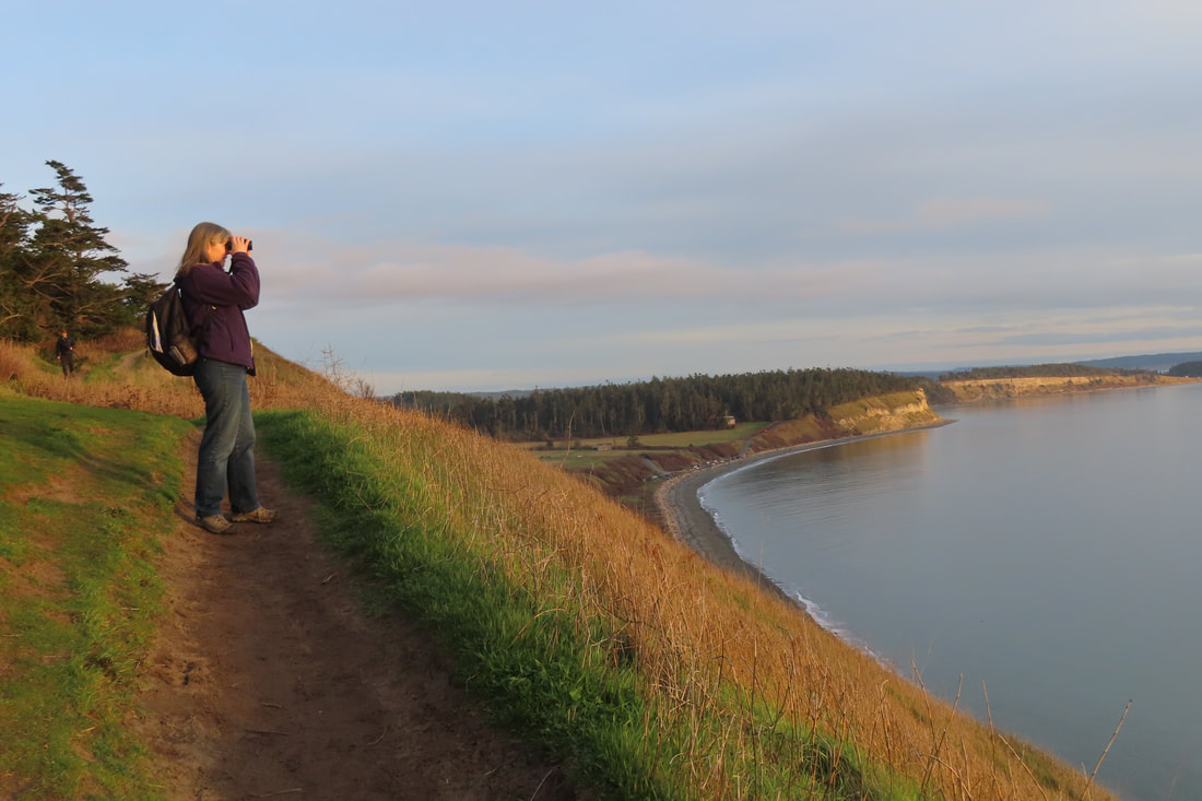 It was a rare sighting on Ebey’s Bluff, a small mammal carrying a small mammal with a cinnamon and white striped tail. A ringtail cat perhaps? But no, I was corrected. It was the endangered red panda, native to the Himalayans, brought to these regions by migrating populations of small homo sapiens. The adorable stuffed animal wasn’t quite as cute as the little hiker carrying it in her arms as she bravely led her parents high up along the bluff trail. But then red pandas are known to inhabit steep slopes, so it was only right that it should take the lead. This stunning trail attracts people from near and far. We met old friends from Bellingham and made new friends from the island. Some walked dogs, but most walked with friends, young, old, black, white, brown. They strolled the beach, they climbed the bluff, they sat in the grass to take in the view. They brought cameras, binoculars, and of course, phones. My hiking partner politely asked one group of young ladies to turn off the music blaring from theirs. They kindly obliged. It was a good day for a walk. After a week of rain, the clouds reluctantly parted, giving way to a pleasant afternoon. We drove down scenic Hill Road on our approach with it’s iconic view of the bluff. Seeing all the cars along the beach and the crowded State Park parking lot we drove up and across the prairie to climb the hill on Cemetery Road and parked by the Ebey’s Landing National Historical Reserve office. From there we walked by stubby fields and the historic Jacob and Sarah Ebey cabin. Following the fence line on the Ridge Trail we arrived at the bluff. The initial 300 foot drop and the expansive view over the water is breathtaking. It brought back so many memories, the times I’d brought my family here when they were visiting from out of state, the group of friends who once walked with me on Christmas Day as the cold wind cut through us like a knife, the farewell party with old hiking partners before I left to hike the Appalachian Trail. This trail was on the cover of Sunset Magazine 20 some years ago listed as one of the Northwest’s “best kept secrets”. It’s no secret anymore. It may be the most popular trail on the Island and well known throughout the region. When people ask me, “What’s your favorite trail?” this one comes quickly to mind. Though I try to steer people to lesser-known trails to spare this one from overuse, Ebey’s Bluff is special. It’s got enough of a climb to get my heart pumping and the views are spectacular all along the 5.6 mile loop. It faces south so even in winter, if there’s any sun at all, you’re in it. (Of course, you also experience the full force of foul weather on wet and windy days.) You can see Mount Baker across the prairie to the northeast, Mount Rainier over Puget Sound to the southeast, and the entire Olympic Range to the southwest, over the wide expanse of Admiralty Inlet. Crossing ferries add their charm. I’ve seen whales from here, windsurfers, eagles, and hawks at eye level. A few years back I watched the start of the powerless Race to Alaska with every kind of sailboat starting out from Port Townsend (https://r2ak.com/). On this day, we enjoyed a leisurely stroll along the top of the bluff but decided not to go down to the beach to make it a loop hike. Instead, we stayed high above Perego’s Lagoon at the edge of the wind whipped trees and retraced our steps. As we began our descent back to the fence line and the Ridge Trail, we paused to take in a glorious sunset. What a perfect walk. We felt fully blessed to live in such a paradise as this. Maribeth Ebey’s Landing National Historical Reserve is managed by an interagency board and includes over 17,500 acres on central Whidbey Island, on public and private property. Get details and see a MAP (Scroll down for the Bluff Trail): Directions: There are 2 ways to reach the Ebey’s Bluff Trail.
From Highway 20 at the stop light in Coupeville, go about 100 yards north to S. Ebey Road and turn left (south). Drive about a mile and a half to the beach. You’ll need a Discover Pass to park in the parking lot. Or you may find a spot on the side of the road outside the gate. OR go north from the Coupeville stop light about 200 yards to Sherman Road, turn left, then veer right onto Cemetery Road. Follow the road to the top of the hill to park by the Prairie Overlook. Or continue, slowly and carefully, to the parking area by the Ebey’s Landing National Historical Reserve office. Walk south toward the Jacob & Sarah Ebey cabin and blockhouse which may be open in the summer with interpretive displays and docents. From there, follow the fence line toward the water on the Ridge Trail, to the Bluff Trail. (You may also visit Ebey family graves in the Cemetery within the white picket fence.) There are restrooms at both trailheads. Bus and Bike: Fare Free Island Transit Route 1 bus can stop at Sherman Road where you can walk the bike path north to the Spur Trail that leads to the Pratt Loop that leads to the Ridge Trail and the Bluff Trail. Just keep walking south. This will add another mile and a half (round trip) to your 5.6 mile Bluff Trail loop. Mobility: Most of this hike is narrow and on a steep slope, with a steep climb to the top of the bluff. However, one could enjoy time at the beach near the beach parking lot, where there are picnic tables and restrooms, or starting at the Ebey’s Landing National Historical Reserve offices, go south as far as the Jacob & Sarah Ebey cabin on a rough but flat, farm road. 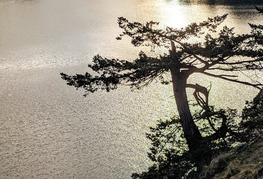 “The snow has not yet left the earth, but spring is already asking to enter your heart.” -- Anton Chekhov Punxsutawney Phil emerged yesterday from his home on Gobbler’s Knob in Pennsylvania and saw his shadow, so winter continues there for six more weeks. Here on Fidalgo, Groundhog Day was cloudy, so our winter is now giving way to spring. At least that’s what I predict; our marmots are still safely sleeping in their dens and unwilling to comment. Kath and I explored our local Gobbler’s Knob, Goose Rock, on the north end of Whidbey Island. The sun was out, the day calm and kind of warm, almost like spring. As we walked the trail east from the park office, our cares sloughed off our shoulders and a joy returned to our steps. We saw dozens of trees fallen from the winter storms. And we saw the new growth of spring, subtle but unmistakable throughout the forest and meadows. Buds were expanding, this spring’s leaves growing within and ready to burst forth to herald a new season. Green growth carpeted the sides of the trail, a salad of plant life celebrating the coming spring. Some mosses underfoot had created a canopy of green a half inch above the dark soil; we looked up and saw a canopy of green a hundred feet above us. It’s all relative. The intimate, close-up details mirror the larger world we live in. We saw huge tree trunks scarred by fire yet still alive and sharing life. They reflect the stories of sorrows from days past, yet a determination to carry on and continue growing upward. We continued upward, climbing the south slope of Goose Rock. The path is steep, a steady climb; our breathing was labored, but the ever-expanding views encouraged us to carry on. At the top, 484 feet above the sea, we caught our breath and soaked up the scenery of Deception Pass and North Whidbey. Beyond we could see the Cascades and Olympics draped in gray, and the Straits below a pageant of blue, with whitecaps riding the waves. An eagle drifted along below us. The bare rocks invited us to sit a spell and savor this special day. Shore pines gloried in the warm afternoon. We gloried in the sunshine and beauty. The madrones, meadows, and rocky balds of the hilltop gave way to deep wet soil, tall firs, salal and sword ferns as we took the northeast trail back down, through the shadows and coolness hidden from the sun, past old growth trees still here centuries after their first spring. Walking along the perimeter trail we got a peek-a-boo view of the bridge, and looked over to the cliffs of Fidalgo Island, then Strawberry Island, then Ben Ure Island. Heading south, the ferns gave way to grasses and sprouts of new flowers. Big billowing puffball clouds reflected sunshine back onto the woods and trail. Soon madrones again filled the forests; buds expanded on huckleberry branches, ready to sprout. The warmth of the sun filled the trail and our hearts. We followed the trail along Cornet Bay and then back to the park office. It’s the halfway point, Imbolc, the middle of winter. We know that winter is just another step in the cycle of life. But sharing here with you, the readers of our hiking blog, and basking in the warmth of our hearths and hearts, I can't imagine a better fate than the remainder of this long and lustrous winter. jack In the midst of hate, I found there was, within me, an invincible love. In the midst of tears, I found there was, within me, an invincible smile. In the midst of chaos, I found there was, within me, an invincible calm. I realized, through it all, that in the midst of winter, I found there was, within me, an invincible summer.” -- Albert Camus Directions: From the Deception Pass Bridge, drive south three quarters of a mile. The park office is on the left, or east side of Highway 20. The trail starts in the turnaround of the parking lot.
By Bike: Highway 20 is narrow in this area, but the shoulders have enough room to ride single file. The bridge has no shoulder at all; plan accordingly. By Bus: Island Transit 411W northbound stops at Seabolts, just below the park office. Southbound it stops near Cornet Bay Road on the west side of Highway 20, a couple hundred yards below the park office. Mobility: The trail is inaccessible for wheelchairs and other mobile devices. The Goose Rock trail is steep and rocky from the south side, a little less steep and mostly packed dirt going up the northwest trail, and steep and filled with roots going up the northeast trail. The Perimeter Trail goes around Goose Rock, but does have some steep sections, with a trail base that is rocky, root-filled, and/or hard-packed dirt. |
Authors
Maribeth Crandell has been a hiking guide in the Pacific NW for over 20 years. She's lived on Whidbey and Fidalgo Island for decades. As a frequent bus rider she easily makes connections between trails and transit. Archives by date
July 2024
Categories
All
|
 RSS Feed
