 Visit State Parks by fare free bus this summer! Island Transit just started their Central Whidbey State Parks bus, only available between Memorial Day and Labor Day. They offered this free service last year, too. I took it twice, once by myself to figure it out, and once with a group of friends. We visited Fort Ebey State Park, Ebey’s Landing, and Fort Casey State Park with 90 minutes at each park and time for a picnic lunch and ice cream in Coupeville. 8:52 Catch the Central Whidbey Parks bus northbound at the Coupeville Park & Ride (across from the Cedar and Salt coffee shop on S. Main Street) 9:15 Arrive at Fort Ebey State Park with 90 minutes to explore (bring a trail map). 10:55 Catch the Parks bus at the Lake Pondilla parking lot. (Near the restrooms.) 11:08 Arrive in Coupeville next to Bayleaf with 90 minutes for lunch. 12:38 Catch the southbound Parks bus at the same stop (by Bayleaf) 12:45 Arrive at Ebey’s Landing with 90 minutes to walk the beach or the bluff (not the whole loop) 2:15 Catch the bus at the sharp curve by the parking lot and go to Fort Casey. 2:25 The bus stops in front of Fort Casey’s big guns (near the restrooms). 2: 35 The bus goes to the ferry, then returns to Fort Casey’s big guns at 2:40. 2:52 The bus arrives at the Coupeville Park & Ride. I live on South Whidbey as do the friends that came along with me last year. So we took the Route 1 Northbound to start our adventure. When we reached Race Road I asked our driver to radio the driver of the State Park bus to make sure we could catch it at the Coupeville Park and Ride. It’s a tight connection. The drivers spoke and we transitioned flawlessly from one bus to the other. Our first stop was at Fort Ebey State Park. We got off at the Entrance Station and walked up the road to the left, then turned right onto the old service road. We passed the Hiker Biker campground and came out near a picnic shelter overlooking the water. Kids were riding bikes in front of the gun battery. The smallest enthusiastically pointed out the entrance. We walked through the tunnel and came out on the other side. We took the trail along the bluff stopping to enjoy the view across the water. The twisted trees told us of blustery winds. We walked until we turned onto the Hokey-Ka-Dodo Trail, then turned right on the Kettle’s Trail, left on the Forest Run Trail, right on the Campground Trail, and left onto the Raider Creek Trail. (Bring a map.) This is my favorite trail in the park alongside a ravine where ferns are lush and birds call from the cedar and alder trees. When we reached the road we turned left and walked a short distance and turned right onto the old entrance road (no cars). We turned left again to walk down toward Lake Pondilla and turned left again onto the Pacific NW Trail. At the road we turned right to meet the bus near the restrooms. Next we took the bus to Coupeville where we occupied a picnic table by the wharf. After sharing our bag lunches, we had time for a walk out to the end of the wharf to see the marine life exhibits and then got ice cream before meeting the bus again. (Restaurants in Coupeville can be busy, so we packed bag lunches.) Our next stop was Ebey’s Landing where we got out and split up. Some climbed the bluff for a good workout. Others strolled the beach for 90 minutes until we collected again at the parking lot to catch the bus on the sharp curve. Then it was off to Fort Casey State Park. The driver let us out for a quick visit to the fort (and the restrooms) while he drove the bus to the ferry and then came back for us. Again, it was a close connection between the State Park bus and the Route 1 Southbound in Coupeville, so we asked the driver to call ahead. We just crossed the street and hopped on the Route 1 bus sharing photos on the ride back home. I look forward to taking more friends on our State Park bus this summer. Of course you don’t have to go to all three State Parks, but it makes a great adventure! Maribeth You can also take the Route 1 bus to South Whidbey State Park and Greenbank Farm. And you can take the 411W bus to Deception Pass State Park seven days a week, year round! For bus info call 360-678-7771 or click here www.islandtransit.org/ For a map of Fort Ebey State Park trails click here Directions: The Central Whidbey State Park bus loops around Central Whidbey with stops in downtown Coupeville, the Coupeville Ferry and three State Parks (See Island Transit schedule for all the stops and times.)
By Bus: Take the bus to reduce your climate footprint and enhance your adventure. Give your bus driver plenty of time to help you make connections between the Park bus and other buses you may need. Mobility: Fort Ebey State Park has many trails that are narrow and hilly. Ebey's Landing provides good beach access, and a short trail at the base of the bluff with restrooms, picnic tables and interpretive signs. Fort Casey State Park has a sidewalk to the gun batteries near the restrooms.
0 Comments
The sun came out and clouds parted for this walk through the Earth Sanctuary. Baby ducks, baby rabbits, new spring shoots everywhere sang out, “It’s spring! It’s spring!” I turned toward the dolman, my favorite of the standing stones, and found iris blooming nearby. I spun the prayer wheel in a sun wise direction and made a plea for peace, for sanity, in our country and in distant lands. Prayer flags fluttered with bright colors against a canopy of green leaves and blue sky. One set of homemade prayer flags in blues and yellows, included a small Ukrainian flag. Others sported red, white and blue stars and stripes. Walking the trail I was surrounded by lush green growth, spring beauty, foam flower and a carpet of lily of the valley bloomed along the trail. Birds sang above me and one persistent robin called again and again in alarm. I stopped and looked, took a few steps forward, took a few steps back. I kept looking but the leafy alders and maples were hiding the sleepy predator. Finally, I stepped off the trail to study the branches of a tall fir tree and there it was, a barred owl just trying to get some shut eye. The robin finally left it alone and it went back to sleep. I’ve been here many times but usually my attention is directed toward the water and a good view of ducks, geese or even a swan once. This time I decided to take the Celestial Trail that climbs high away from the ponds. It was a good leg stretcher and lung expander, out of the alder marsh into a forest of fir and hemlock. Up, up and around and finally I came out in a place I’d never been. There was a map that showed me I was near the Emil Road entrance. Around a corner there was a line of prayer wheels and an impressive Buddhist stupa. Swallows played around a colorful set of prayer flags. Nearby, redwoods had been planted as a memorial for certain people with plaques that bore their names. A red sculpture, a stone owl, and I was back on a trail in the woods. Emerging from the trees I came upon a circle of standing stones. My ancestors from the British Isles would probably approve. I walked around them clockwise uttering another prayer of thanks for this amazing place. Leaving, I spun a nearby prayer wheel and continued on the trail. A bench in the sun invited me to sit down by the water and listen for birds. It was quiet. A cyclist went by on the road with a whirrrr. Ducks paddled placidly among water lilies. Song sparrows sang. Towhees called. A small yellow bird with a jaunty black beret, a Wilson’s Warbler, made a fleeting appearance. I heard black headed grosbeak, chickadees, and juncos. Starting back alongside the pond I noticed a turtle on a stump out in the middle soaking up the sun. This forested wetland, fen, bog, marsh, provides food and shelter, peace and prayer for the whole community, all my relations, those with feet, fur, feathers, flippers and foliage. The trail led me by peace posts with prayers in different languages, seats where one could watch the water, wood duck boxes, and metal osprey on tall spires with the word “Quiet” underneath. Looking up I saw an osprey nest at the top of a tree. All the parts of the puzzle have been preserved here. Thanks to Chuck Pettis and his friends and family who keep it open and maintain the trails. This trail is unlike any other on Whidbey Island. Come quietly and enjoy the peace of spring at the Earth Sanctuary. Maribeth The Earth Sanctuary is open every day during daylight hours. There is a $7 per person entry fee. Payment can be made with cash, check, PayPal, or Venmo ([email protected]). No dogs, please. For more about the Earth Sanctuary click here. Directions: Take Highway 525 to Freeland. Coming from the south, you may turn right on Newman Road and drive about a mile to the Earth Sanctuary sign. Coming from north of Freeland, turn left at the light at Fish Road and follow Main Street to Newman Road. Turn left and drive about 1 mile to the Earth Sanctuary sign on the left.
By Bus or Bike: Take the fare free Island Transit Route 1 bus to Maple Ridge in Freeland and walk one mile east on Newman Road to the Earth Sanctuary. Two bikes fit on a bus bike rack. Newman Road is a quiet, level road with little traffic. Please wear bright clothes when walking or biking by the road. For a bus schedule click here. Mobility: The trails are narrow and slightly hilly. Some short sections close to the parking area are more gentle with benches. 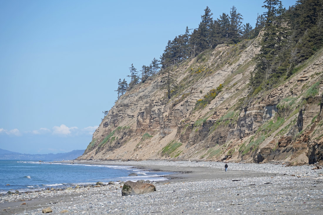 Yep, Californians must dream of being able to hike a beach like this. First there is ample parking – and it’s free, or better yet, you can ride your bike or take the bus here. This is a beach where you will see more whimbrels than people, where you can surf without the music of a beach blanket bingo party in the background, where millionaire homes don’t intrude, where the air is clean and clear, and where snow-covered mountains relax in the background, sharp and inviting. The sound of the surf is the constant soundtrack for the entire two-and-a-half-mile hike in each direction. And the bluffs lining the beach also speak volumes, in muted voices unless we pay close attention. Sixteen thousand years ago, this land was buried under 4000 feet of ice, laboriously grinding south to Olympia, then receding north to Canada and the Cascades. For several thousand years they had scoured Whidbey, then rebuilt it with castoffs from its excavations. These bluffs stand as stark reminders of the flow of time and energy in a world that had cooled just a handful of degrees. The glacier pushed the salt waters of Puget Sound away. When the ice retreated, large lakes formed from meltwater and the many rivers still coming out of the Cascades and Olympics. Most of these lakes disappeared when the glacier retreated up Whidbey, once again allowing the ocean waters of the Strait of Juan de Fuca to fill the waterways we see today. Walls of sand over a hundred feet high line the north half of this beach. These walls erode quickly as wind and waves dig at them relentlessly. The eroded sand fills the beach here and for miles to the north as the currents carry the sand along. Here's a YouTube video of the sand waterfalling down the cliff: https://youtu.be/if_Kqz40rK8 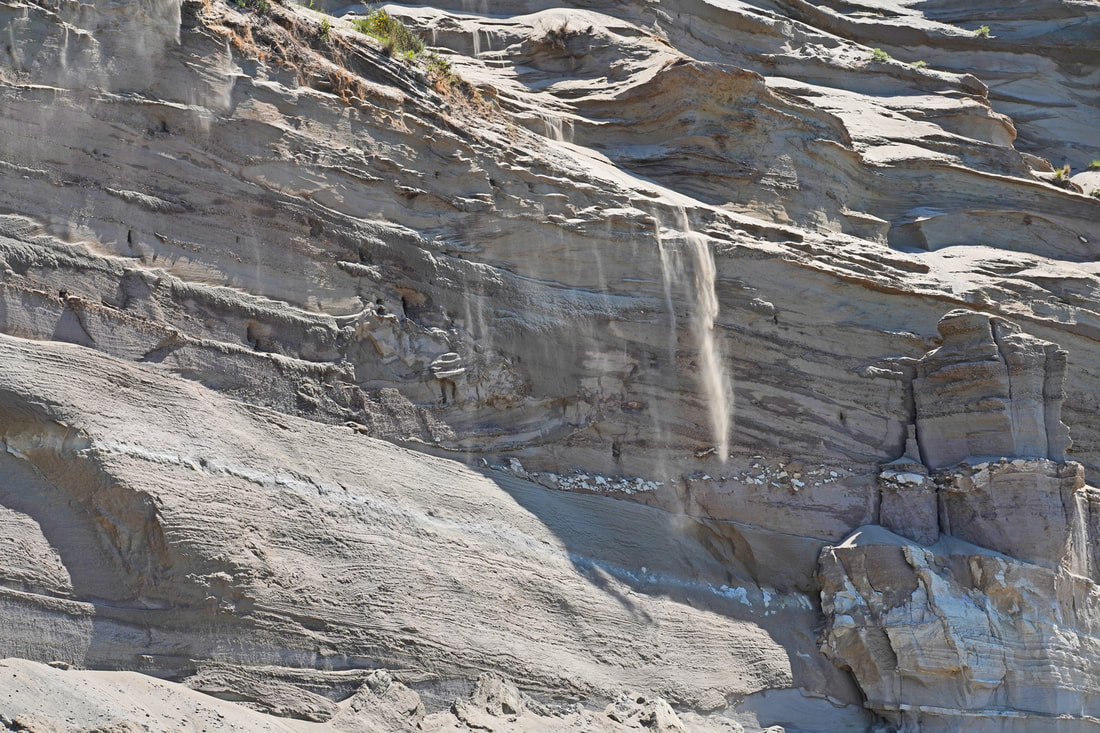 The south half of the bluffs is glacial outwash, the typical glacial till we have all come to know and hate – a texture like gravelly concrete, with larger rocks thrown in as the melting glacier dropped its load of scoured debris. The beach is rocks and gravel beneath these bluffs. The action continues. Waterfalls of sand rained down the bluffs as we walked along. Larger piles of sand lay at the bottom, eaten away with each high tide. Further down, a large cabin-sized slump of glacial till had broken off the bluff. Hopefully, no one is underneath when this happens again, which it will! We played leapfrog with the whimbrels, marveled at the flight of seagulls, and watched crows shoo an eagle out of ‘their’ neighborhood. Surfers waited just offshore for good curls to ride back in. The south end of the beach has a house built out into the shoreline, requiring a rock riprap wall to protect it from waves, temporarily. You can only get around this obstruction with a tide of less than four feet. The tide was rising, almost at four feet now. Another hour and I would have been too late. We were back at our car, ready for a snack, and one last look over the entire stretch of coastline we had just hiked. The sandy strand still beckoned, a world apart from the busyness of our normal lives. The sunshine and warmth made us smile. Waves rolled in with their steady soothing surf song. The islands and mountains in the background made it all seem so dreamy. Dream on, Californians. jack Directions: From Highway 20, 4.4 miles south of Oak Harbor, or 6.4 miles north of Coupeville, turn north onto Hastie Lake Road and drive to Hastie Lake Beach Park. Or park at West Beach County Park on West Beach Road at the north end of this hike.
By Transit: Take Route 6 which follows West Beach Road near here. By Bike: the roads in this area are rolling with an occasional steep section. They are somewhat high speed, with minimal shoulder, but low volume. Mobility: the beach is a mixture of sand, gravel, and small boulders. Note: Check your tide calendar! There is NO place to get above a full high tide for most of this beach, especially in the winter. And the tide must be below the four foot level to get around the rock rip rap at the south end, and to make for easier walking at the north end.  Watch the YouTube video of the hike first to get a better feel for the experience of the trail. Click here for the video. Put it on a bigger screen than your phone, for sure; then turn up the volume, sit back and immerse yourself in this world for four minutes. "Land is not merely soil, it is a fountain of energy flowing through a circuit of soils, plants, and animals.” – Aldo Leopold “The soil is the great connector of lives, the source and destination of all. Without proper care for it we can have no community, because without proper care we can have no life.” ― Wendell Berry Cow poop. That’s the first odor to reach my nose. Or is it freshly turned compost? No difference between them, really, not in my nose anyway. Thus I began hiking the Beach View Farm Trail. The trail accentuates all four words of its name, with a magnificent beach at the far end of the hike, a big sky and ocean view for the entire route, and farmland on both sides of the trail for much of the hike. Bookending it all are wetlands, forests, scattered homes, and native habitats for an incredible diversity of life, both wild and domestic. I find this trail to be my meditative place, my grounding place, my reminder that my life, and yours, is totally dependent each day on the earth and sea being healthy enough to grow what we need, and totally dependent on certain people to gather what is grown so that we may live yet another day. So it was on this day in early May that Kath dropped me off at the east end, near the church, to let me wander down the trail slowly, lost in thought and wonder. Wonder. That quality that senses the magic, the miracle, in all that is around us and within us, every day. An eagle calling to its mate, a dandelion cypsela ready to launch, a hundred shades of spring green leaves bursting forth, and songbirds serenading their heartfelt melodies – what a gift to be known by your song, right? I watched a heron for several minutes as it moved all of two inches along a waterway, focused on its next meal. Big beefy cattle ruminated about life inside a fence, while a doe did the same walking freely through the meadow nearby. Geese swam with their next generation, and red-winged blackbirds looked for a mate to create the next generation. The Timothy grass grew, a fertile fountain of energy fed by the life-giving sun and soil. Chickens dined on whatever insects they found in the field, and then fertilized the farm soil with their droppings. Yes, there is poop – it happens. It’s a farm, it’s real, and it’s essential. Did you know that in the year 1800, 94% of our nation lived in a rural setting? A trip to town was about buying staples, not groceries. In fact, the first grocery store would not open until 1916. Where was all the food? It was in homes, gardens, local fields, and forests. It was in the pantry, the cellar, the backyard. By 1900, just 40% of our citizens were farmers. Today, that number is down to just… just 1%. I met up with Kath where the trail enters Swantown Lake County Park, and we wandered the trails through the forested meadows and near the wetlands of the lake. Sprinkles began to fall. I looked back across the entire trail I had just hiked. Peace reigned. The circle of life rolled on. jack “To forget how to dig the earth and to tend the soil is to forget ourselves.” – Mahatma Gandhi “The care of the Earth is our most ancient, most worthy, and most pleasing responsibility. To cherish what remains of it and foster its renewal is our only hope.” – Wendell Berry __________________________________________________________________________________________________ Directions: From Highway 20 south of Oak Harbor, take Swantown Road 1.4 miles northwest to Wieldraayer Road. Turn into the Christian Reformed Church parking lot; use one of the 8 parking stalls on the lower end of the lot, devoted to trail users, which heads west from here along the road to the trail. Or, park at the West Beach County Park on West Beach Road and walk south 300 feet to a gravel road that leads to Swantown Lake County Park, which is the west end of the Beach View Farm Trail. By Bus: Route 6 connects Coupeville with Oak Harbor by traveling along West Beach Road. By Bike: the roads in this area are mostly low-volume, and hilly, and with narrow shoulders. West Beach Road is high-speed in places. Mobility: the trail is mostly compact gravel through the farmland, fairly wide and gently sloped. The trails through the county park are narrow, generally soft and grassy, and also gently sloped. Dogs: Pets are NOT allowed on the Beach View Farm Trail; they ARE allowed in Swantown Lake County Park if they are always on a leash. That is why Murphy is not in the movie until the very end. |
Authors
Maribeth Crandell has been a hiking guide in the Pacific NW for over 20 years. She's lived on Whidbey and Fidalgo Island for decades. As a frequent bus rider she easily makes connections between trails and transit. Archives by date
July 2024
Categories
All
|


 RSS Feed
