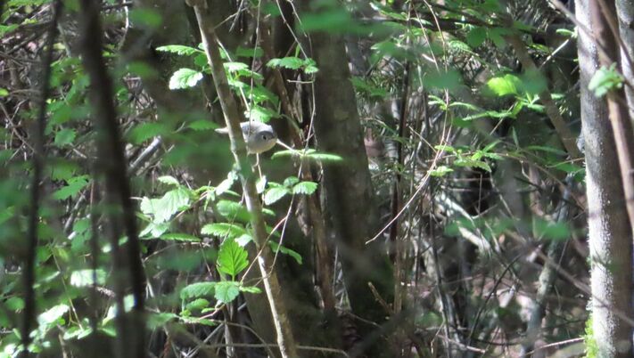
 When people ask me “What’s your favorite trail?” I used to think of the Ebey’s Bluff Trail. It is stunningly beautiful with expansive views of the water and mountains, a beach walk and ridge hike in one. But over the years I find myself gravitating to the lesser-known Pratt Loop Trail that stands meekly in its shadow. My sister, Sue, was one of the most popular girls in school. She always dressed well and wore her hair and make-up tastefully. She hung out with the cheerleaders and football stars. I came along a few years later, a little sloppy and shy. I was known as Sue’s little sister. Early last Saturday morning, I drove past the Sunnyside Cemetery and parked behind the Ebey’s Landing National Historical Reserve office. I turned away from the Bluff Trail toward the Pratt Loop Trail, and began to think about it metaphorically. The Ebey’s Bluff Trail is probably the most popular trail on the Island. The Pratt Loop is not so showy and often overlooked. You have to get to know it before you really appreciate it. I love to walk there on spring mornings with my ears and eyes open, looking for birds. Heading north from the parking lot, I could peer over the shrubs at the blockhouse in the cemetery next door. Indian plum and Oregon grape bloomed adding color to the thicket of wild rose in the hedgerow. The sun shone brightly. Birds were singing. Cows were lulling around on the pasture next door. I carried binoculars around my neck and a camera in my pocket. Hummingbirds posed briefly at the tippy top of an elderberry. A savannah sparrow perched on a slender, yellow flower. The old snag that used to stand in the middle of the field has finally fallen. It lays on its side still serving as a centerpiece. At the historic barn, I stopped at the map to see the connections with the Kettle Spur Trail and traced my route around to the loop to the Ridge Trail that would take me by the Sarah and Jacob Ebey cabin and back to the trailhead. Standing at the edge of the forest, I could hear woodland birds calling, a nuthatch, woodpeckers, and chickadees. Flickers drummed on the tallest snag waking up the neighborhood just like they do on streetlights and chimneys. Golden crowned kinglets dove into the ocean spray that form a canopy along the trail. Hummingbirds were humming, warblers were warbling, and woodpeckers were pecking. I walked ahead and then came back, following their calls, trying to get a look at some of these songsters. A jogger passed by. A few minutes later, he returned. I grinned as both of us were going around in circles. The trail weaves into the woods, then out to the field, then back into the woods, deep shade, bright sun, deep shade, like a swimmer rising to the surface, taking a breath, and submerging again. Field, forest, field, forest until one reaches the far side of the pool and climbs out. The warm sun shines and distant mountains come into view. I followed the trail across the fields as views of Puget Sound and Ebey’s Prairie unfurled before me. Turning toward the Sarah and Jacob Ebey cabin, hordes of people appeared headed toward the Bluff Trail. First a group of twenty chattering away, then a group of ten, and right after them, a group of seven. But who’s counting? I’m happy to have a quiet walk on the Pratt Loop seeing only a few other people in the hour I spent there, but many more birds. After they’d passed the cabin and the quiet returned, I got pictures of a chipping sparrow and red winged blackbirds. I was happy with my walk and all the birds I'd seen and photographed. Rounding the bend toward the parking lot, I heard quail and saw them scurry beneath the hedge. They’re a little shy. I can relate. Maribeth Ebey's Landing National Historical Reserve is cooperatively managed by the National Parks, State Parks, Island County and the Town of Coupeville. The Pratt Loop is just a small part of the 17,000 acre reserve. Learn more here. Directions: From the stoplight on Highway 20 in Coupeville go northwest 1 mile and turn south on Sherman Road. In half a mile turn right on Cemetery Road. The parking area is at the very end. Go slowly on this single lane blind curve. Restrooms are at the trailhead. Dogs must be on a leash and bring a bag for pet waste.
Bus and Bike: The nearest bus stop is at Sherman Road less than a mile away. Take Island Transit Route 1 Monday-Saturday. There is a paved bike path that parallels the highway for 4 miles from Rhododendron Park to the Kettles Trails near Fort Ebey State Park. The Kettles Spur trail connects this paved bike path with the Pratt Loop Trail. Bikes are not allowed on the trail but a bike rack is provided by the bike path. 2-3 bikes fit on an Island Transit bus. Mobility: The Pratt Loop is flat and most of it is on farm roads that are easy to walk or ride with a mobility device. As the trail enters the woods there are more roots and the trail narrows but is not rough. The loop 1.3 miles long.
0 Comments
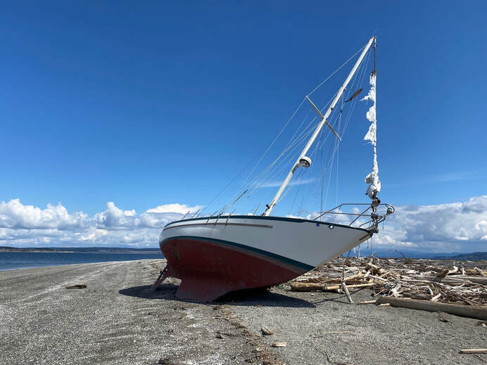 I’d just heard on the car radio that it was the anniversary of the sinking of the Titanic (April 15, 1912). Then I arrived at Long Point and found this, a ship had floundered on the beach, flags still flapping in the brisk spring breeze. I scanned the water for icebergs. Though spring has been long in coming, on this day the sun shone brightly and sent puffy white clouds sailing across the deep, blue sky. I approached the stranded vessel trying to imagine it's mishap. Had it broken loose of its mooring and washed ashore with no one aboard? Were the sailors unaware of this long point at high tide despite the name on a chart? Had the wind been overpowering, the current too strong to avoid sailing onto the beach? At least, it was a low, sandy beach and not a rocky, inaccessible bluff. No harm done, not much anyway, except the embarrassment of your sailboat lying up on the beach for all to see. It reminded me of how I’d almost suffered the same fate once just north of here. A strong wind from an unexpected quarter, drug us off our quiet anchorage late at night. We were in an historic long boat powered only by oars and sails. It was dark. The wind was howling. Waves were pounding our little vessel. We radioed “May Day”, donned our survival suits and were rescued near Deception Pass. But this day was bright and promising. It was low tide and I was out for a relatively uneventful walk between Long Point and Coupeville. No life rings or survival suits necessary. There was plenty of sunshine and white sand though a cool breeze kept me bundled up in all my layers. I made my way westward. Beyond the beautiful waterfront homes the bluff rose high up on my left. A few trees grew just above the sand trying to hold on to the sluffing soil. Maples were leafing out in their chartreuse party dresses showing off their dangly earrings. A few trees had tipped over and I was glad I had a wide beach to navigate around them. If the tide were higher, it would be quite the logstacle course. I approached a little spring trickling out across the sand where bright green algae grew. A perfect place for otters, I thought, and I looked for tracks. Instead I was accosted by kingfishers rattling around me. Eagles called from the tree tops high above. One called to another as a third cruised by. Ravens croaked from the forest. Hummingbirds zipped to red flowering currant. Mergansers, goldeneyes and eared grebes paddled just offshore. Gulls and crows hopped along the water’s edge picking up bivalves, lifting off and dropping them on the beach. Crack! It was an all-you-can-eat buffet of mussels and clams. I was getting hungry, too. I passed another cluster of beach cabins. These were more modest and looked like they had some history. When I was here last summer, people were out cleaning kayaks, roasting hot dogs and marshmallows. I walked on and again the bluff rose above me. Around the corner my favorite house came into view. It looks like the home of a pirate, or a wizard, or some other whimsical creature, with its red cap and green cape. That's where I turned around, within sight of Captain Coupe Park with it's boat launch, dock and picnic table. I took a picture of the Coupeville Wharf and headed back. I could hear the subtle swish of the tide changing and didn’t want to get stranded somewhere along the way with the high bluff towering over me and not enough life boats. Maribeth Directions: This beach can be accessed from the Captain Coupe Park on 9th Street in Coupeville, 6 blocks east of Main Street. Or from the stoplight at Main Street and Highway 20, drive south 2.7 miles to Morris Road. Turn left and take a quick left onto Parker Road. Drive 1.3 miles and turn right on Portal Place. In a short distance turn left on Marine Drive and follow it to the end.
Bus and Bike: Fare free Island Transit route 1 and route 6 go through Coupeville on Main Street. You may get off at the Methodist Church and walk or ride east 6 blocks on 8th (a quieter street for pedestrians and bikes), then hop north 1 block on Gould to 9th and go one more block east to Captain Coupe Park. Walk east on the beach. Mobility: The Long Point end of this walk is a soft, sandy beach. However, there are driftwood logs and the beach sand is too soft for most wheels. The beach gets rockier as you go toward Coupeville. Captain Coupe Park has a dock, boat launch, picnic table, barbeque and restrooms on a gently sloping lawn. 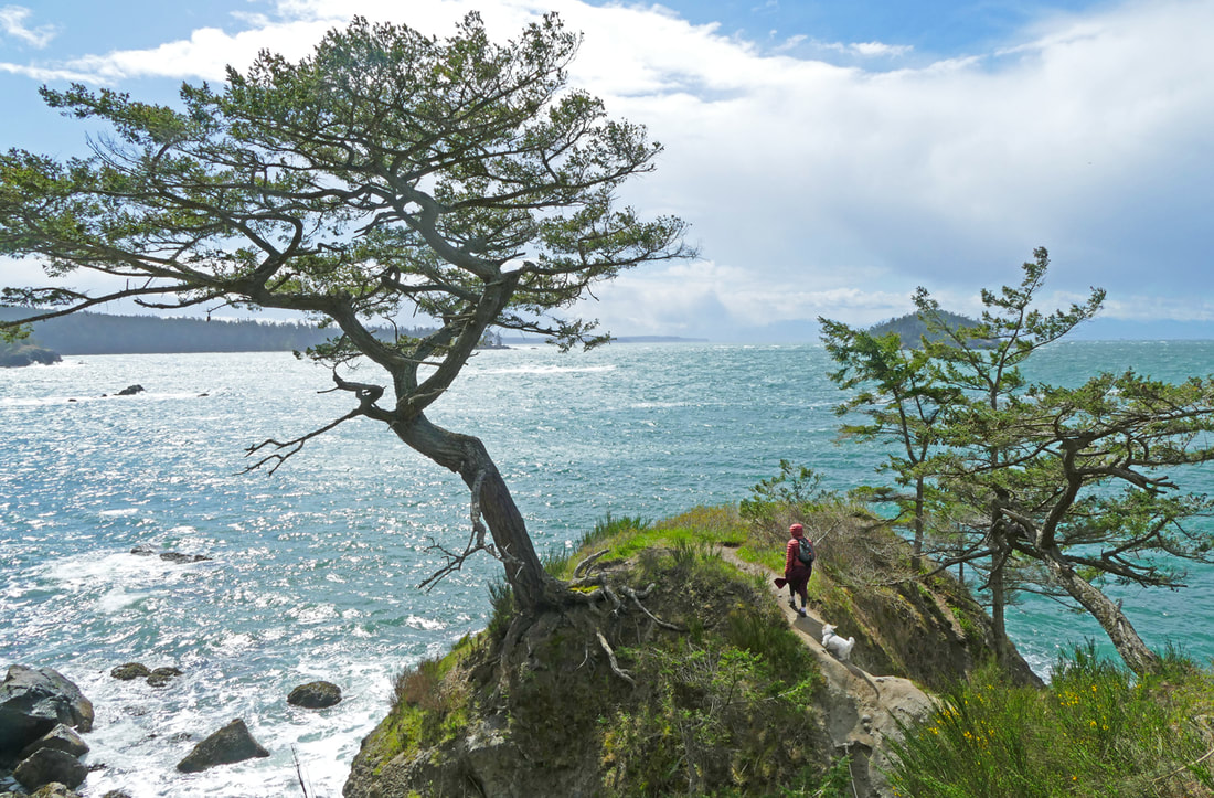 Fun! That’s what our hike was, pure fun! The wind blew strong out of the west, not its usual direction. The sun shone brightly, sparkling in the wind-scrubbed sky. The air was warm…ish. “Where should we hike?” I asked Kath. “Somewhere fun,” she replied, and we both said “Bowman Bay and Rosario!” Emerson the elephant seal was still lounging around the parking lot at Bowman Bay. Park staff had tried to open the parking lot for visitors, but Emerson delighted in waddling over to cars, oblivious to the law that we all have to stay a hundred yards away from him. And then he just plopped himself down in the middle of the lot and took a nap, so the lower parking area was closed once again. The beaches are now open, but who knows where he will wander, so be flexible if you go there in the next couple of weeks. A big thank you to all the volunteers who help teach us about Emerson’s habits and capture the stories and photos of his childhood antics. When we arrived, Elizabeth Drozda and Jann Ledbetter were on hand near the boat launch, telling stories about him, sharing photos, and reminding visitors of the need to give him space. I took my photo of him with a telephoto lens from a proper distance. But the sun and wind continued to beckon. Kath and I wandered down to the beach. Waves rolled in from the Strait, sparkling in their blue and white. The gravel glistened, seagulls turned on the wind, children and dogs and an adult or two cavorted and ran and played, feeling like spring is back if just for a day. We climbed the bank to the Bowman - Rosario trail and looked back over the expanse of Bowman Bay, spread out like a welcome mat before us, waves rolling in. We’ll be back soon, we said, not realizing how many more pleasures awaited ahead. We hiked up the short but steep trail, seeing ferns dancing in the wind, trees waving their arms, silhouetted by the shimmering waters of the bay. People passed in clumps of two or three, smiles on their faces. We came to the tree that needs a name, alone on a promontory near Rosario, and we lay in the small bowl at the point, perfectly sized for two people and a dog to lie down and soak up the sun out of the wind. Waves crashed all around us. Bees busied themselves on newly-emerged flowers. The sun beamed down. After a joyful rest, we finished the hike to Rosario, the green grass inviting picnics and playfulness. The isthmus to Rosario hummed with people. We walked onto the dock and rode the floats like a rollercoaster, the waves rising and falling beneath us, keeping us dancing. KoKwalAlWoot watched stoically, a look of wisdom on her face, and maybe a twinkle in her eye. We followed the gentle south trail to the top of Rosario, as a glaucous-winged gull flew along nearby, loving the eddy of a breeze. At the top I unzipped my coat and raised it over my head like a sail, letting the winds pick me up off my feet a little. (Obviously, do not do this near the edge.) Waves pounded the base of Rosario; oystercatchers squawked and laughed on the rocks offshore. The blues and whites of the sea were achingly beautiful. Time lost all meaning as we hung out, but it was a tad cold up there, so we headed back down, watching Harlequin ducks playing in the surfline. We retraced our steps back toward Rosario, playing leapfrog with other hikers who, like us, would walk a ways, then stop to enjoy the amazing day. Eventually we dropped back down to Bowman, the sun still a welcome friend, the wind a playful partner, the sparkle of the day unforgettable. jack https://youtu.be/QCTEPhJa5VQ A one-minute video of some of that sparkle. Directions: From the Deception Pass Bridge, drive north a half mile, turn left at Rosario Road, and immediately turn left again into Bowman Bay.
By Bus: There is no direct bus service; Island Transit does stop near Cornet Bay Road a mile and a half south of Bowman Bay. By bike: Highway 20 has narrow shoulders in this area, and mostly high speed limits. Rosario Road has lower speed limits, but also has narrow shoulders. Mobility: Bowman Bay has a flat graveled trail along the waterfront, as does Rosario. The trail between the two is somewhat steep and filled with rocks and roots. 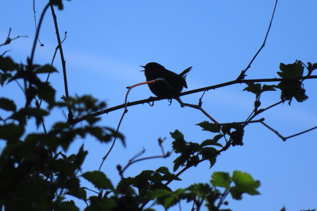 If you don’t like songbirds, wildflowers or expansive views of the Olympic Mountains across the water, don’t come to Admiralty Inlet Preserve. Especially in spring! And by all means DON’T volunteer to help do restoration work with the likes of Kyle from Whidbey Camano Land Trust and his motely crew. Especially on a sunny, beautiful, day in April! You would have an endless supply of little tufts of grass to plant among all the other little tufts of grass, flats and flats of fescue. At the end of the day you’d step back to admire your work and not be able to tell if you were there at all! They call it restoring the native prairie! I went for a walk there and found some honest-to-god flowers at the edge of the bluff. Daffodils! I don't suppose they're native but they are cheery after a long winter. I couldn’t pick them because of the fence between me and the bluff. It’s a long way down and I guess they think some idiot would get too near the edge and just tumble on over never to be seen or heard from again. As I stood there, I could hear a wave rolling down the beach from Ebey’s Bluff all the way to the Coupeville Ferry. But I couldn’t see it because it was straight down! There were swallows shooting straight up from below the bluff, rocketing over my head, turning and dropping back down again. It looked like fun... if you have wings. Of course there’s mud on the trail, here and there. I haven’t been on a trail in months that didn’t have mud somewhere. You just have to toughen up and soldier on. I admit that split rail fence all along the loop trail adds some rustic charm, but it also gives those noisy birds a place to perch and sing their tiny avian hearts out. If you scare them off they just fly up into the nearest tree, or hide in a thicket and pick up right where they left off. The same song over and over and over again! And careful! Those cottontails are constantly zig zagging across the trail when you least expect it. They dart out from under the hedges of wild rose and berry bushes intentionally trying to trip you up. Or those pesky chipmunks that scurry around in the woods. They look so cute until you pull out your camera, then shazzzam! They’re gone! And another thing, the parking lot across the road is blocked with orange cones. Huge earth-moving machines are expanding the parking area, so there’s no place to park right now! Never mind that there’s a fare free Route 6 bus that comes right by the trail every other hour Monday through Friday. If you ask the driver they can stop by that bright blue house across the road from the trailhead kiosk that’s hiding behind the hedge. On Saturdays the Route 1 bus will bring you to the Fort Casey Inn, which is pretty close. But of course, people would rather drive, even though gas is so expensive. Curiously, I saw a group of teenagers riding by on bicycles and they were actually smiling. I stopped to visit with the volunteers for a few minutes, nice enough folks, with their sloppy clothes, sun hats and knee pads. But when they noticed the eagles circling overhead, and then a hawk chasing after them, all work stopped! Hard to find good help these days. Volunteers are adopting trails and cleaning up beaches all over the place for Whidbey Earth and Ocean Month. Some keep at it all year round! I certainly hope they find better places to work than this, on a warm, sunny day, in the spring, with distracting views of the mountains across the water, eagles soaring overhead and songbirds singing from every tree, planting flats and flats of fescue and leaving the place as if no one had been there at all! Maribeth For more Whidbey Earth and Ocean month activities click here. For more about Whidbey Camano Land Trust click here. Directions: From Hwy 20 stop light in Coupeville, turn south on Main Street and go 3 miles. The name of the road changes to Engle Road. The parking area will be on the left and two or three trailheads are across the street on the right (on the water side). Look for the split rail fence. Trail maps are displayed at trailhead kiosks.
By Bus and Bike: The Island Transit fare free route 6 bus passes this Preserve Monday -Friday. The Route 1 comes as close at the Fort Casey Inn a short walk to the south. From the Fort Casey Inn follow the split rail fence up the hill. Look for trailheads with kiosks. There is a bike rack at the trailhead to the southeast end of the Preserve. Biking around nearby Crockett Lake is very popular. The Preserve is 1.5 miles north of the Coupeville ferry terminal on Engle Road. Mobility: This trail is flat and easy to walk except for a few muddy places and some stairs. There are a few benches along the way. |
Authors
Maribeth Crandell has been a hiking guide in the Pacific NW for over 20 years. She's lived on Whidbey and Fidalgo Island for decades. As a frequent bus rider she easily makes connections between trails and transit. Archives by date
July 2024
Categories
All
|
 RSS Feed
