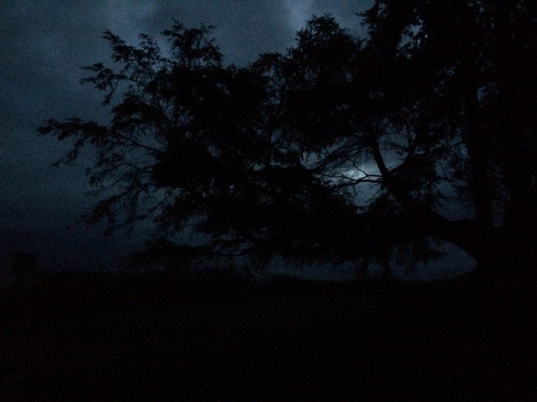
 I worked late, forgetting that the later bus didn’t go by my house on Smugglers Cove Road but stayed on the highway. No problem. I’d just ask the driver to drop me off at Pacific Dogwood and I’d walk home through Trillium Woods. I’d often walked this way last summer. Though the days are shorter now and darkness falls sooner, I was sure I’d make it home alright. I walked the quiet, paved road at the start. A swoosh went over my head, a raven called. As I stepped around the gate and entered the forest a heavy fog crept in. Still I wasn’t worried. There was just enough light and Patrick’s Way is easy to follow. Suddenly, I remembered that Trillium Woods is open to hunters in the fall. Maybe I should’ve stopped at the kiosk where the dates were probably posted. But there were no vehicles, so no hunters, right? I walked ahead passing the little signposts for the Smugglers, Wild Berry and Dragonfly trails. I’d always enjoyed walking home this way on a bright summer afternoon, but in late October it was getting dark much more quickly than I’d expected. Turning the bend I saw the full moon weaving between tree branches and ducking in and out of clouds and fog. I thought I heard footsteps coming up behind me. Looking around the fog was so thick I could only see a few yards away. Those weren’t footsteps. They were horse’s hooves. How unusual to meet someone riding at this hour. A dark shape was approaching. Out of the mist came a shaggy little pony all alone. It must have gotten out of its pen somewhere nearby. It came up in a friendly manner and let me stroke its neck. I remembered an apple I had left over from lunch and offered it to the pony. His lips rolled back as his big, yellow teeth parted to take the fruit. He snatched it from my hand and expertly broke it into bits. We seemed to be going in the same direction, so we continued down the path together. He seemed happy to have some company out here in the woods on this moonlit night. To tell the truth, I was glad to have company, too. Somewhere nearby an owl hooted. I spun toward the sound and then quickened my pace. The pony just laughed and nodded its head. Then a rustling came from the brush and a white buck leapt out with towering antlers. It stopped in the middle of the trail and looked straight at me. The moonlight shone in his eyes. I froze, terrified. But the fog moved in and enveloped the ghostly beast and it was gone. I took a few hesitant steps forward, but saw no sign. We cautiously moved on. I was afraid I’d miss my turn in the dark and fog. By now I was anxious to get out of these woods and home to my warm fire. I sensed I was getting close when the mist parted and there appeared a small boy leaning on the signpost. He was thin and pale and wore a long green coat and strange red hat. His head drooped as if he were tired or defeated. As we approached I started to greet him when he suddenly turned and pointed. He snarled in a deep voice. “You stole my pony!” It was not a boy but an old man with a long beard. I was stunned. He drew a long knife from his waist coat and shouted, “Defend yourself or die!” When I stopped running I was on my porch shaking so badly I could barely get my key to turn in the lock. I rushed inside, bolted the door and turned on the lights. Outside I heard laughter in the moonlight and the clomping of hooves trotting away. Maribeth Directions: Don't go into the woods at night no matter what!
However, if you wait until daylight, and not hunting season (unless you're a hunter), you can find Trillium Woods by taking the Route 1 Bus southbound to Smugglers Cove Road, 1 mile south of South Whidbey State Park. Or take the Route 1 Southbound on Highway 525 to Pacific Dogwood (just south of the Classic Road telephone booth). For the ADA Loop Trail, take Highway 525 to Mutiny Bay Road 2.5 miles north of Freeland, turn south and then turn right on Bounty Loop Road. The trailhead will be at the base of the hill. (No enchanted ponies were harmed in the making of this blog.)
0 Comments
1 comment: What a lovely and evocative experience, accompanying you on your day and night explorations. Thank you for the gift of your words and photographs, Jack. Sarah S. 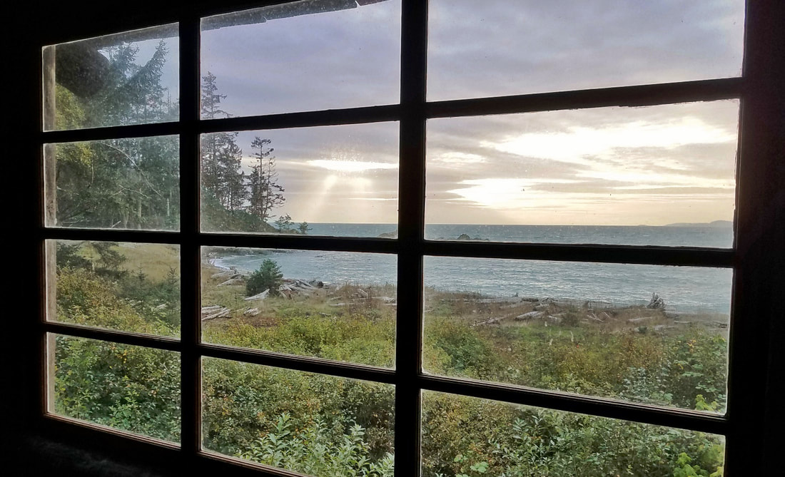 Seize the Day... Strong winds and waves rushed out of the west straight into the headlands of Rosario and then into Bowman Bay. A good day to hike from Bowman to Rosario, which also meant bundling up and donning wool hats and layers and layers of clothing. Walking the trail into Rosario means entering a sacred place. Being close to Halloween, the ancient wood and stone buildings suggested good haunts for scary stories, but mostly they just speak of good places to gather and share food with family and friends. Families were taking quick snapshots of themselves at the isthmus; one man was learning the story of KoKwalAlWoot at the story pole; a young couple at the top of Rosario was having their portraits taken for an upcoming wedding; and two wetsuit-clad swimmers looked like seals in the water among the rocks near the tidepools. Looking over the edge of Rosario, the wind pushed back with powerful hands. The sun fought weakly to break through the hazy clouds to the west. Waves with whitecaps rolled into Bowman Bay or crashed fully spent onto Rosario Beach. Eventually it was time to wander back down the gentle path on the south side of Rosario Head, slipping out of the storm and sauntering back to Bowman. The sun had seen enough of this day and choose to go out in a blaze of glory. Then Evening Falls... 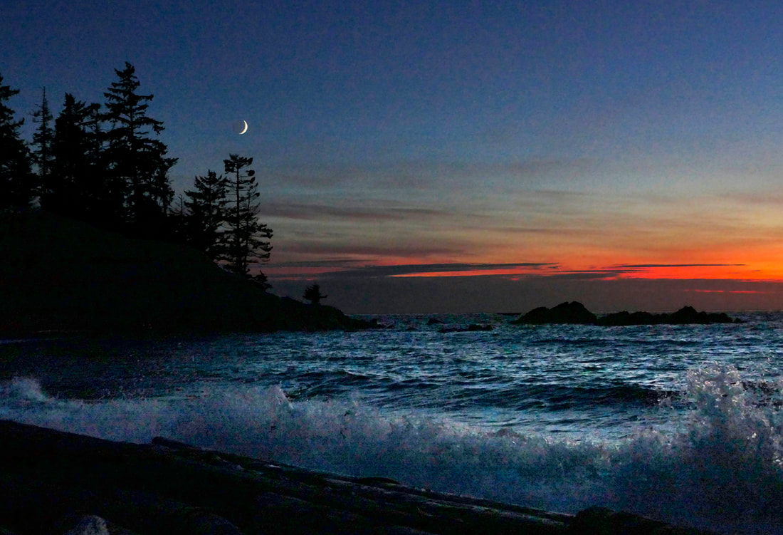 So I returned to Rosario. The sun had now set. The celebratory colors still lingered over the Strait. A sliver of silver moon hung out above Rosario, the rest of its body hinted at by the light of earthshine. The wind had faded a little along with the light, leaving the residual heavy swells booming into Rosario Beach as reminders of this afternoon’s windstorm. A couple of cars remained in the parking lot, a handful of people catching the last rays of the day in this golden hour, or pink hour now, the hour of romance and rememberings, not wanting to go gentle into that good night. As a ranger closed the gates, I asked for permission to return later, in the wee hours, to see Rosario at night, at low tide, at rest. She said sure. ... Into the Night 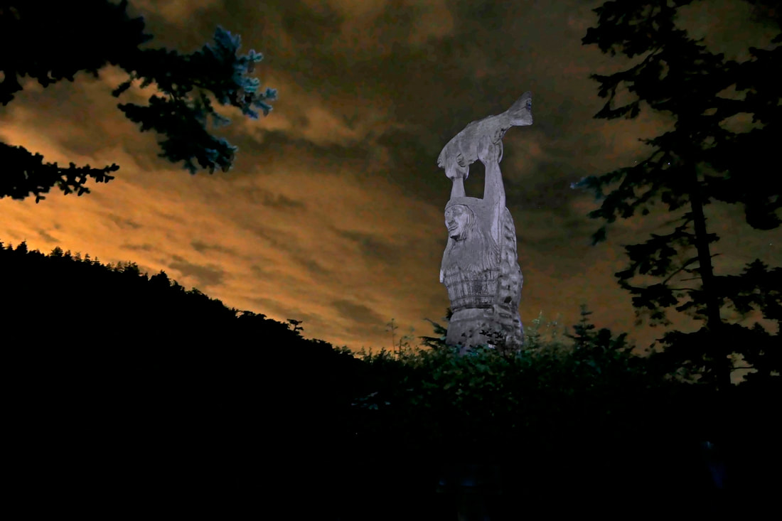 Oh-dark-early. Low tide. Moon gone. Still waters. Starlight and silence. I wander down to the beach, letting my eyes adjust, my mind relax, and my heart come to life. Orange-red Mars hangs above Rosario Head. Lights from the Rosario neighborhood homes reflect off the water. I want to explore the life in the tide pools, but instead become absorbed by the lights of Orion, of the Pleiades, of Vega setting, and now Sirius rising. A heron squawks as she looks for new feeding grounds, splitting the silence for a few moments, and then Rosario settles down again into the living darkness. Back in town at this hour, housekeepers prepare vacated hospital rooms, bakers heat up their ovens, police follow a weaving driver, a shipyard worker takes a smoke break, a stocker refills the shelves of the grocery store, a rejected lover walks the streets looking for solace, a frazzled mother feeds her hungry crying newborn with joy and warmth. At Rosario, I am alone with the stars and the sea, the woods and the whispering quiet. KoKwalAlWoot stands here day and night. They are all the same to her. People come and go, the sun and stars take their turns in the heavens, the waters swirl and slide along their paths. She stands every day, every night, watching it all. I hang out for a couple hours, my spirit still, at peace, absorbing this place of beauty whether by day or by night. The earth turns, a small but special part of the universe that sings all around us every hour of every day. I think to myself I should go home. And then I realize I already am. jack Directions: Just north of the Deception Pass Bridge, turn north on Rosario Road. Drive three-quarters of a mile and angle left onto Cougar Gap Road which heads down the hill off of Rosario Road. Turn left at the T-intersection onto Rosario Beach Road and follow this road to the parking lot. Or you can hike to Rosario from Bowman Bay, a half mile hike each way.
Park hours are basically dawn to dusk. Valid Parking Pass required at Rosario Beach and at Bowman Bay. 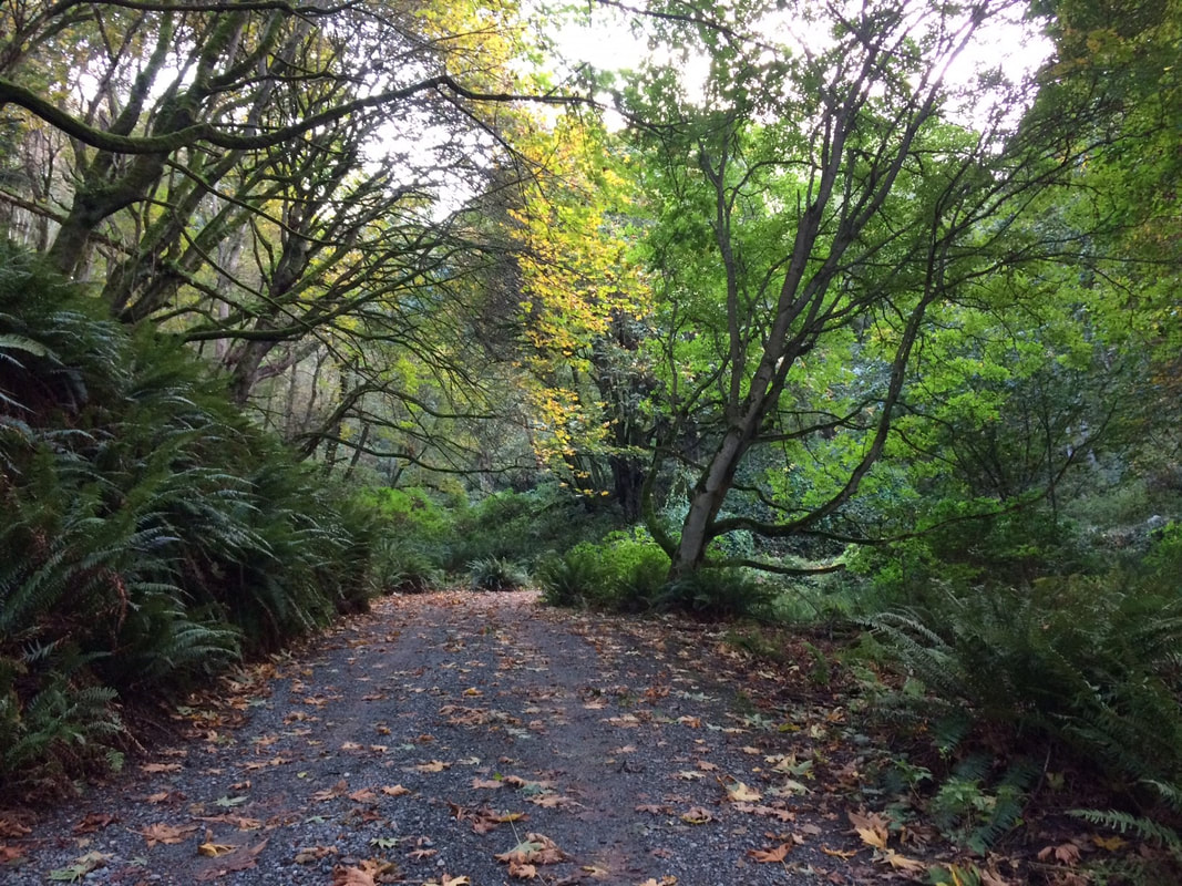 This time of year I go looking for leaves. I suppose it’s my Appalachian upbringing that makes me long for color in the fall. You could drive into the Olympics to see vine maples, or high into the Cascades to look for larch. Here on the Islands we have Big Leaf Maples. I try to think of trails where I could find them in abundance, not just for the color, but for kicking, fluffing and wading through ankle deep. And their wide hollow trunks look like homes for elves which puts me in a mood for Halloween. I traveled to the south end of Whidbey Island to Possession Point State Park on a sunny afternoon this week. There were six cars in the parking lot when I arrived which surprised me for late on a weekday. Yet, I only passed one other person on the trail. I’m glad I remembered my walking stick for this hike which went up immediately from the parking lot, but then went down and up and over and around and through and under and up again. It had rained hard the day before but the leaves on top were crispy and dry. I plowed through them while making my way under the broad canopy of outstretched trees. I stopped to catch my breath and listen. The small parachutes drifted in mid-air. I felt as if I were floating, too, from the tops of the maples down into the ravine below. The steep slopes were covered with wall to wall sword ferns. Licorice ferns preferred to grow in the trees. There was the scolding of Douglas Squirrels, the hoarse honking of herons, and an occasional eagle squeaking from the top of the ridge. This bowl shaped landscape kept me going round and up and ducking under logs and over roots and climbing ever higher for a look from the rim. Emerging from the shady forest into the sun I gazed across the wide blue expanse of Puget Sound. Leaning on the railing, I took it all in. The little white ferry left Kingston and met another coming from Edmonds. A buoy rang as it rocked on the water. Sea lions roared and laughed as they climbed aboard. A tugboat pulled a barge in the distance. A train whistled as it made its way along the shore. Starting down the same path I’d come up, I soon veered right on a short cut toward the beach. On the way, I came across three twisted Yew trees. They have peeling bark and sprawling limbs. They’re slow growing and scattered apart, so they’re easy to miss, but so full of magic. I leaned against one and closed my eyes and felt it humming. Pacific Yew is a natural source of taxol which stops certain cancers from growing. Yews grow so slowly and are so rare that we’d never be able to harvest enough taxol to meet the needs of all the cancer patients, so scientists learned to synthesize it in the lab. So these yew on the trail keep climbing, twisting and humming in this seldom seen corner of the forest blending in as if they were nothing special, when, in fact, they are modest miracle workers. The trail spilled out on a carpet of leaves behind the wood shed near the beach house. I walked across the wide lawn toward the shore all in shadow on this side of the bluff. To the north the Clinton and Mukilteo ferries crossed sides. I paused on a beach log to have a look around. At my feet was a mosaic of tiny twigs, broken shells and smooth rocks, the result of many high tides and storms. I took one last look across the water then turned to walk the road back up to the car under a canopy of golden maple leaves. Maribeth Directions: Take Highway 525 to Ken’s Korner shopping center 2.7 miles from Clinton and turn south on Cultus Bay Road. Stay on this road for 7 miles, even as the name changes to Possession Point Road. Just before the end you’ll come to Franklin Road, a narrow lane marked by the names of many families with beachfront homes here. Make a sharp right and go to the end and you’ll see the State Park sign. Bring your Discover Pass for parking. (If you miss Franklin Road you’ll see the next road with a sign for the Possession Beach Waterfront Park, home of the Dorothy Cleveland Trail. Backtrack to the previous road.)
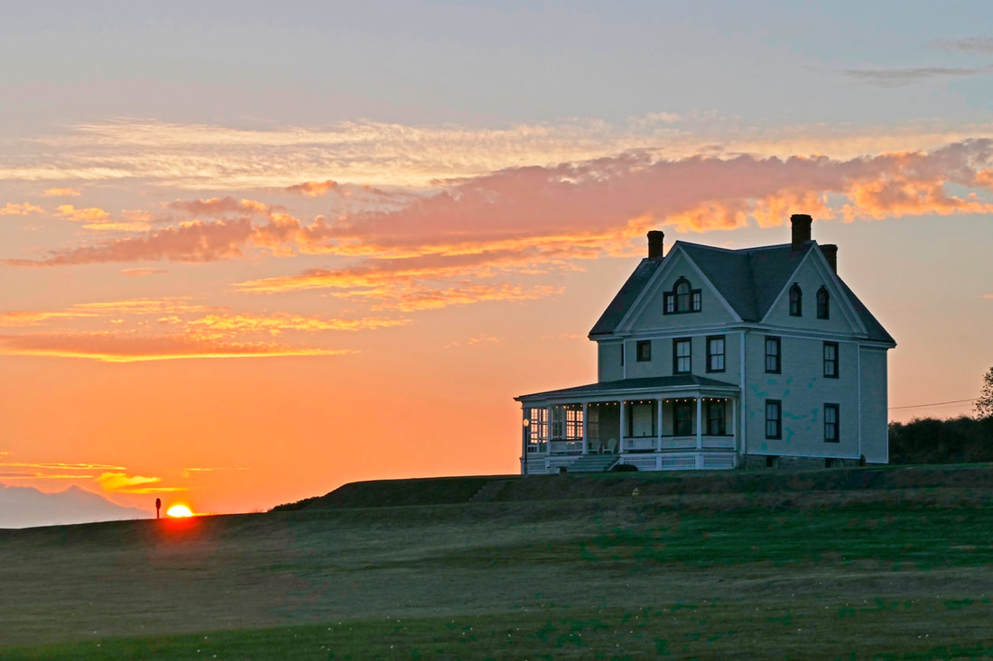 Fort Casey was built at the beginning of the 20th century. The fort continued operations to deter enemies approaching Puget Sound until just after the end of World War 2. While active, the Coast Artillery forces practiced daily, firing their guns at moving targets, getting better with their accuracy, and finding new ways to ensure that the homeland they were protecting was safe from whatever threat the enemy may present. And at the same time, the soldiers lived their lives here. They ate here. They watched sunsets, played ball games, marched in formation, polished brass, mowed grass, and dreamed of home. The enlisted men slept in bunkhouses. Officers stayed in grand mansions, separated from the common soldiers by the green expanse of the parade field between them. But the officers did much the same as the soldiers after work, eating their meals, sitting on their porches with a book, writing letters back home wherever that may be, and also dreaming of being home someday. My father joined the war effort in World War 2, and became a Coast Artillery officer, teaching others how to fire anti-aircraft guns to protect our coastline. As a child I saw the Coast Artillery patches he had worn, the same patches on display here; I handled the brass insignia that had graced his collar and hat; I hefted one of the shells that had somehow ended up residing in the corner of our dining room. And here is where those tokens of a chapter of my father’s life would have been seen every day, handled and touched and used as naturally as the handle on a bunkhouse door, or the rope which secures the flag flying over the field. The federal government surplused the fort property to Washington State in the Fifties, adding it to our amazing collection of state park lands. The area of Camp Casey with bunkhouses and residences of the fort, however, became the property of what was then Seattle Pacific College. Today these buildings lie silent. Deer outnumber visitors. During normal weeks of normal years they are occupied with school groups, soccer camps, church retreats, kite flyers, family reunions, university classes, or whatever else might need a large gathering place in a magnificent setting. But this evening they are empty, perhaps haunted or just lost in thought remembering the days gone by when the fields were busy with soldiers carrying out orders, led by older men giving out orders, everyone here working to protect the rest of us living our normal lives further down the waters of Puget Sound. You don’t really hike Camp Casey. You stroll, you amble and ramble, you walk and talk. You could march and step and parade, or you could saunter and jaunt and stretch or stride. I did most of these wandering around the sidewalks and along the beach, stopping frequently to wonder about military life here back then, and to enjoy what it is like to tour the grounds today. Paint is peeling in places, the walkways untended and rough. But the feeling of a fort remains, the heavy presence of order, and the evidence of the mission to serve and protect the homeland, the cities nearby, and the folks back home. I too lived at a Coast Artillery fort for a decade, at Fort Worden just across Admiralty Inlet, raising a family that lived in one of the officer’s houses. We ate our meals, walked the sidewalks and fields, wandered the beaches and watched life happen. Today the memories of those days are thick and resonant within me, the ghosts of earlier times inhabiting my heart and reminding me of days gone by. The sun lowered over the Olympics as this day ended at Camp Casey. A light fog began to envelop the parade field. The mist of time swirled around me, and lives unseen walked Camp Casey once again. jack Directions: From Highway 20 in Coupeville take Main Street south, which turns into Engle Road, for 3.6 miles to Camp Casey. Park near the office and ask for permission to walk the grounds, or call ahead at 360.678.5050. Camp Casey is accessible by Island Transit. Comments:
Thank you, this is the best description and narrative I’ve read about the camp. It really gave the Fort the human side of such a facility. It wasn’t just a place with bunkers, and 10” disappearing guns. Verleen Boyer |
Authors
Maribeth Crandell has been a hiking guide in the Pacific NW for over 20 years. She's lived on Whidbey and Fidalgo Island for decades. As a frequent bus rider she easily makes connections between trails and transit. Archives by date
July 2024
Categories
All
|
 RSS Feed
