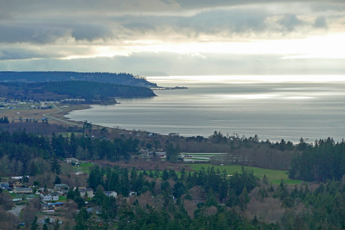
 “When Chekhov saw the long winter, he saw a winter bleak and dark and bereft of hope. Yet we know that winter is just another step in the cycle of life. Standing here among the people of Punxsutawney and basking in the warmth of their hearths and hearts, I couldn't imagine a better fate than a long and lustrous winter.” Phil Conners, Groundhog Day January has been a windy, wet, wild, gray, cold, dark, shadowy, and blustery month. I knew I needed to get out regardless of the weather and dispel the wintertime blues with some adventurous hiking. As I drove west, I could see the clouds thinning out, and even a hint of the sun playing peek-a-boo. I headed to Deception Pass, but not wanting to deal with the crowds of people who will descend there with the slightest break in the weather, I crossed over the bridge and kept driving past the overcrowded bridge parking lot, down to Cornet Bay Road and then east. I parked just west of the Retreat Center exit road, found the entrance to the Bob Marchett trail, and headed toward Goose Rock. Soon I came to the wetland, with a bridge made of half-logs covered with metal grating for good tread. As I crossed, I saw an Indian Plum with bright-green leaves exploding out of its swollen buds, the first greenery of the year. The color was brilliant against the grays all around. Eventually the trail intersected with the connector trail coming from the park office. I followed that east down to the shores of Cornet Bay. A young couple were rowing a boat, lighthearted and laughing as they shared a maritime adventure. A man came down the trail from Goose Rock, dressed only in an orange t-shirt and shorts. As I looked at my clothing of jeans and a long-sleeved shirt and sweatshirt under a jacket, one of us was not dressed appropriately. Then he turned and ran back up the steep trail. Now I fully understood. I headed east on the Perimeter trail, finding two people looking quite perplexed. I asked if they would like some directions, and they said yes, could they get to the bridge by going the way I had come from? I said yes, but there would be a couple key intersections they would need to negotiate to get back to the bridge. They took the safe choice and headed back the way they had come. Meanwhile, I passed a currant with the tiniest tips of green as their new leaves tested the winter air. They will be flowering pink very soon. Offshore, two people paddled a bright blue kayak across the evergreen waters near Strawberry Island. The Perimeter Trail leads to the NE Summit Trail, a seldom-used route that climbs steeply and steadily. I followed that to avoid the far more popular NW Summit trail. As I climbed, sweat began to soak my first layer of clothing and drip off my hair, so I took a break and had a piece of raspberry chocolate, a much-appreciated gift from a friend. As I munched, I noticed a huckleberry also leafing out here in the dense shade of the backside of Goose Rock. Winter was losing its grip. I hiked up to the top and wandered over to the northwest peak of Goose Rock; of the two peaks it has the most expansive views. Sunlight reflected off the Salish Sea near the westward-facing points of Whidbey Island; bright clouds over the Olympics framed the peaks and foothills in bold splashes of light. I noticed the low cedar railing that defines the trail around the fragile meadows on Goose Rock were in a state of disarray. The signs that said “Please respect the meadow” were faded to the point of being illegible. A group of hikers arrived at the top and promptly stepped right over the railing, not understanding their purpose and value in protecting the meadows. Having now cooled off from the ascent, I took the South Summit Trail back down, with two runners wearing yellow camelbaks passing me as they ran up the hill. I entered the wild garden of rhododendrons and observed that the rhodies were still tightly wrapped up in their winter wear, waiting for warmer and longer days before budding and flowering. Then I heard a tonk-tonk-tonk. Tonk-tonk-tonk! I looked around for a bright red head, and soon found one on the side of a large Doug fir that looked healthy except for the growing holes in its bark from the pileated woodpecker drilling for dinner. Soon I was almost back to Cornet Bay Road. During the last hundred feet I saw a flash of pink off to the side. A salmonberry flower had emerged in full glory to celebrate a new season, shouting “It’s spring!” Maybe the calendar would disagree, but my winter-weary spirit welcomed the message. jack Directions: You can get to Cornet Bay Road for free by transit bus from the March Point transfer point or from anywhere on Whidbey Island. Or you can park at the bridge, if there is room, or south of the bridge on the south-bound side so long as you are fully off the roadway. Or you can park at the park office, at the nearby store, or at the large parking lot at east Cranberry Lake. Or you can park like I did on the side of the road on Cornet Bay Road, just west of the retreat center, and follow the Bob Marchett trail towards the peak. Again, be off the traveled portion of the roadway and make sure the shoulder is level and solid where you park. A good map of the trails is recommended if you are not familiar with Goose Rock.
0 Comments
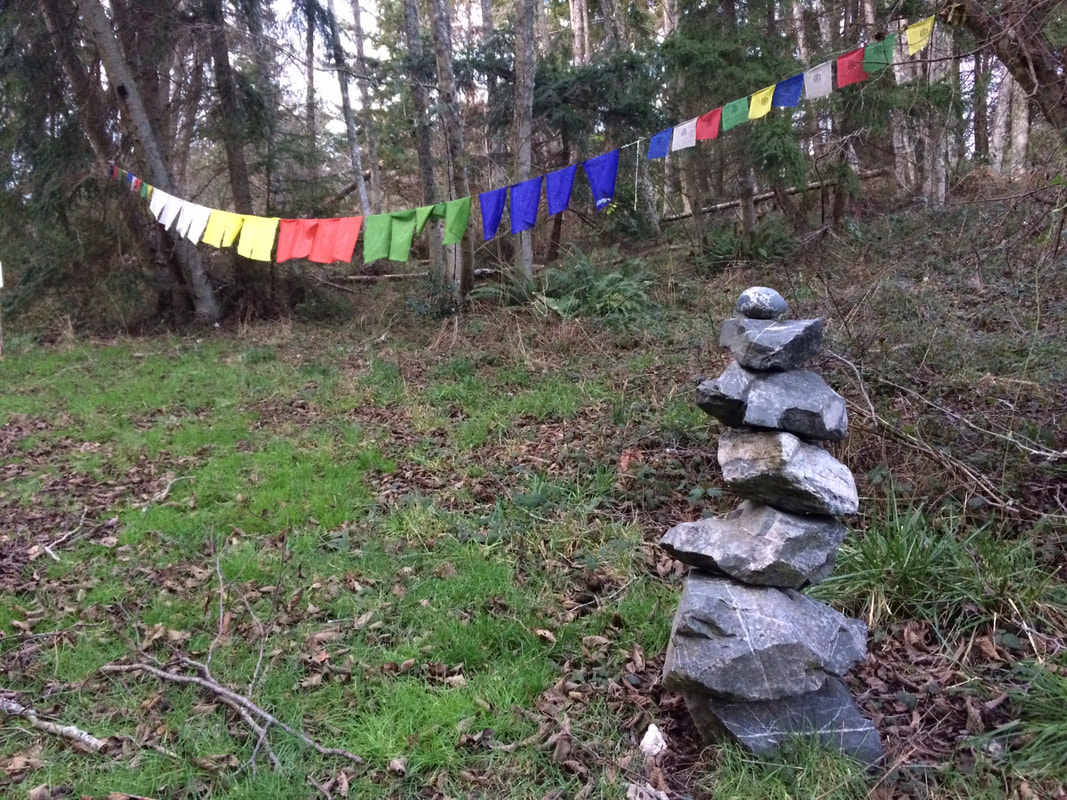 I have a hard time planning a week ahead, but the Earth Sanctuary has a 500 year plan. When I took a walk there last weekend I felt like I was connecting with something ancient. It could be the large stone dolmen, or the labyrinth, the colorful prayer flags or prayer wheels that spin prayers out into the universe. After traveling and encountering such things in the British Isles and in the Himalayas, these features are familiar though rare here. The Earth Sanctuary is owned by Chuck Pettis, visionary, designer, land artist and author of the book, Secrets of Sacred Space: Discover and Create Places of Power. Pettis was recognized in the September 2008 issue of Science of Mind magazine as someone making a difference in the world. He vows to restore this 72 acres to mature old growth forest actively working to increase the biodiversity of plants, animals and fungi. Besides the man-made features, there are standing snags that provide habitat for a variety of wildlife, the nurse logs that hold moisture for native plant nurseries, and a huge glacial erratic sitting among the trees. Wood duck boxes and other habitat enhancements make this a wonderful place for bird life. The ponds and wetlands provide a great place for waterfowl, and the upland forest offer homes to song birds, woodpeckers and raptors. On my walk in the late afternoon, I heard tree frogs, a hairy woodpecker, flickers, crows, red winged blackbirds and an eagle. With binoculars I watched ring-necked ducks and the white flags of hooded mergansers swimming across the pond. The golden crowned kinglets, bush tits, pacific wren and sparrows were up close and personal in the brush by the trail. When I met other bird watchers we compared notes. It’s a good place to sit quietly and wait for the wildlife to come to you. Benches are positioned with a good view of the water. One chair next to a small stream offered a place to sit and listen to the soft cadence of moving water. Cairns of every shape and size appear along the way. As the afternoon leaned into evening, I came upon a tall circle of standing stones harking back to Stonehenge, a place of solemn stillness. Quiet, sacred places have been created throughout the forest. I offered my prayers, spun the prayer wheel and made my way back along the trail thinking “What is 500 years to a cedar or a stone?” Please leave your dog at home, but bring your binoculars. For more information visit: earthsanctuary.org/ Mb Directions:
The Earth Sanctuary is 1 mile south of uptown Freeland on Newman Road. Or if you're coming north from Bayview on Highway 525, turn right on Newman Road and drive about 1 mile until you see the sign for the Earth Sanctuary. It's directly across from Island Art Glass on a narrow dirt driveway. There is a $7 fee for entering this privately owned forest sanctuary. 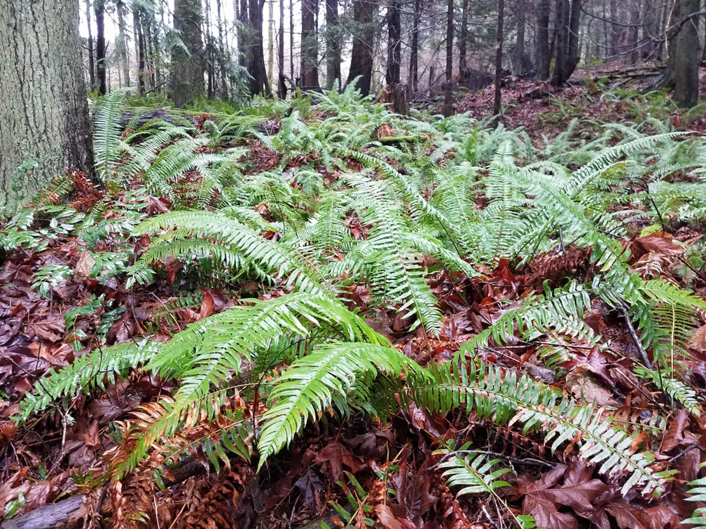 "Most men pursue pleasure with such breathless haste that they hurry past it." - Soren Kierkegaard It was my fault. I was in a hurry. I had a little over an hour before an appointment in Anacortes, so I chose to hike around Little Cranberry Lake. I figured I could do that and still have a minute to spare, maybe even two. Besides, stormy snowy weather was coming. This might be my last chance for a forest hike for a while. It seemed odd to me that the parking lot on A Avenue was nearly empty on a late Saturday morning. But it was only 40 degrees and the rain had been relentless until just now. Maybe other people have more sense. I hiked north on trail 108, enjoying the quiet, the greenery, the trail meandering among cedars and firs and past the 32nd Street Swamp (this wetland needs a better name). I stopped to listen to Big Beaver Pond spilling over beaver dams into the swamp, took a minute to take a picture and video of the falling water, then realized again my time was limited and I proceeded on. But maybe I also realized that today didn’t have to go according to plan. I digressed down trail 123 to follow the shoreline of that pond. Across Big Beaver I could see a lone swan preening itself. Buffleheads dabbled nearby. The trail looked like a root farm in places, and a mud farm in places. Recent storms had dropped an alder across the trail. Park ranger Steve Phillips had already removed it. Dropping down to Little Cranberry, I turned left to go clockwise around the lake, starting on trail 132. I looked up trail 106 and saw a familiar face – Bob Jepperson. He called my name and I strolled over, greeting him with a joyous smile. If you don’t know Bob, spend any amount of time in the Little Cranberry area and you will probably run into him, armed with a camera and a deep understanding of what is here. He devotes much of his time and energy to knowing these woods, the life in the woods, the critters that call it home, and how their homes and lives grow and change through the seasons. Bob shared some of his observations about the lake levels, the impact of trails on turtle health, and the possible impact of the coming winter storm on the mating habits of red-legged frogs. As we talked, I had a clock running in the back of my mind about my desire to get all the way around the lake before noon. But in my heart, I knew that hearing these stories of real life from Bob was a far better experience. In the middle of our conversation, I heard five sounds from the edge of the water nearby. I can only describe them as quacks, in quick succession, but very subtle and subdued. We both listened. It sounded like oh- oh- oh- oh- oh, taking about 2 or 3 seconds; pausing a few seconds, then repeating. “There’s your red-legged frog,” Bob said quietly. It was probably underwater, advertising for a mate. We neither heard nor saw any responding female. My interest in hiking morphed into a far deeper interest in the life right at my feet and all around me, as my eyes and ears opened to the wonders of the woods. I eventually thanked him for the time together, and strolled along the east shore of Little Cranberry, listening to a kingfisher clack across the lake, seeing the vegetation returning in the burn area, detouring to the bat cave, climbing trail 103 to the top of the burn area, now listening to soprano Pacific wrens, and other birds in a tenor range. A slight rain shower floated through, and then I was back on trail 108 heading back to the car, slower and more deliberate in my steps, attuned slightly better to the magic, the mysteries, and the life that shares this planet with us, in its own pace and time. jack https://www.bobjepperson.com/ Bob has a delightful book out called Wild Love Story, and a new book of stories coming out soon. https://www.bobjepperson.com/soundlink for the sounds of the red-legged frog. A wild love story you can listen to. Directions: From A Avenue near 37th in Anacortes, park near the kiosk and walk in. I turned right on trail 108 to head to Little Cranberry Lake. From D Avenue, go to the west end of 29th. From Oakes Avenue, come up Georgia Avenue and turn right on Cranberry Lake Road to drive to the parking lot at the north end of the lake.
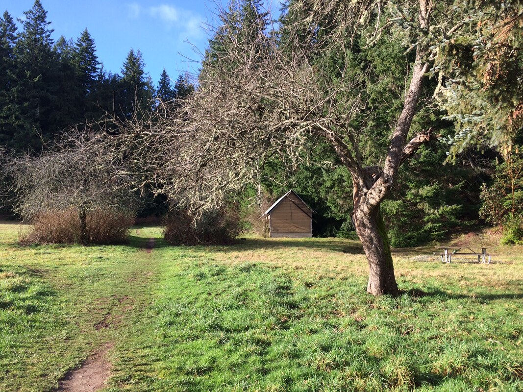 After wind, rain, and winter storms, last Saturday beamed like a beacon drawing me outside. When I arrived at the 120 acre Saratoga Woods there were no cars in the parking lot… which lasted about half a minute. Cars pulled in on both sides of me. A couple opened the back, put their dog on a leash and started for the trail. Another couple did the same. They started up the Indian Plum and Meadow Loop Trails, while I investigated a field of young, blue collard trees and shrubs just outside the entrance. They’re part of a wetland restoration project. I admired the little sprouts and wished them good growth in the New Year. Then I discovered an active ant hill conveniently located near a picnic table. They were bustling about in the sun. No one had told them it was January. Finally I entered the forest and began my climb up the Wintergreen Trail between tall cedar, fir and alder trees toward the top of the forest. I employed my kick-a-stick-a-day trail maintenance techniques as I walked. One tree had split and fallen across the trail but was easy to step over. This forest is magical with deep shade and serpentine trees that seem to be in a very slow motion dance with each other. Many look like shape shifters that might take a different form as soon as you turn your back. In places the trail narrows with tall hedges of salal and evergreen huckleberry towering over my head. There were bright, glowing fungi and dark, damp slugs. Kinglets sang from the crown and Pacific Wren were busy in the brush. One trail named Spring Board Alley reminded me of Harry Potter and one huge, mossy stump brought to mind his friend, Hagrid. I made my way up until I emerged out of the dark, mysterious forest into the bold light of day on a long, flat, wide stretch of trail which was once an airplane runway. Trees and shrubs have crept in along the sides but it still has an unnatural feel to it. I turned north and followed the ridge, or drumlin, a geological term from an Irish word (droimnin) meaning little ridge, molded by past glacial action. I began to meet other hikers, joggers, dog walkers, horseback riders and mountain bikers as I neared the main attraction, the Waterman Erratic. There is no sign, except a well beaten path that dips off the ridge to the west. I parted some branches as I came upon the huge rock, thirty-eight feet high and sixty feet long, left by the glacier as it melted thousands of years ago. Scientists believe this rock was transported by the ice (or magic spells) all the way from Orcas Island. A friend told me he brought his grandson here to see the rock that’s as big as a house. The boy circled the stone and asked, “Where is the door?” People come from near and far to see this enormous rock. On this particular day I met visitors from Hawaii, Kansas City, California, North Carolina and others from the local neighborhood. We reached out to touch the moss and ferns growing right on the rock lit by a heavenly glow. I left the rock encircled by many hands. On my way down the hill, shadows closed in on the Bent Tree Trail, a breeze stirred the branches, and I could sense the wizardry of the forest. Directions:
From Highway 525, turn north on Bayview Road toward Langley. As you enter town turn left at Saint Hubert's Catholic Church and left again on to Saratoga Road. Drive another 2.5 miles. The entrance and trailhead is on the left. For a trail map visit: www.islandcountywa.gov/PublicWorks/Parks/Pages/saratoga-woods.aspx |
Authors
Maribeth Crandell has been a hiking guide in the Pacific NW for over 20 years. She's lived on Whidbey and Fidalgo Island for decades. As a frequent bus rider she easily makes connections between trails and transit. Archives by date
July 2024
Categories
All
|
 RSS Feed
