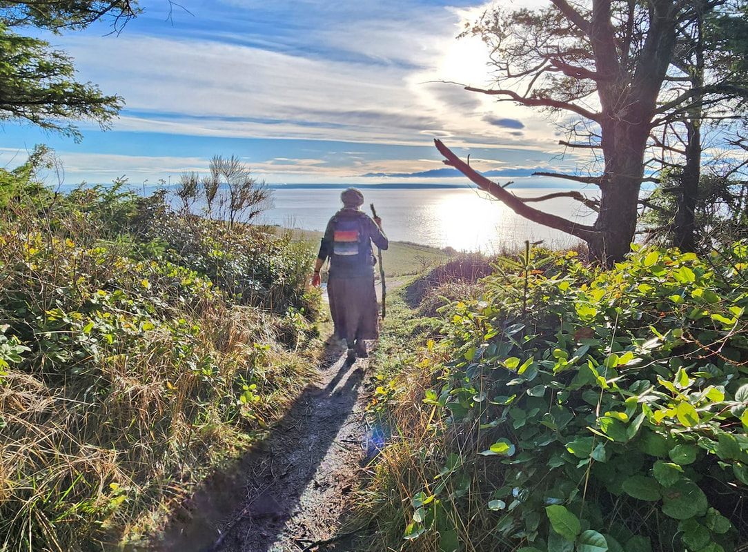
 “A good hike starts with a stop at Starbucks,” Kath said. Me, I prefer a water bottle in my pack, along with a Kind bar, or any other dark chocolate bar, or any chocolate whatsoever, be it a truffle or KitKat or chocolate-covered almonds or even Aunt Martha’s chocolate fruit cake, anything chocolate. But I digress, and now I’m salivating a little. After a week of extreme cold and a couple inches of snow which became compact ice, and with the coming week predicted to be warm but drenchingly wet, this past Saturday bloomed with unexpected sunshine, warmth, and clearing skies. Our goal was to hike the Bluff Trail at Fort Ebey State Park to be rewarded with the view at the big meadow, a place Kath had never been to before. So, after stopping at Starbucks, we drove out to the west end of Libby Road, walked onto the beach as the tide began to recede, and headed south toward the park. Kath finished her green matcha tea as we hiked. The Olympics bared themselves beyond a pancake-flat Strait of Juan de Fuca. After walking a half mile on the beach, we found the path leading into the state park. Climbing up the bluff trail, still frozen and slippery in places, a side trail took us directly above Point Partridge; from here we could see Japan if the earth were flat. And we could see our destination ahead, the big meadows of Fort Ebey, sunny green and inviting. Next we entered the hidden bunker that looks out over the strait. The sun’s heat rolled up the grassy bluff and melted the coats right off of us. We climbed and descended the shadowed icy trail, then up the next ridge, Kath’s broken-branch walking stick giving her traction where my big feet gave me skis. Shafts of delicious sunlight drifted down through fog, and lichen hung like tinsel in the trees. The welcome warmth, the still air, the smells of spruce and thawing soil, the twinkling voices of kinglets, and the incredible views made us feel we had entered springtime out of a frozen Narnia. And then we were there. A stalwart fir tree created a window welcoming us to the huge meadow below our feet. If you haven’t hiked this trail before, then imagine that tingling feeling of seeing the first signs of spring as the meadow leads your eyes to the waters, to the mountains, to the sunshine, to the feeling that you have been here before, to the feeling of being home. The Bluff Trail magic had worked. We wandered the meadow like school children, dancing and singing, freewheeling on this January day that felt like June. The trail circled to the gun battery, a dark and stark reminder of the fearful history that has become this transformed stage of peace. After a potty break, we returned down the trail, skipping across the snow as it continued to melt, then taking the short walk to a frozen but restful Lake Pondilla as our icing on the cake. That reminded me: I enjoyed my chocolate bar and a drink of water as we walked back along the beach in the slanting golden sunlight of the early evening. jack Directions: From Highway 20, four mile north of Coupeville, turn west onto Libbey Road. We went to the parking area at the end of the road, but you can also turn left on Hill Valley Drive which leads directly into the park.
By bus: Route 6 Southbound comes to about a half mile from the Libbey beach access. By bike: West Beach Road is a quiet but hilly access route from the north. The Kettles - Rhododendron bike trail leads north from Coupeville to the Kettles which has trails leading directly into Fort Ebey. Mobility: Within the park there are accessible overlooks near the meadow; otherwise the trails are a mixed variety of hilly, with dirt, gravel, and when we were there, ice as a base to walk on.
0 Comments
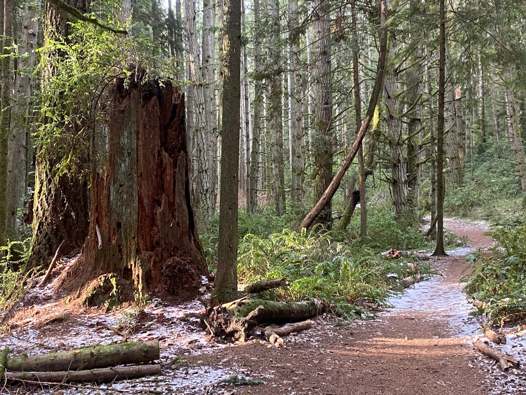 The most hazardous part of going hiking is often driving to the trailhead. That was certainly true this week when snow on South Whidbey was packed hard and frozen creating a layer of almost invisible ice on the roads. Most people stayed home, but as the highway and main corridors were scraped and sanded, traffic began to flow again. Still the shady back roads had treacherous curves waiting for an inexperienced driver with more speed than good sense. Lee drove carefully to Saratoga Woods without slip sliding away. We pulled into the parking lot with just one other car, and another dog that needed a walk. Lee and her dog, Piper, were suffering from cabin fever. After being cooped up inside with this freezing weather we all needed a walk. Another truck pulled in just after us. A man got out followed by an eager chocolate lab. Drat, he said, his tool box on the back was frozen shut. He asked if we had a tennis ball. Lee found one in her trunk and tossed it to him. Piper had found it somewhere, she said, he could keep it. He swung his chucker and the dog launched after it in hot pursuit. We started our walk in our all-terrain-vehicles (snow boots) passing an old apple tree that was nearly hollow and riddled with sapsucker holes and still alive. An apple was stuck between its branches. This used to be a homestead. The remains of a building had been made into a picnic shelter. Across the road was the water and Mount Baker shining on the horizon. Though there was snow on the ground, the sky was clear, blue and bright as we took the trail across the field. Just passed the trail signs we plunged into darkness, entering a castle of tall trees. Piper led us as our eyes adjusted. A huge stump stood guard near the entrance, adorned with oranges, candles and long strings of red cranberries. We walked on, veered left, climbed a hill and circled back, soon finding ourselves at the meadow again. We laughed and started over. Staying on the straight and narrow we gradually climbed the ridge through the woods to the old runway, flat and straight, north and south. We crossed it and took another trail that led us to a fence and a No Trespassing sign. We laughed and turned around. Before reaching the runway, we turned left again following a narrow trail that paralleled the main drag. In a few minutes we arrived at our destination, the Rock. This house high boulder had traveled far on a cushion of ice that melted ten thousand years ago (give or take) to land here. The woods had grown up around it. Now it felt like a hidden treasure to be discovered by wayward wanderers. The rain, from the week before, had been absorbed by the moss on top and then trickled down the sides as temperatures fell, becoming an arsenal of icicles. A crystal waterfall edged down one side sparkling in the mid-morning sun. We circled the monolith standing back and peering up. Tall trees peered down on us from above. We climbed back up to the snowy runway, crossed it and headed down the Bent Tree Trail. Aptly named, this trail led us to curiously shaped trees that told interesting stories. One serpentine cedar crawled along the ground for 15 or 20 feet before swerving skyward. Another coiled itself at the base before becoming vertical. Another offered itself as a convenient seat alongside the trail. I couldn’t resist. Our descent brought us to another trail intersection and another decision to make. We discussed our options and then made our choice. Soon it became apparent which way to go. We emerged from the woodland castle refreshed by a wonderful walk to an enchanted stone, through a forest of magical trees. Maribeth Saratoga Woods has miles of trails that connect to Putney Woods and Metcalf Woods so it is easy to get turned around and walk much farther than intended. If you'd like a map, try this one. Directions: From Highway 525 in Bayview take Bayview Road north 3.6 miles to Langley. Turn left just after Saint Huberts Church on De Bruyen Ave. In one block turn left onto Saratoga Road and drive 2.5 miles to the parking lot on the left.
By Bus and Bike: Currently the closest bus service is to Langley at Anthes and 3rd, 2.8 miles from the trailhead. Saratoga Road is steep and windy with no shoulder. If you chose to ride a bike with traffic, please wear bright clothes and use lights. Mobility: This trail starts wide and gentle but gets steeper, and narrower, with more roots as it climbs to the runway. Though the runway is wide and flat, many of the trails are very narrow.  Storms. They power into our lives with their force and fury, rattling our windows and walls, drumming on our roofs, and freezing our fingers and faces. We sit inside, thankful we are not outside getting drenched, blown, or frozen, or all the above at the same time. Yet we face storms daily, putting on a smile while within us though we are cold and hurting, blown by the winds of circumstances, drenched by downpours, and frozen in finding a way forward. In the past year Kath and I celebrated a honeymoon and our first anniversary; we enjoyed family adventures, travels to several states, and gardening on our lanai. And we had health issues, family issues, and financial issues. The year was packed full, and over so soon. Your stories and mileage will vary, but I bet they are similar. Sometimes it feels overwhelming, yet we must keep moving and doing. We come to the end of the day exhausted, scrambling to keep up. There’s good, there’s bad, there’s boredom and excitement. There is a storm of material circling in our heads and hearts. And sometimes, yes sometimes, we can find a match for how we feel by stepping into another storm not of our own making, finding solace and comfort in knowing we are not alone. This is a shared experience with all of life – the old and the young, cedars and seagulls, salmon and salamanders, finding food to survive, moving to the rhythm of changing conditions, wet or dry, hot or cold, stormy or calm. A storm was brewing this day, threatening. Southerly winds roared across Whidbey and Fidalgo. Rainclouds buried the Olympics and began billowing our way. We headed outdoors, to the northern shore of Whidbey. We walked down the hill from the bridge, the wind howling through the treetops, the seas heaving and sighing as they passed. Branches danced and sometimes fell. Currents raced out the pass, eddies swept the other way. I immediately felt refreshed and renewed from the wild scene. The storm matched something inexpressible and gave affirmation to me as a human that I am not alone in this world as I contend with the unpredictability of everyday life. With the tide high but falling, we chose to scramble along the trail above North Beach as we walked west, then hoped the waters would lower enough to walk the beach all the way back. We passed giant firs standing above the seashore, their tops in the wind, but all was calm where we stood below. For a half mile, slippery roots and rocks, ups and downs and twists and turns kept us alert as we walked the trail above the beach to the amphitheater. Needing a restroom, we walked hastily into the full force of the wind down the nearly empty West Beach parking area to find one. Walking back north along West Beach, large waves washed over the sand and cobbles. Rainclouds were closer now, the wind strong at our back. People passed by with their coats zipped high, hats down low. We scrambled across West Point and onto North Beach, back out of the wind again. The tide still wasn’t low enough to get around the first low headlands, but easy trails let us climb around them. There were no footprints on the beach beyond these, so we made our own. The headlands in the middle were now above the tideline. We strolled down to Little North Beach to stand nearly beneath the bridge, and then ascended the trail back toward the parking area at the top of the bridge. Pausing near the top, we looked back over North Beach, rain now coming down in buckets. Our spirits felt cleansed and renewed; we sang and harmonized together, embracing whatever the new year will bring. jack Note: We found that we could walk the beach around the large headlands in the middle of North Beach at a tide of about 5 feet. The headlands between there and West Point would have to be at least a foot lower to get around them. But there are trails on both sides to get over them.
Directions: The North Beach road is closed, so park either at the bridge parking lot and walk down, or at West Beach inside the park. A valid parking permit is required at either location. By bus: Island Transit stops at the park entrance near Cornet Bay Road. By bike: Highway 20 has narrow shoulders, long hills, and heavy traffic. Mobility: The North Beach trail is narrow and filled with roots, rocks, ups and downs, but was not muddy. The beach is a mixture of sand and cobble, with wide graveled trails from North Beach parking area available when North Beach road is open during the busy use season. 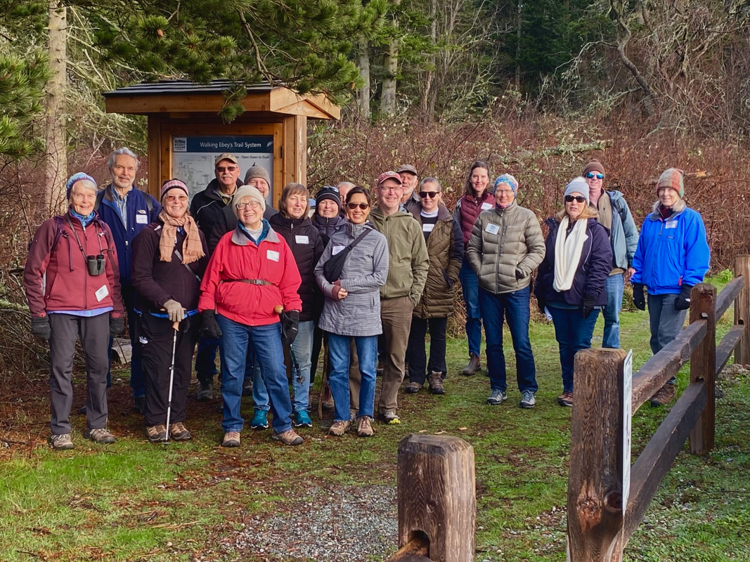 First day hikes started in Massachusetts in 1992. By 2012 they were held in all 50 States, typically in State Parks, but not exclusively. On Whidbey this year, there was a bike ride led by a ranger at Fort Ebey State Park, an historic tour at Fort Casey State Park, a walk for families with kids at South Whidbey State Park, and at Deception Pass State Park there was a scavenger hunt at Bowman Bay (north of the bridge on Fidalgo Island). In addition, there was a guided walk at Meerkerk Gardens, and the Whidbey Camano Land Trust offered a hike on the Walking Ebey Trail in Coupeville. That’s where I was on New Year’s Day along with a group of about twenty others. The skies were clearing as we gathered across the road from the Admiralty Inlet Preserve. The Olympics were just peeking through between layers of clouds. Everyone seemed in a good mood, ready to start the New Year with a good walk, exploring a new trail, with a fun group and an experienced guide. Janet Hall took the lead as a Land Trust board member. Vin Sherman came along as the local historian and celebrity storyteller. Born and raised on Ebey’s Prairie, he added cultural context with colorful tales of the farmers and homesteaders. Janet stopped to point out where pines had been planted too close together. The Land Trust had thinned them which allowed more sun and underbrush. Plant diversity invites animal diversity. We heard the cheerful twittering of small birds as we passed through. The Land Trust owns the first little bit of the trail, but most of it follows easements, along hedgerows, between fields and pastures. “This is mostly private property,” Janet reminds us. “The owners can take access away at any time. So please be respectful. Pick up after your pet. Don’t disturb the livestock. And please stay on the trail.” We noted the signage at every turn. Some were small brown posts with a Walking Ebey logo on top. Others had a map and a You Are Here pinned to it. If you were tempted to take a wrong turn, you’d most likely see a No Trespassing sign. There were signs warning of electric fencing. At one point Janet said the cows had become so curious about the hikers, they’d knocked the fence down. An electric fence replaced it. Short sections of the trail were open to equestrians or cyclists, and others were not. It was a bit of a hodge-podge. Walkers and dogs on a leash are welcome the length of the trail. The idea of walking the property lines reminds me of walking in Great Britain where they allow people to cross their fields as long as they close the gates behind them. It’s common in other parts of the world, too, but sadly, not in America. We're a car dependent nation. We hike for recreation, not to get from one place to another. Personally, I prefer walking. It’s good for me and the planet, and walking between farms and fields with no traffic is a delight. The Whidbey Camano Land Trust plans to connect the trails across central Whidbey so you could walk from the ferry to Admiralty Inlet Preserve and up to Ebey’s Bluff and the Pratt Loop to downtown Coupeville and over to the Price Sculpture Park. The Walking Ebey trail is a 3.5 mile corridor connecting the Admiralty Inlet Preserve with Rhododendron County Park. Our group went chatting as we crossed fields, ducked between hedgerows, followed farm roads, passing barns, farms, goats, horses, cows, spying a raptor here, a songbird there, with distant views of the water and mountains. Nearing the end we entered the woods at Rhododendron Park. Vin told us how they used to cut rhody blossoms to decorate the school for prom night. The Walking Ebey Trail connects the farms and the forest, the west side with the east, the past with the future. Starting the New Year with a walk is a step in the right direction. Maribeth Find a trail map here This is a one way trail. If you need a ride back to the other end call 360-678-7771 at least 2 hours ahead to arrange for on-demand bus service with Island Transit. The closest bus stop to the north end is Quail Trail Lane or Jacobs Road on Hwy 20 near the entrance to Rhododendron Park. On the south end of the trail the bus can stop at the Admiralty Inlet Preserve parking area on Engle Road, but drivers may need you to point it out to them. Island Transit buses are fare free and offer daily service except on holidays.
Directions: From the stop light in Coupeville take Main Street south toward the ferry (which turns into Engle Road) for 2.5 miles. Parking is on the left at the trailhead for Walking Ebey or the Admiralty Inlet Preserve across the road. Or to start at the other end, take Highway 20, 3.5 miles east of the light in Coupeville and turn right on Patmore Road. In a half mile you can park at a gate on the curve on the south side of Rhododendron Park. Please don’t block the gate. Walk through the gate on the Rhodie Road to find the Walking Ebey Trail on the left. Bike and Bus: Island Transit has on-demand service to the Admiralty Inlet Preserve and Walking Ebey parking lot. Call at least 2 hours ahead to arrange a ride. You will need to meet the bus at a bus stop. Route 1 will take you to Coupeville where you can meet the on-demand bus. Or catch the Route 1 bus to Rhododendron Park. The nearest bus stop is at Quail Trail Lane or Jacobs Road, a short walk to Rhododendron Park. The Walking Ebey Trail starts at the south end of the park and heads west. Biking to the Admiralty Inlet end of the trail is easy from downtown Coupeville or the ferry. There are wide shoulders and beautiful views. Please wear something bright and use lights when riding with traffic. Mobility: This trail has a few rough spots and wet areas but is fairly level. One short section climbs a hill and goes through a Fat Mans Squeeze so not accessible for wheelchairs or walkers. A shorter alternative (1.5 miles) goes from the Admiralty Inlet trailhead to the Prairie Wayside Overlook on Engle Road which also has parking. (Visit the website for details. ) |
Authors
Maribeth Crandell has been a hiking guide in the Pacific NW for over 20 years. She's lived on Whidbey and Fidalgo Island for decades. As a frequent bus rider she easily makes connections between trails and transit. Archives by date
July 2024
Categories
All
|
 RSS Feed
