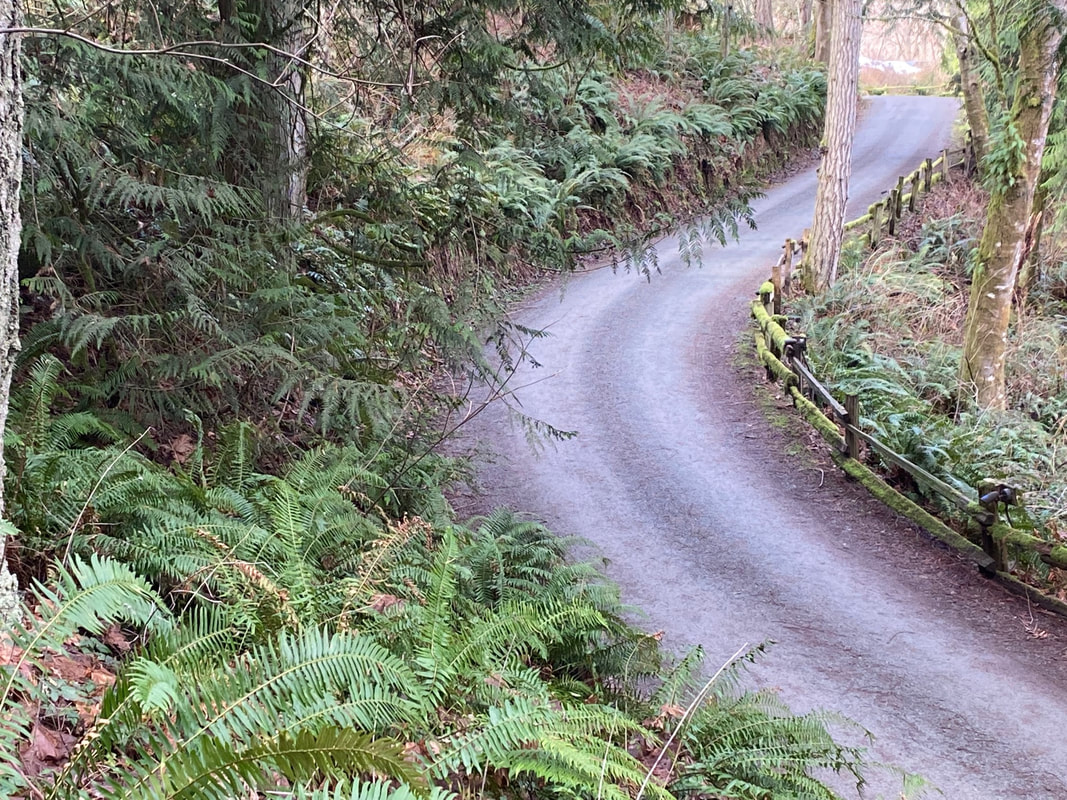
 As I walked the old Farm Loop trail I noticed how it had narrowed since we built it back in the 1980’s. It was once an old road where you could walk side by side with a friend. Now it seemed little wider than a deer trail. The forest closes in. Trees fall in storms and open the canopy to light. New growth begins. There was a variety of trees, alder, cedar, Doug fir, grand fir, maple, even yew. And the birds! Flickers, chickadees, song sparrows, nuthatches, towhees and pine siskins flying among the tree tops. Water trickled nearby in a constant song of its own. A woodpecker drummed on a tall snag, but which one? The forest was crowded with dead wood still standing and on the ground, providing homes, offering nutrients, turning slowly into soil. Wet ferns were steaming in the morning sun. I emerged from the forest into a meadow framed by small cabins and followed the road toward the farmhouse. A Finnish family built the log sauna first and lived there while they built the farmhouse well over a century ago. They cleared and farmed the land. Remnants of those times remain in some outbuildings where tools and livestock were kept, but the only thing constant is change. That chapter came to an end and the next one began with Fritz and Vivienne Hull who bought the property in the 1970’s. Envisioning a learning center they attracted a community of young people who helped restore the farmhouse and construct new buildings, bring more people and programs, develop gardens and trails. I was among them back in the day. The Whidbey Institute has a new staff now who manage the programs and care for the land. I passed the cabin where I once lived. Though I saw a few people walking about, it was calm and quiet which left plenty of room for my reminiscences. I passed the farmhouse and Thomas Berry Hall and dipped into the forest again crossing a bridge on the trail to Granny’s, a guest house a short walk away. I helped build this trail, too. Climbing through the woods I arrived at Granny’s which used to have a view of the Olympics, but now, was closed in by trees. I rested in a chair on the deck, had a snack and indulged in recollections. “Time to move on,” I thought, and launched into unfamiliar territory on trails I’d never tread. I climbed over the hill toward the Waldorf School, took a turn down the road and came to a sign pointing to the Story House and Legacy Forest. On my way up the road, I was met by a golf cart. Timothy recognized me and stopped to give me a hug. He’d grown up here and I’d known him since he was a boy. It was like time travel to see him there again, still. He buzzed off in his little cart and I continued my walk. The map on the kiosk was very helpful and I took a photo with my phone. I took the Upper Loop trail, passing a glacial erratic about the size of a reclining elephant. On I went through avenues of evergreen huckleberry and tall trees. The trail descended farther than I would have liked and then climbed again to make the loop. It got my heart pumping. At the South Junction I made a turn toward the Story House and its open clearing. I sat outside on a bench taking in the quiet, listening for birds, sipping water, before heading back to the present and my car parked down on Memory Lane. Maribeth The Whidbey Institute has about 4 miles of trails on over 100 acres of privately owned land. The public is welcome to use the trails during the day but please don’t disturb the buildings or programs and leave your dog at home. For a map click here Directions: From Hwy 525 at Ken's Korner (3 miles from the Clinton Ferry) turn south onto Cultus Bay Road. In 3/4 of a mile turn right on to Campbell Road. Just over the hill turn left on Old Pietila Road. Park at the bottom of the hill. A trailhead and kiosk are in the SW corner of the lower parking lot.
By Bike or Bus: The nearest bus stop is at Hwy 525 and Cultus Bay Road over a mile away. These are hilly roads with moderate traffic on Cultus Bay Road. Please wear bright clothes and use lights when riding a bike on the road. Mobility: The Farm Loop trail is fairly level but narrow and there are some roots and dips. The other trails are more hilly.
0 Comments
 Last Saturday I gave a presentation at Sound Waters University about tides, how to understand them and live alongside them in the Salish Sea. Maribeth Crandell met us afterwards for lunch at Callen's – the salmon BLT is superb, by the way. With full bellies in need of a hike we drove to Long Point east of Coupeville. Picture a classic February beach scene on Penn Cove: gray clouds above a gray beach along flat gray waters – not even wavelets on the beach, just gentle lapping. You could almost watch the tide receding from the shoreline; little else moved. Oystercatchers hung out with gulls on the tip of Long Point. A seal photobombed some goldeneyes paddling nearby. A raft of scoters swam together just offshore, then dove underwater one by one, reemerged one by one, then spooked one by one and flew a hundred yards away. To the east, the empty waters of Saratoga Passage mirrored the pale gray watercolor of clouds hanging like a formless diffuse wash. To the West, Penn Cove disappeared into the distance, the Wharf building the only object protruding into the grayness. We walked the beach, throwing a ball for Murphy who raced after it like a terrier until he eventually tired of the game and just walked the beach alongside us. Conversation flowed between Kath and Maribeth; I wandered in and out of the conversation and along the tideline with the shells and shorecrabs, lost in a reverie of timelessness. 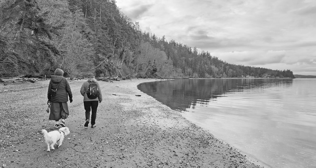 When I was a child, my brother and I would wander down to North Beach from our house near Ballard. We'd play at the water's edge, absorbing the spirit of the Salish Sea, its gray skies, its gray water, its endless lapping of waves. The haunting calls of grebes and gulls became ingrained in our memories as our version of a lullaby. We came to know the flow of the sea, the rise and fall of the tides, the vastness of the waters; Whidbey and the Olympics lay sharply etched beyond us on sunny days and hidden from all but our imaginations when clouds hung low and gray. We knew they were still there; their spirit hung with us as our little legs wandered the shoreline, alone with the elements, becoming a part of them and they a part of us. Years later we would come back here to find crabs on still winter nights at low tide or catch salmon from our wooden skiff on the open water. I would have my first kiss here late one evening as a gentle rain fell on the beach. Walking west from Long Point this Saturday, I sensed the same elements playing in my mind, calling through the years. The decades melted into eternity as my wife and my good friend and co-author wandered along together sharing stories. Gulls hunted the shoreline for shellfish; a grebe dove offshore. Beach cabins blended with driftwood, wood smoke drifting among them. A burial ground of native peoples is here somewhere near the point, its exact location lost through the decades, but the ancestral spirits still at home. I could hear echoes of tribal children walking these same beaches alongside us, the children growing into women who gathered shellfish along the shoreline, and men who paddled the calm waters finding salmon and sustenance, smoke from their longhouse fires drifting along the beach and melting into the firs on the hill above. If you squint, you can almost see them in the background in the photos of our hike together this week. Halfway to Coupeville, the beach is almost totally blocked by fallen trees from the slumped-over hillside. We turned around and headed back to our car parked at Long Point. Murphy didn’t want to get back in the car. I felt the same way. The waterfowl, the gulls and the grebe, the seal and the spirits remained there in the gray. jack Directions: From the stoplight on Highway 20 in Coupeville, drive 2.7 miles south and turn left onto Morris Road. Take a quick left onto Parker Road, drive 1.3 miles and turn right on Portal Place. Drive a short distance to Marine Drive and turn left; follow it to the end.
By Bike: The last mile is a quiet roadway with narrow shoulders, and a quick drop down to the water. What goes down must come back up. Mobility: You can drive to the gravel parking lot at Long Point and enjoy the view from there. The beach extends west or south from the point, with a gravel and shell-strewn beach. A high tide takes away the beach, and the uplands are private property in both directions. 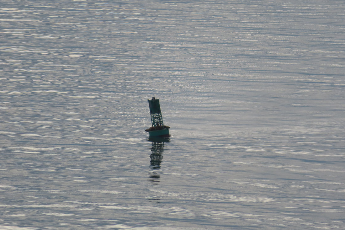 On a rare day without rain, I went south, as far south as I could go on Whidbey Island. Possession Point State Park is 7 miles straight south of Ken’s Korner, except near the end where the road gets wiggly. I turned onto Franklin Road and parked at the end. After the holidays and winter weather, I’m out of shape but determined to improve. It felt like spring. The sap was rising. Birds were singing. I left my coat behind and started to climb the forest trail. Winter storms left trees across the path. I hitched over and crawled under, like limbo, bending way over to dance under a pole. Most logs had been cut through and the brush piled downhill made a great hiding place for the wrens and sparrows calling nearby. Douglas squirrels chirped and scolded along with them, but they were hard to see. Only movement gave them away. The trail, carved into a steep hillside, slithered up and down and all around. I felt like MC Escher must have been involved. Firs, cedars and majestic maples held the slope together along with a thick mat of sword ferns. Licorice ferns climbed the trunks of maples and moss clung to the branches. The cry of eagles echoed through the forest accentuated by the sharp call of a flicker moving between dead branches and snags. I stopped to take pictures and catch my breath. Up and up, stop and breathe. Looking around I noticed colors that blended but the shapes did not. I looked closer and there between tree trunks, pointy deer ears turned away. I waited. Eventually, she turned to face me, and I noted how much easier it is to recognize the eyes, nose, mouth we habitually seek. Most of her body sank below a green sea of ferns. Nearing the top, stairs twisted around tree trunks and with one last huff, I was looking over the railing. Puget Sound opened wide before me as the ferries crossed between Edmonds and Kingston. Mount Rainier supported a ceiling of clouds revealing a forested shoreline dotted with docks and buildings. A train whistled. I pulled out a snack and thermos of tea. Hearing loud belches below, I scanned with binoculars and noticed the tilted buoy crowded with sea lions carrying on like drunken sailors. Their roars billowed across the water. Below me I noticed an immature bald eagle perched at the top of a snag looking out to sea. Then an adult swam lazily through the air to perch just above it. I rarely look down on eagles, but my perch was high on the bluff. Soon I would start down. Down, down, down the trail toward the beach house. Just as an eagle landed on a branch straight ahead, I came upon another downed tree. This one was lying, not across but right on the trail with a thick tumble of branches to either side. It was a mess to get through, and then the eagle was gone. The walk down was faster and brought me to the backside of the wood shed by the old beach house. A cat outside noted my passing with a casual scratch behind the ear. I stepped down off the green lawn. Beyond the beach logs, the tide was out and the cobbled shore exposed. Mergansers, goldeneyes, grebes, loons and cormorants shared the water with passing seals. A gull watched like a lifeguard on a barnacled stone. Cavities in the bluff looked big enough for a bootlegger’s boat. Around the bend the Olympics emerged standing tall in their crisp blue and white. A tanker cruised silently south. Looking up at the bluff, I counted 5 eagles all perched upon the out-leaning snags. I turned and started for home with the sound of drunken belching in my ears and a smile on my face. Directions: From Highway 525 at the Clinton Ferry, drive 2.7 miles to Ken's Korner, turn south on Cultus Bay Road for 5 miles, go straight to East Possession Road for 2 more miles. Turn right on Franklin Road and park at the end. (The next road goes to Possession Beach Waterfront Park.) The forest trail starts up from the far end of the parking area. Bring your Discover Pass.
Bus and Bike: There is no bus service here and the road is windy and steep with little or no shoulder. Mobility: The forest trail is a moderately challenging hike with narrow trails, steep slopes and can be slippery when wet. Several trees were down across the trail. It has a cobblestone beach, best at low tide. 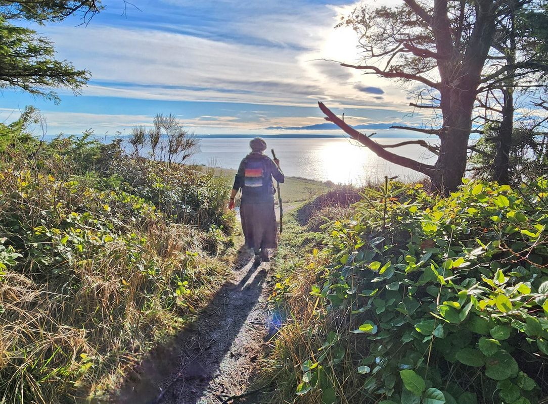 “A good hike starts with a stop at Starbucks,” Kath said. Me, I prefer a water bottle in my pack, along with a Kind bar, or any other dark chocolate bar, or any chocolate whatsoever, be it a truffle or KitKat or chocolate-covered almonds or even Aunt Martha’s chocolate fruit cake, anything chocolate. But I digress, and now I’m salivating a little. After a week of extreme cold and a couple inches of snow which became compact ice, and with the coming week predicted to be warm but drenchingly wet, this past Saturday bloomed with unexpected sunshine, warmth, and clearing skies. Our goal was to hike the Bluff Trail at Fort Ebey State Park to be rewarded with the view at the big meadow, a place Kath had never been to before. So, after stopping at Starbucks, we drove out to the west end of Libby Road, walked onto the beach as the tide began to recede, and headed south toward the park. Kath finished her green matcha tea as we hiked. The Olympics bared themselves beyond a pancake-flat Strait of Juan de Fuca. After walking a half mile on the beach, we found the path leading into the state park. Climbing up the bluff trail, still frozen and slippery in places, a side trail took us directly above Point Partridge; from here we could see Japan if the earth were flat. And we could see our destination ahead, the big meadows of Fort Ebey, sunny green and inviting. Next we entered the hidden bunker that looks out over the strait. The sun’s heat rolled up the grassy bluff and melted the coats right off of us. We climbed and descended the shadowed icy trail, then up the next ridge, Kath’s broken-branch walking stick giving her traction where my big feet gave me skis. Shafts of delicious sunlight drifted down through fog, and lichen hung like tinsel in the trees. The welcome warmth, the still air, the smells of spruce and thawing soil, the twinkling voices of kinglets, and the incredible views made us feel we had entered springtime out of a frozen Narnia. And then we were there. A stalwart fir tree created a window welcoming us to the huge meadow below our feet. If you haven’t hiked this trail before, then imagine that tingling feeling of seeing the first signs of spring as the meadow leads your eyes to the waters, to the mountains, to the sunshine, to the feeling that you have been here before, to the feeling of being home. The Bluff Trail magic had worked. We wandered the meadow like school children, dancing and singing, freewheeling on this January day that felt like June. The trail circled to the gun battery, a dark and stark reminder of the fearful history that has become this transformed stage of peace. After a potty break, we returned down the trail, skipping across the snow as it continued to melt, then taking the short walk to a frozen but restful Lake Pondilla as our icing on the cake. That reminded me: I enjoyed my chocolate bar and a drink of water as we walked back along the beach in the slanting golden sunlight of the early evening. jack Directions: From Highway 20, four mile north of Coupeville, turn west onto Libbey Road. We went to the parking area at the end of the road, but you can also turn left on Hill Valley Drive which leads directly into the park.
By bus: Route 6 Southbound comes to about a half mile from the Libbey beach access. By bike: West Beach Road is a quiet but hilly access route from the north. The Kettles - Rhododendron bike trail leads north from Coupeville to the Kettles which has trails leading directly into Fort Ebey. Mobility: Within the park there are accessible overlooks near the meadow; otherwise the trails are a mixed variety of hilly, with dirt, gravel, and when we were there, ice as a base to walk on. |
Authors
Maribeth Crandell has been a hiking guide in the Pacific NW for over 20 years. She's lived on Whidbey and Fidalgo Island for decades. As a frequent bus rider she easily makes connections between trails and transit. Archives by date
May 2024
Categories
All
|
 RSS Feed
