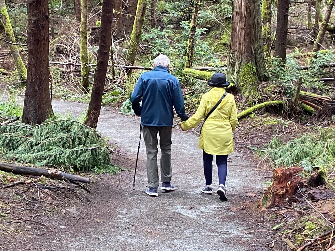
 There are certain people that live on long after their body falls away, like Carl Westling. From 1970 until 1997 he was a science teacher and coach at South Whidbey High School. He was named “Coach of the Year” in 1992 for his work with the girls’ cross-country track team. Since he started coaching the team in 1975, they had earned seven league championships and four state awards. Some of his team members went on to become All-American athletes in college. Westling suffered a series of strokes. Still, from his wheelchair, he continued to work with the Falcon track team as an assistant. He designed and, with lots of volunteer help, built the first trails in the woods just behind the High School at South Whidbey Community Park. These trails are now considered one of the best cross-country courses in the state. They circle ball fields, a skateboard park, playgrounds and picnic shelters. I didn’t know Carl, or run track, though for twenty years, I ran a few miles a day. A back injury slowed me down. Then I discovered that I could see and hear more at a walking pace. Sunday, I went walking with a friend and her dog. As we started out, we heard a mob of robins barking at something. We peered through the trees and saw a barred owl perched in a tree, surrounded by raucous robins. It looked up and down and all around, as only owls can do. We watched for a while before moving on. Though the first week of May was a wet one and the day before had been especially soggy here, these trails were mostly dry and smooth for easy walking... or running. I had come here last spring with a friend in a wheelchair. We’d taken an Island Transit bus to the park entrance on Maxwelton Road and gone right through the park on trails to meet the bus again on Langley Road. There was just one place that might have given her wheelchair trouble. Alongside the upper soccer field, the trail slants and the edges are soft. All the other trails could easily support someone on wheels, or someone using a cane, like the fellow we met on our walk. The Falcon Trail at the south end of the park is steep in places but the rest have a gentle grade. These trails were well designed and constructed, well-marked and well maintained for anyone whether they walk, run or roll. Almost everyone we passed had a dog. Dogs are ambassadors that reach out to meet and greet their canine counterparts. Holding the end of the leash we are pulled together to say hello and ask about each other’s animals. One looked like Toto. There was a sweet white one and a charming gold one. There were hounds with beautiful brown eyes and huskies with brilliant blue. Each looked for a little sniff, a pet, a smile and a word. There were pet poop bag dispensers strategically placed and we didn’t see anything left behind for the track team, or anyone else, to step in. Carl Westling and his wife, Pat, had traveled widely including going to 3 Olympics in Atlanta, Barcelona, and Los Angeles. Before he died, Carl told his wife he wanted to continue to travel the world, so when he was cremated, his ashes were dispersed into small, green bottles. His friends and former students have carried them on their global adventures. His remains were taken on a safari in Africa, run a marathon in Athens, scattered on the Nile, climbed Mount Saint Helens, trudged the snows of Alaska, and cast upon the waters of Tierra del Fuego. And when you’re taking a walk on the trails at the South Whidbey Community Park and the High School track team runs by, you can bet he is there, too. Maribeth For a map of these trails click here. Directions: From Highway 525, 3 miles north of Clinton, turn north at the light onto Maxwelton Road. Pass the High School and take the next right into the park.
Bus and Bike: Island Transit Route 60 goes to the park entrances on Maxwelton Road and Langley Road and can carry 2 wheelchairs and 2-3 bikes. Maxwelton Road is fairly flat, has wide shoulders and slow speeds through the school zone, so it's a good place for a bike ride. Wear bright colors for safety. Mobility: This park is a good place for people of every ability level. Wheelchairs do well on all but the trail alongside the upper soccer field. There are steep sections on the Falcon Trail at the south end of the park.
0 Comments
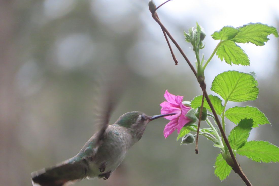 It was a nice weekend, overcast but warm. I felt like I was coming out of hibernation at last and I was up for a climb. I met Lee and her dog, Piper, and we drove down to the southern tip of Whidbey Island to the Dorothy Cleveland Trail. Her friend, Jan Smith, spoke of Dorothy shortly after her death in January 2000, “She had a spirit of adventure. She had a ton of energy.” You would need it for this trail that goes up and up and up for ¾ of a mile. I remember Dorothy Cleveland as a community organizer whose name was always in the paper hosting events for the League of Women Voters, or chairing a meeting of the Soroptimist, or the Langley City Council, or one of the many other organizations she put her energy into. She drove a little red MG Midget with a license plate that read “GoByBus” and helped start Island Transit. She was an elected member of the South Whidbey Port Commission. So this trail, owned by the Port of South Whidbey at Possession Beach Waterfront Park, is a fitting tribute to her legacy. Lee put a leash on Piper and we took the sidewalk below the caretaker’s house, across the road and over the bridge to the kiosk. A poster showed how the trail twists and turns and suggests a few birds you might see, but the 390 foot climb looks pretty flat on paper. Soon I was envious of Piper’s tendency to pull Lee on the leash. I stopped frequently to take pictures and catch my breath. It has been a long winter. Though no rain had fallen for a few days, the trail had some muddy spots. We danced across them and kept climbing. This park and neighboring Possession Point State Park, have steep trails through maple forests. One hefty snag with bark falling off, exposed the twisted, polished, grain of birds-eye maple. It glowed golden against the grey and brown surroundings. As we climbed, we noticed salmonberry blossoms erupting in their brilliant pink. Hummingbirds noticed, too. We kept climbing. The road snaked around below us with an occasional passing car. We could hear a distant train on the far shore of Possession Sound. But mostly we heard tiny kinglets and chickadees, and the distinctive call of ravens and eagles. One sailed silently above the canopy heading for the water. Steps and benches along the trail assisted us to the top where we rested. Even Piper breathed heavily but she still got excited when someone said, "Squirrel!" An old water tower stood in the forest nearby and a charming little fountain teased us, but no. A few houses sat just beyond the summit on the west side of the ridge. We turned back to the east and began our descent on a little loop back to the main trail. We got a few peak-a-boo views of the water and mountains, but that will be closed soon when the trees leaf out. After coming down the trail we walked the waterfront enjoying this fine spring day where sturdy tables and barbeques await summer picnics. A cattail marsh sang with red-winged blackbirds. An eagle sat majestically in a tree looking over the water. I think Dorothy would be pleased that this trail is named for her at this park that brings people out to appreciate our amazing community. I could just imagine her little red sports car zooming up this curvy road to another city council meeting. You go girl! Maribeth Directions: From Highway 525 at Ken’s Korner shopping center (3 miles north of Clinton), take Cultus Bay Road south almost five miles. Cultus Bay Road will turn right but keep going straight on Possession Point Road and continue another 1.5 miles until you see the sign for Possession Beach Waterfront Park. The trail starts near the boat launch with a little bridge and kiosk leading into the woods.
Bus and Bike: There is no bus service to this end of the Island and I would not recommend it for cyclist on these roads with their steep hills, sharp curves and no shoulders. Mobility: The waterfront park has paved sidewalks and steep lawns. The beach area has a wide path of packed gravel to access the picnic tables. There’s a boat launch where they put a dock out in summer. Vehicles can drive close to picnic tables and beach access. The trail itself is narrow, steep, muddy in places and challenging. 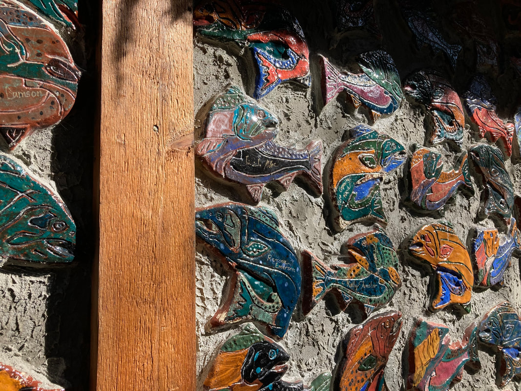 In honor of Billy Frank Junior’s birthday, I visited the Outdoor Classroom this week. It’s a short loop trail with a boardwalk and a deck overlooking Maxwelton Creek. Yet this small site has had a lasting impact on our local community. Maxwelton is the largest watershed on Whidbey Island. The headwaters are near Highway 525. Its course weaves south through the valley among homes, farms, beaver ponds, and reed canary grass all the way to Maxwelton Beach. In the 1850’s the creek was thick with salmon, but dikes, tide gates, and development have significantly altered the landscape. The Outdoor Classroom was established thirty years ago to help protect and restore the creek and educate students and watershed residents. The project started with two teachers whose students raised salmon in their classrooms. After a few months, the growing fish needed to be released into a stream. Creek side property owners allowed the students to come and free their fry. When a few acres came up for sale on Maxwelton Creek the teachers formed a non-profit organization, Maxwelton Salmon Adventures. The community donated money, energy, and materials to buy the property, build a classroom and make trails and learning stations. People who made donations got their names on a colorful ceramic fish plastered to the side of the building. When the effort was expanded to other watersheds, the name was changed. Whidbey Watershed Stewards has worked on restoring Robinson Beach, Old Clinton Creek, and the Freeland Wetland Preserve where there’s another trail that’s open to the public. Over thirty years many students have visited the Outdoor Classroom. An education director trains volunteer instructors. Classes of K-5 students rotate through three stations, one on the creek, one in the classroom and one on the trails. Each season students focus on different aspects of the natural environment. They study the stream, birds, native plants, mushrooms, and of course, salmon. The fish raised in the classroom are still released at the site each year. On my recent walk, the trails were littered with branches from winter storms. The stream was dark brown with foam piled in the corners due to it passing through a peat bog in the valley. At the classroom I could see teaching materials stacked inside. And there were signs of spring. Indian plum bloomed in the sun. Skunk cabbage emerged in the wetlands. Chickadees foraged in the treetops. I sat on a bench and listened to the murmuring creek. A work party is planned to clean up the site. Next month volunteers will undergo training and classes will begin. Years ago this was one of my usual and accustomed places. I was one of those educators, leading small groups in learning activities. Most classes come once or twice a year through elementary school. By the time they reach fifth grade they have a good understanding of the importance of wildlife habitat. It gives me hope. For those who don’t know, Billy Frank Jr. was a member of the Nisqually Tribe who fought for Native American fishing rights in the 60’s and 70’s. Due to declining populations of salmon there was an all-out war over fish. Billy Frank was first arrested for illegal salmon fishing when he was just fourteen. He went on to become an activist and spokesperson for his people. The case over treaty fishing rights went to the U.S. Supreme Court. In 1974 Judge George Boldt affirmed that Washington State tribes had the right to fish in their “usual and accustomed places” as was stated in the treaties. The Boldt Decision made the twenty treaty Indian tribes in western Washington co-managers of the salmon fisheries along with the State of Washington. Billy Frank Jr. served as chairman of the Fisheries Commission for over thirty years bridging the cultural divide and working on environmental sustainability on behalf of all of us. President Barack Obama awarded him the Presidential Medal of Freedom posthumously in 2015. To learn more about the Whidbey Watershed Stewards and the Outdoor Classroom, or to volunteer visit here. Maribeth Directions: From Highway 525, 4 miles north of Clinton on South Whidbey, turn south on Maxwelton Road and drive 3.4 miles. You'll pass Erickson Road just before the Outdoor Classroom sign on the left. French Road is just beyond. Take a moment to look at the beautifully carved sign by Pat McVay.
Bus and Bike: There is no bus service to the Outdoor Classroom at this time, but it's an easy 3.4-mile bike ride on a wide shoulder along Maxwelton Road. Two or three bikes will fit on a bus bike rack. The fare free Route 1 bus will stop at Maxwelton Road and Highway 525 Monday-Saturday. For a schedule click here. Mobility: The trails are flat but narrow with roots and branches that may pose a problem in places. The boardwalk is wide enough for a wheelchair and the covered deck has benches overlooking the creek. There are no restrooms. 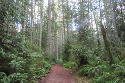 The sun was out, I was restless, so I went to explore the Trustland Trails near Bayview. I’d heard there were some new trails and I wanted to try them out. Studying the map at the trailhead kiosk, there were many options to choose from! Lots of loops within loops. I decided to make the biggest loop and started in a counterclockwise direction. It was smooth sailing along the first stretch as I walked west on Mossy Way. I saw the church through the trees as I turned south on Swordfern Lane. I was walking in an emerald forest. There was so much lush, green vegetation. Salal, sword fern and evergreen huckleberry made a hedge on each side. Tall trees made a green canopy above. This is so different from the deciduous forests where I grew up. There a carpet of brown leaves lay thick on the ground and bare branches rattled in winter winds above. But here, in this Evergreen State, we have lush life all around us even in the depth of winter. The trail was smooth and wide with little paths connecting local neighborhoods. I began to meet people walking their dogs. First, a big, friendly, yellow lab with its equally friendly people. Later, a nice older couple with an older speckled dog, pulling them along. And finally, an old friend with her two small pooches who perched on their favorite stump for a treat. I looped around Alder Alley and came back north on the newly constructed trails from Cedar Hollow to the Overlook Trail where there’s a steep ravine below. On the Ravine Loop I started noticing the curious shapes of trees and stumps. One had a spray of salal erupting from the top and hanging almost to the ground. Another large stump had the tell-tale springboard notch, evidence of the use of a two-man saw. The notch looks like the stump has an open mouth and will tell you about it if you stay awhile. As I came back to the Cedar Hollow trail, there was a tree with the candelabra of limbs that started growing straight up when the top was broken. And another tree with a loop in the trunk. I stopped in my tracks wondering how that could have happened. I continued north on the Raven Ridge trail. This is the hilly end of the park. Climbing helped me stay warm on this winter day. After an hour I reached the ADA loop near the entrance. The Serenity Loop is almost level with a surface of packed gravel, easily wide enough for two wheelchairs to pass. It’s a calm, quiet and lovely forest. The trail is smooth, wide, and inviting. As I was coming out at the parking lot, I met Jan who was just getting out of her car. She was putting her cane away and pulling her walker out. We talked for a few minutes. She loved walking the South Whidbey trails and we laughed about getting lost on a few. She posed for a picture as she set out on her walk around the loop trail. Another friend had told me how she used to bring her father there in his wheelchair. She said it gave him a lot of peace and pleasure. It’s such a blessing to have all these trails here, whether you do the biggest hilliest loop, the littlest smoothest loop, or something in between. They all bring joy and peace to an open heart. Maribeth Take a picture of the map at the trailhead kiosk with your phone or download this one before you go. South Whidbey Parks and Recreation welcome volunteer trail maintainers. Call 360-221-5484 for details. Directions: The Trustland Trails are on South Whidbey Island just off Highway 525, 1.5 miles south of the stoplight at Bayview, 9 miles north of the Clinton ferry. Turn south on Craw Road then take an immediate right into the parking lot. The park has a picnic shelter but no restroom. Gates close at dusk.
Bus and Bike: Take the fare-free Island Transit Route 1 or Route 60 bus Southbound from Bayview. Ask the driver to let you off at Craw Road. Walk 100 yards to the park on the right. There is no place for a bus to pull over off the highway going north, so if you need to go north, catch the Southbound bus, and make a connection to a Northbound bus. The friendly bus driver will be happy to help or call 360-678-7771. Or get a schedule here. Mobility: The ADA loop is suitable for those with mobility challenges. It’s about a ½ mile long and almost level with a smooth, hard packed surface. The other trails vary with a few hills but are well maintained and mostly wide and smooth. |
Authors
Maribeth Crandell has been a hiking guide in the Pacific NW for over 20 years. She's lived on Whidbey and Fidalgo Island for decades. As a frequent bus rider she easily makes connections between trails and transit. Archives by date
May 2024
Categories
All
|
 RSS Feed
