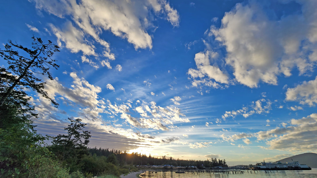
 Can you picture Ship Harbor before people arrived, when the glacial ice had retreated to Canada? Picture sandy tree-lined beaches. Open skies above. Open waters leading to emerald islands beyond. Songbirds and others fly among the reeds, the cattails and willows, the roses and firs, content to find seeds and insects and other simple foods. A heron wades in the harbor, patient in finding foods beneath the shallow bay. Gulls mingle with crows to find detritus and other foods along the wrack line as the tide returns. Above them, an osprey searches for fish beneath the surface. Picture the first peoples arriving here, discovering the waters rich with salmon and shellfish, the forests full of cedar, fields flowering with camas. They built homes along the beach, and plied the waters with dugout canoes, bringing in rich harvests of marine life and more. Children played along the shoreline as the communities grew. Eagles and ravens, otters and others shared the land and seashore. Picture the first European explorers sailing into these waters in the 1790s, finding flourishing communities and abundant natural resources. Picture a hundred years ago, when the shores of Ship Harbor were covered with canneries and docks, piers and pilings, machinery throbbing and humming throughout the day and night as fishing boats brought in salmon and other fish to be canned. Mess halls, bunk houses, carpenter shops and offices filled the backshore. Chinese and tribal workers cleaned and packed the salmon, handling thousands of tin cans made here daily. Railroad tracks circled behind it all, against the hillside. Refrigerators were still a novelty, requiring electricity, so tin cans served to preserve these precious foods. Picture twenty years later, with power lines coming into communities. Most homes exchanged their iceboxes for electric refrigerators, so the demand for canned food began to decline. The canneries of Ship Harbor were dismantled, the pilings and piles of slag the only remaining evidence at the beach. Picture the early 60s. Washington State Ferries built a ferry dock here to better serve the San Juan Islands. The westernmost point became a boat dock and car loading area. The sandy beach begins to return, with wetlands reclaiming lands once covered in canneries, shops, and houses. Picture the late 90s as city parks, tribes, schools and others sought funding to open the harbor to the public. Private developers purchased and then donated the property; together they developed an interpretive trail along the edge of the wetlands, through the former shops and home sites, and along the storied beach of Ship Harbor. Picture last weekend. Sandy tree-lined beaches. Open skies above. Open waters leading to views of emerald islands, enticing and inviting us to explore. Roiling clouds of the morning gave way to blue skies and a warming sun. Hikers come and go along the beach, moms with kids, couples of all ages, families, lovers and the lonely strolling the boardwalk. We sat on the soft sand and let it waft through our fingers and toes. We strolled the length of the beach, turning inland at the westernmost boardwalk. The cattails were silent in the afternoon sun, the wildlife waiting for the cool of the evening. The forests too were silent. I returned near sunset time. Again, it is quiet. There are hikers, some as couples, some alone, some waiting for a ferry, some just out for a walk, everyone enjoying the pleasant late-August warmth of this evening. Purple martins fly about their houses built on the ancient pilings. A heron wades in the harbor. Gulls mingle with crows to find detritus and other foods along the wrack line as the tide returns. And above them, an osprey searches for fish beneath the surface. The calm harbor waters lap at our feet. Ferries come and go, taking their riders to the emerald islands, while we walk, and watch, and remember, and dream. jack To better see the word pictures I suggest above, watch this 2:40 minute video illustrating the centuries of stories at Ship Harbor. https://youtu.be/9fBmUivrxJc Directions: From Anacortes take 12th Street west, which becomes Oakes Avenue. At the roundabout a half mile before the Washington State Ferries exit, turn right on Ship Harbor Boulevard, and then left at the "T" on Edwards Way. Follow it down to the water's edge.
By Bus: Take Skagit Transit 410 from Anacortes to the Washington State Ferry Terminal. Trails lead from the car-parking waiting area to the beach, which is the west end of Ship Harbor Trail. By Bike: The 12th Avenue/Oakes Avenue route has a lot of 30-mph traffic, but a good bike lane from "D" Avenue west. The road is gently rolling except for the last steep drop to the beach on Edwards Way. Mobility: The beach is very soft sand. The trail just above the beach is wide and finely graveled or a solid boardwalk, with one 100-foot slope at the very beginning to get down to the beach level. There is no ADA access from the ferry parking area.
0 Comments
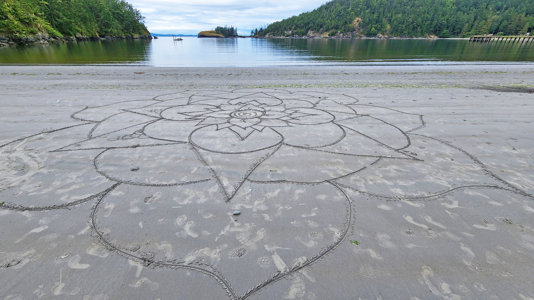 Summer Solstice, 2022. Literally, the day the “sun stands still”, and yet we know it is just the moment it changes direction, the earth moving on in its tilted voyage around the sun. But on this day, we celebrate the sun, its fullness in spending a long day with us. It is now summer. Kath and I celebrated Solstice by hiking to Lighthouse Point, as did dozens, maybe hundreds of others. One never knows what will be found on a hike. Today emphasized that point, many times, in many ways. This day was calm, cloudy but clearing, and warming. Elsie the elephant seal had just arrived at Bowman Bay after molting for several weeks near our place in Anacortes. People arrived in cars, with dogs or kayaks or picnic baskets or hiking poles or long-lensed cameras, ready to venture forth and enjoy the magic of the day. We passed clumps of people of all sorts, kids and the elderly, strong marchers with packs, and slow strollers with canes. We walked onto the sandy beach between Bowman Bay and Lighthouse Point. There in the sand, in artistic handwriting, “Stephanie” had created a lengthy pledge of affirmations and commitments to herself, spoken to the world on this first day of summer. 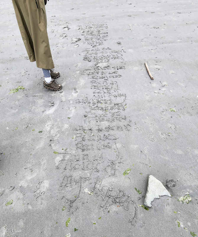 I am beautiful I am kind I am strong I will not Give up I will stand tall I will love myself I will care for myself I will be kind to others I will always be true to myself I have the power to be strong And rich In money and love I will only manifest goodness What I create becomes reality I am in charge of my happiness Nearby we found a drawing of immense beauty and size, an intricate work of art, inspiring in its grandeur – and as temporary as the tide, sketched in the sand as the waters receded. We followed the trail onto Lighthouse Point, past a curious chickaree, past roses blooming forth while they can along the side of the trail, the sunshine splashing greens and golds in the trees and sparkling on the waters of the south cove. I am always joyful, playful, and inspired by the interplay of water and tides and grassy headlands and woodlands here. We scrambled up the small point, and spelunked the tiny cave in the cove. The trail leads west toward the lightbulb at Lighthouse Point. Gentle breezes flowed over the meadow and through our minds. We clambered down to the beach below Lighthouse Point, using roots for handholds going down and back up; then entered the high walls of salal along the headland, exploring the many fingers that jut out toward Deception Island. On the northwest corner we lay in a field of mosses and grasses, watching waves caress the islets of Bowman Bay and Rosario Head beyond. The Olympics lay shrouded in clouds while we bathed in the glorious sunlight of summer. We rested, having slowly sauntered and scrambled for nearly two hours to get here. The tide now rested too, slack, catching its breath before returning to flood back over the beaches. We walked back, listening to orange-crowned warblers, white-crowned sparrows, and the haunting Swainsons songs. The deep woods echoed silence. Soon we emerged onto the beach to wander past the artwork and inspirational words again. The waters of the sea lapped gently, rising inexorably to eventually erase the dreamworks and create a new canvas for tomorrow. The universe renews her palette minute by minute, day by day, year by year, as visitors such as us come and go, come and go. Flowers become seeds and wait for fall. Elsie will soon head south to Hawai’i. The trees too stand firm, standing still in our eyes, but in their time rising and then falling as the centuries go by. And so we live our lives, stories written in the sand. jack Directions: from the Deception Pass bridge, drive north on Highway 20 a half mile. Turn left on Rosario Road, and then an immediate left onto Bowman Bay Road. The trail starts at the south end of Bowman Bay.
By bus: the nearest service is to the bus stop just north of Cornet Bay Road on Whidbey Island, about a mile south of the Deception Pass bridge. By bike: Highway 20 and Rosario Road are hilly, busy and narrow, but they can lead you to Bowman Bay. Mobility: the beginning of the trail is flat and graveled. It soon climbs a rocky bluff on a rough and rocky trail. At low tide the bluff can by bypassed by walking the sandy and gravelly beach southward. The trail on Lighthouse Point (Reservation Head) varies in terrain, sometimes steep, rocky or filled with roots, in other places easier going. Permits: A Discover Pass or other valid pass is required. 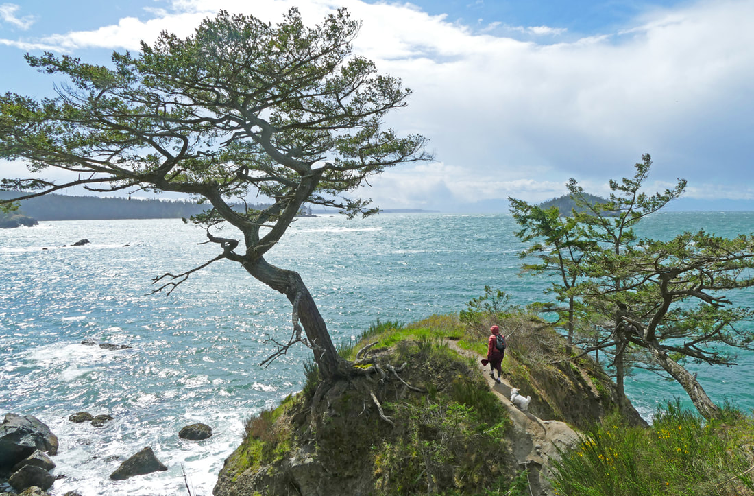 Fun! That’s what our hike was, pure fun! The wind blew strong out of the west, not its usual direction. The sun shone brightly, sparkling in the wind-scrubbed sky. The air was warm…ish. “Where should we hike?” I asked Kath. “Somewhere fun,” she replied, and we both said “Bowman Bay and Rosario!” Emerson the elephant seal was still lounging around the parking lot at Bowman Bay. Park staff had tried to open the parking lot for visitors, but Emerson delighted in waddling over to cars, oblivious to the law that we all have to stay a hundred yards away from him. And then he just plopped himself down in the middle of the lot and took a nap, so the lower parking area was closed once again. The beaches are now open, but who knows where he will wander, so be flexible if you go there in the next couple of weeks. A big thank you to all the volunteers who help teach us about Emerson’s habits and capture the stories and photos of his childhood antics. When we arrived, Elizabeth Drozda and Jann Ledbetter were on hand near the boat launch, telling stories about him, sharing photos, and reminding visitors of the need to give him space. I took my photo of him with a telephoto lens from a proper distance. But the sun and wind continued to beckon. Kath and I wandered down to the beach. Waves rolled in from the Strait, sparkling in their blue and white. The gravel glistened, seagulls turned on the wind, children and dogs and an adult or two cavorted and ran and played, feeling like spring is back if just for a day. We climbed the bank to the Bowman - Rosario trail and looked back over the expanse of Bowman Bay, spread out like a welcome mat before us, waves rolling in. We’ll be back soon, we said, not realizing how many more pleasures awaited ahead. We hiked up the short but steep trail, seeing ferns dancing in the wind, trees waving their arms, silhouetted by the shimmering waters of the bay. People passed in clumps of two or three, smiles on their faces. We came to the tree that needs a name, alone on a promontory near Rosario, and we lay in the small bowl at the point, perfectly sized for two people and a dog to lie down and soak up the sun out of the wind. Waves crashed all around us. Bees busied themselves on newly-emerged flowers. The sun beamed down. After a joyful rest, we finished the hike to Rosario, the green grass inviting picnics and playfulness. The isthmus to Rosario hummed with people. We walked onto the dock and rode the floats like a rollercoaster, the waves rising and falling beneath us, keeping us dancing. KoKwalAlWoot watched stoically, a look of wisdom on her face, and maybe a twinkle in her eye. We followed the gentle south trail to the top of Rosario, as a glaucous-winged gull flew along nearby, loving the eddy of a breeze. At the top I unzipped my coat and raised it over my head like a sail, letting the winds pick me up off my feet a little. (Obviously, do not do this near the edge.) Waves pounded the base of Rosario; oystercatchers squawked and laughed on the rocks offshore. The blues and whites of the sea were achingly beautiful. Time lost all meaning as we hung out, but it was a tad cold up there, so we headed back down, watching Harlequin ducks playing in the surfline. We retraced our steps back toward Rosario, playing leapfrog with other hikers who, like us, would walk a ways, then stop to enjoy the amazing day. Eventually we dropped back down to Bowman, the sun still a welcome friend, the wind a playful partner, the sparkle of the day unforgettable. jack https://youtu.be/QCTEPhJa5VQ A one-minute video of some of that sparkle. Directions: From the Deception Pass Bridge, drive north a half mile, turn left at Rosario Road, and immediately turn left again into Bowman Bay.
By Bus: There is no direct bus service; Island Transit does stop near Cornet Bay Road a mile and a half south of Bowman Bay. By bike: Highway 20 has narrow shoulders in this area, and mostly high speed limits. Rosario Road has lower speed limits, but also has narrow shoulders. Mobility: Bowman Bay has a flat graveled trail along the waterfront, as does Rosario. The trail between the two is somewhat steep and filled with rocks and roots. 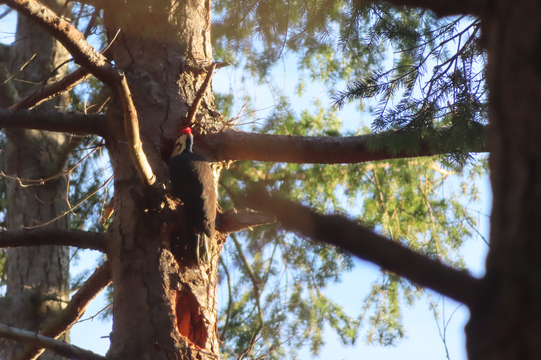 Snow. You either love it or… well. Me, as long as I don’t have to drive in it, I love it! My feet are all-terrain vehicles. I was sad to see it melting so soon in another “river of rain”. Still, I thought maybe we could find some if we looked deep enough in the woods. So Sunday, under brilliant blue skies, a friend and I turned toward Anacortes and the trails at Whistle Lake. The roads were clear almost all the way. The parking lot was full of cars driven by brave souls who managed the last stretch of curvy, icy, snowy roadway. We walked up the old forest road toward the lake, adjusting our stride to the changing surface underfoot of soft mud, crusty snow, or slick, compact ice. A bold sun sliced between the trees promising warmth and light ahead. Nearing the lake, the hammering of a pileated woodpecker drew our attention. This striking bird, one of the largest in the forest, was intently drilling holes in a rotten snag sending wood chips flying. It typically makes a rectangular hole and excavates cavities that other critters can use for foraging or nesting. I remember the first time I noticed one, not by its bright red crest, but by the ferocious thwacking noise that carried across the backyard and through the closed windows of my southern childhood home. I went outside to see who was hammering in the woods behind our house. My mother identified it for me. I still find it fascinating to watch, chiseling deep holes and foraging for insects. Seeing it reminded me of its look alike, the ivory billed woodpecker. In 2021 the U.S. Fish and Wildlife Service proposed listing it as Extinct. But many people still hold out hope for these magnificent birds of the southeastern woodlands. The ivory billed, largest woodpeckers of North America, depend upon vast swaths of old growth forest. As the trees were cut, the woodpecker population plummeted. The most recent credible sighting was in 1944. Many experts have sought out the 'Holy Grail of Birds’ to no avail. Alas, despite extensive searching, it may never be seen again. Southern forest habitat is improving now, so if there are any left, perhaps they’ll make it. Keeping it on the Endangered Species List allows us to keep a candle of hope burning and protects the habitat that supports them and many other species. It’s a lesson we keep learning, wildlife needs wild land. The slightly smaller pileated woodpecker was able to adapt to second growth forests and are found in the eastern US, mid-western Canada and here in the Pacific NW. On our islands we have a few places with large swaths of protected wild lands. We’re fortunate to live in a place where we can hike for miles, by sunny lakes, marshy wetlands and frozen ponds. But for some birds and wildlife, it’s not just a pleasant place to spend a day, it’s a matter of survival. We saw a lot of people out walking last Sunday. Some rode bikes. Some brought fishing poles. Most were walking their dogs. (Or was it the other way around?) I’m so grateful to the City of Anacortes for preserving thousands of acres of wild lands around the south side of town for people and wildlife. And I’m thankful for the staff and volunteers who build and maintain trails there. On our drive home, every trailhead we passed was packed with hikers anxious to be outdoors and soak up some sun after a week of dismal clouds and rain. Whistle Lake is surrounded by trails that twitch and turn. You can take a different route each time you go. This bright, sunny day, we walked to the lake, spied ducks and cormorants, then circled to the east through the woods passing frozen ponds, marshes and snowy fern banks. We felt truly blessed by the sun, the snow, and all the wild lands we have and those that protect them. (Get a map below.) P.S. This week the U.S. Fish and Wildlife Service reopened a public comment period on listing the ivory billed woodpecker as extinct. Read more here. Read more about the search for the ivory billed woodpecker here. Get a map of Whistle Lake trails here. Directions: From Hwy 20 at Sharpe's Corner Roundabout drive west toward Anacortes. At the next roundabout on Commercial Avenue turn south (3/4 of the way around) and drive up the hill. Turn left at the T on Fidalgo Avenue, turn left again on to Hillcrest, then right and right again onto Whistle Lake Road (around the cemetery) and follow that road until, near the end, you'll see a sign to Whistle Lake. Don't leave valuables in your car.
Bus or Bike: There is no bus service and it's not a great place to bike to. However, if you bring a mountain bike, you may ride the forest road to the lake. Mobility: The mile long walk from the parking lot to the lake is gentle and wide but can be muddy or even snowy at times. |
Authors
Maribeth Crandell has been a hiking guide in the Pacific NW for over 20 years. She's lived on Whidbey and Fidalgo Island for decades. As a frequent bus rider she easily makes connections between trails and transit. Archives by date
May 2024
Categories
All
|
 RSS Feed
