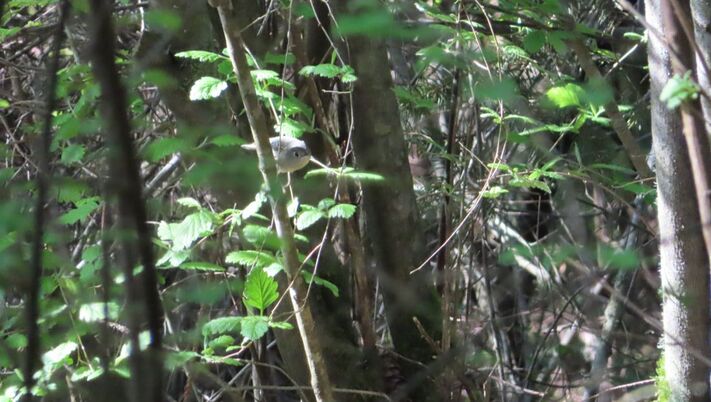
 When people ask me “What’s your favorite trail?” I used to think of the Ebey’s Bluff Trail. It is stunningly beautiful with expansive views of the water and mountains, a beach walk and ridge hike in one. But over the years I find myself gravitating to the lesser-known Pratt Loop Trail that stands meekly in its shadow. My sister, Sue, was one of the most popular girls in school. She always dressed well and wore her hair and make-up tastefully. She hung out with the cheerleaders and football stars. I came along a few years later, a little sloppy and shy. I was known as Sue’s little sister. Early last Saturday morning, I drove past the Sunnyside Cemetery and parked behind the Ebey’s Landing National Historical Reserve office. I turned away from the Bluff Trail toward the Pratt Loop Trail, and began to think about it metaphorically. The Ebey’s Bluff Trail is probably the most popular trail on the Island. The Pratt Loop is not so showy and often overlooked. You have to get to know it before you really appreciate it. I love to walk there on spring mornings with my ears and eyes open, looking for birds. Heading north from the parking lot, I could peer over the shrubs at the blockhouse in the cemetery next door. Indian plum and Oregon grape bloomed adding color to the thicket of wild rose in the hedgerow. The sun shone brightly. Birds were singing. Cows were lulling around on the pasture next door. I carried binoculars around my neck and a camera in my pocket. Hummingbirds posed briefly at the tippy top of an elderberry. A savannah sparrow perched on a slender, yellow flower. The old snag that used to stand in the middle of the field has finally fallen. It lays on its side still serving as a centerpiece. At the historic barn, I stopped at the map to see the connections with the Kettle Spur Trail and traced my route around to the loop to the Ridge Trail that would take me by the Sarah and Jacob Ebey cabin and back to the trailhead. Standing at the edge of the forest, I could hear woodland birds calling, a nuthatch, woodpeckers, and chickadees. Flickers drummed on the tallest snag waking up the neighborhood just like they do on streetlights and chimneys. Golden crowned kinglets dove into the ocean spray that form a canopy along the trail. Hummingbirds were humming, warblers were warbling, and woodpeckers were pecking. I walked ahead and then came back, following their calls, trying to get a look at some of these songsters. A jogger passed by. A few minutes later, he returned. I grinned as both of us were going around in circles. The trail weaves into the woods, then out to the field, then back into the woods, deep shade, bright sun, deep shade, like a swimmer rising to the surface, taking a breath, and submerging again. Field, forest, field, forest until one reaches the far side of the pool and climbs out. The warm sun shines and distant mountains come into view. I followed the trail across the fields as views of Puget Sound and Ebey’s Prairie unfurled before me. Turning toward the Sarah and Jacob Ebey cabin, hordes of people appeared headed toward the Bluff Trail. First a group of twenty chattering away, then a group of ten, and right after them, a group of seven. But who’s counting? I’m happy to have a quiet walk on the Pratt Loop seeing only a few other people in the hour I spent there, but many more birds. After they’d passed the cabin and the quiet returned, I got pictures of a chipping sparrow and red winged blackbirds. I was happy with my walk and all the birds I'd seen and photographed. Rounding the bend toward the parking lot, I heard quail and saw them scurry beneath the hedge. They’re a little shy. I can relate. Maribeth Ebey's Landing National Historical Reserve is cooperatively managed by the National Parks, State Parks, Island County and the Town of Coupeville. The Pratt Loop is just a small part of the 17,000 acre reserve. Learn more here. Directions: From the stoplight on Highway 20 in Coupeville go northwest 1 mile and turn south on Sherman Road. In half a mile turn right on Cemetery Road. The parking area is at the very end. Go slowly on this single lane blind curve. Restrooms are at the trailhead. Dogs must be on a leash and bring a bag for pet waste.
Bus and Bike: The nearest bus stop is at Sherman Road less than a mile away. Take Island Transit Route 1 Monday-Saturday. There is a paved bike path that parallels the highway for 4 miles from Rhododendron Park to the Kettles Trails near Fort Ebey State Park. The Kettles Spur trail connects this paved bike path with the Pratt Loop Trail. Bikes are not allowed on the trail but a bike rack is provided by the bike path. 2-3 bikes fit on an Island Transit bus. Mobility: The Pratt Loop is flat and most of it is on farm roads that are easy to walk or ride with a mobility device. As the trail enters the woods there are more roots and the trail narrows but is not rough. The loop 1.3 miles long.
0 Comments
 I’d just heard on the car radio that it was the anniversary of the sinking of the Titanic (April 15, 1912). Then I arrived at Long Point and found this, a ship had floundered on the beach, flags still flapping in the brisk spring breeze. I scanned the water for icebergs. Though spring has been long in coming, on this day the sun shone brightly and sent puffy white clouds sailing across the deep, blue sky. I approached the stranded vessel trying to imagine it's mishap. Had it broken loose of its mooring and washed ashore with no one aboard? Were the sailors unaware of this long point at high tide despite the name on a chart? Had the wind been overpowering, the current too strong to avoid sailing onto the beach? At least, it was a low, sandy beach and not a rocky, inaccessible bluff. No harm done, not much anyway, except the embarrassment of your sailboat lying up on the beach for all to see. It reminded me of how I’d almost suffered the same fate once just north of here. A strong wind from an unexpected quarter, drug us off our quiet anchorage late at night. We were in an historic long boat powered only by oars and sails. It was dark. The wind was howling. Waves were pounding our little vessel. We radioed “May Day”, donned our survival suits and were rescued near Deception Pass. But this day was bright and promising. It was low tide and I was out for a relatively uneventful walk between Long Point and Coupeville. No life rings or survival suits necessary. There was plenty of sunshine and white sand though a cool breeze kept me bundled up in all my layers. I made my way westward. Beyond the beautiful waterfront homes the bluff rose high up on my left. A few trees grew just above the sand trying to hold on to the sluffing soil. Maples were leafing out in their chartreuse party dresses showing off their dangly earrings. A few trees had tipped over and I was glad I had a wide beach to navigate around them. If the tide were higher, it would be quite the logstacle course. I approached a little spring trickling out across the sand where bright green algae grew. A perfect place for otters, I thought, and I looked for tracks. Instead I was accosted by kingfishers rattling around me. Eagles called from the tree tops high above. One called to another as a third cruised by. Ravens croaked from the forest. Hummingbirds zipped to red flowering currant. Mergansers, goldeneyes and eared grebes paddled just offshore. Gulls and crows hopped along the water’s edge picking up bivalves, lifting off and dropping them on the beach. Crack! It was an all-you-can-eat buffet of mussels and clams. I was getting hungry, too. I passed another cluster of beach cabins. These were more modest and looked like they had some history. When I was here last summer, people were out cleaning kayaks, roasting hot dogs and marshmallows. I walked on and again the bluff rose above me. Around the corner my favorite house came into view. It looks like the home of a pirate, or a wizard, or some other whimsical creature, with its red cap and green cape. That's where I turned around, within sight of Captain Coupe Park with it's boat launch, dock and picnic table. I took a picture of the Coupeville Wharf and headed back. I could hear the subtle swish of the tide changing and didn’t want to get stranded somewhere along the way with the high bluff towering over me and not enough life boats. Maribeth Directions: This beach can be accessed from the Captain Coupe Park on 9th Street in Coupeville, 6 blocks east of Main Street. Or from the stoplight at Main Street and Highway 20, drive south 2.7 miles to Morris Road. Turn left and take a quick left onto Parker Road. Drive 1.3 miles and turn right on Portal Place. In a short distance turn left on Marine Drive and follow it to the end.
Bus and Bike: Fare free Island Transit route 1 and route 6 go through Coupeville on Main Street. You may get off at the Methodist Church and walk or ride east 6 blocks on 8th (a quieter street for pedestrians and bikes), then hop north 1 block on Gould to 9th and go one more block east to Captain Coupe Park. Walk east on the beach. Mobility: The Long Point end of this walk is a soft, sandy beach. However, there are driftwood logs and the beach sand is too soft for most wheels. The beach gets rockier as you go toward Coupeville. Captain Coupe Park has a dock, boat launch, picnic table, barbeque and restrooms on a gently sloping lawn. 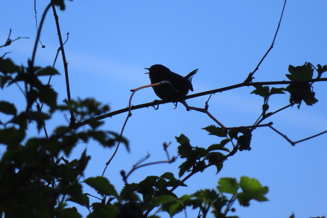 If you don’t like songbirds, wildflowers or expansive views of the Olympic Mountains across the water, don’t come to Admiralty Inlet Preserve. Especially in spring! And by all means DON’T volunteer to help do restoration work with the likes of Kyle from Whidbey Camano Land Trust and his motely crew. Especially on a sunny, beautiful, day in April! You would have an endless supply of little tufts of grass to plant among all the other little tufts of grass, flats and flats of fescue. At the end of the day you’d step back to admire your work and not be able to tell if you were there at all! They call it restoring the native prairie! I went for a walk there and found some honest-to-god flowers at the edge of the bluff. Daffodils! I don't suppose they're native but they are cheery after a long winter. I couldn’t pick them because of the fence between me and the bluff. It’s a long way down and I guess they think some idiot would get too near the edge and just tumble on over never to be seen or heard from again. As I stood there, I could hear a wave rolling down the beach from Ebey’s Bluff all the way to the Coupeville Ferry. But I couldn’t see it because it was straight down! There were swallows shooting straight up from below the bluff, rocketing over my head, turning and dropping back down again. It looked like fun... if you have wings. Of course there’s mud on the trail, here and there. I haven’t been on a trail in months that didn’t have mud somewhere. You just have to toughen up and soldier on. I admit that split rail fence all along the loop trail adds some rustic charm, but it also gives those noisy birds a place to perch and sing their tiny avian hearts out. If you scare them off they just fly up into the nearest tree, or hide in a thicket and pick up right where they left off. The same song over and over and over again! And careful! Those cottontails are constantly zig zagging across the trail when you least expect it. They dart out from under the hedges of wild rose and berry bushes intentionally trying to trip you up. Or those pesky chipmunks that scurry around in the woods. They look so cute until you pull out your camera, then shazzzam! They’re gone! And another thing, the parking lot across the road is blocked with orange cones. Huge earth-moving machines are expanding the parking area, so there’s no place to park right now! Never mind that there’s a fare free Route 6 bus that comes right by the trail every other hour Monday through Friday. If you ask the driver they can stop by that bright blue house across the road from the trailhead kiosk that’s hiding behind the hedge. On Saturdays the Route 1 bus will bring you to the Fort Casey Inn, which is pretty close. But of course, people would rather drive, even though gas is so expensive. Curiously, I saw a group of teenagers riding by on bicycles and they were actually smiling. I stopped to visit with the volunteers for a few minutes, nice enough folks, with their sloppy clothes, sun hats and knee pads. But when they noticed the eagles circling overhead, and then a hawk chasing after them, all work stopped! Hard to find good help these days. Volunteers are adopting trails and cleaning up beaches all over the place for Whidbey Earth and Ocean Month. Some keep at it all year round! I certainly hope they find better places to work than this, on a warm, sunny day, in the spring, with distracting views of the mountains across the water, eagles soaring overhead and songbirds singing from every tree, planting flats and flats of fescue and leaving the place as if no one had been there at all! Maribeth For more Whidbey Earth and Ocean month activities click here. For more about Whidbey Camano Land Trust click here. Directions: From Hwy 20 stop light in Coupeville, turn south on Main Street and go 3 miles. The name of the road changes to Engle Road. The parking area will be on the left and two or three trailheads are across the street on the right (on the water side). Look for the split rail fence. Trail maps are displayed at trailhead kiosks.
By Bus and Bike: The Island Transit fare free route 6 bus passes this Preserve Monday -Friday. The Route 1 comes as close at the Fort Casey Inn a short walk to the south. From the Fort Casey Inn follow the split rail fence up the hill. Look for trailheads with kiosks. There is a bike rack at the trailhead to the southeast end of the Preserve. Biking around nearby Crockett Lake is very popular. The Preserve is 1.5 miles north of the Coupeville ferry terminal on Engle Road. Mobility: This trail is flat and easy to walk except for a few muddy places and some stairs. There are a few benches along the way. 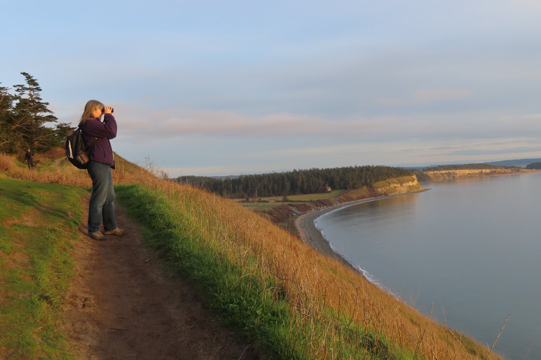 It was a rare sighting on Ebey’s Bluff, a small mammal carrying a small mammal with a cinnamon and white striped tail. A ringtail cat perhaps? But no, I was corrected. It was the endangered red panda, native to the Himalayans, brought to these regions by migrating populations of small homo sapiens. The adorable stuffed animal wasn’t quite as cute as the little hiker carrying it in her arms as she bravely led her parents high up along the bluff trail. But then red pandas are known to inhabit steep slopes, so it was only right that it should take the lead. This stunning trail attracts people from near and far. We met old friends from Bellingham and made new friends from the island. Some walked dogs, but most walked with friends, young, old, black, white, brown. They strolled the beach, they climbed the bluff, they sat in the grass to take in the view. They brought cameras, binoculars, and of course, phones. My hiking partner politely asked one group of young ladies to turn off the music blaring from theirs. They kindly obliged. It was a good day for a walk. After a week of rain, the clouds reluctantly parted, giving way to a pleasant afternoon. We drove down scenic Hill Road on our approach with it’s iconic view of the bluff. Seeing all the cars along the beach and the crowded State Park parking lot we drove up and across the prairie to climb the hill on Cemetery Road and parked by the Ebey’s Landing National Historical Reserve office. From there we walked by stubby fields and the historic Jacob and Sarah Ebey cabin. Following the fence line on the Ridge Trail we arrived at the bluff. The initial 300 foot drop and the expansive view over the water is breathtaking. It brought back so many memories, the times I’d brought my family here when they were visiting from out of state, the group of friends who once walked with me on Christmas Day as the cold wind cut through us like a knife, the farewell party with old hiking partners before I left to hike the Appalachian Trail. This trail was on the cover of Sunset Magazine 20 some years ago listed as one of the Northwest’s “best kept secrets”. It’s no secret anymore. It may be the most popular trail on the Island and well known throughout the region. When people ask me, “What’s your favorite trail?” this one comes quickly to mind. Though I try to steer people to lesser-known trails to spare this one from overuse, Ebey’s Bluff is special. It’s got enough of a climb to get my heart pumping and the views are spectacular all along the 5.6 mile loop. It faces south so even in winter, if there’s any sun at all, you’re in it. (Of course, you also experience the full force of foul weather on wet and windy days.) You can see Mount Baker across the prairie to the northeast, Mount Rainier over Puget Sound to the southeast, and the entire Olympic Range to the southwest, over the wide expanse of Admiralty Inlet. Crossing ferries add their charm. I’ve seen whales from here, windsurfers, eagles, and hawks at eye level. A few years back I watched the start of the powerless Race to Alaska with every kind of sailboat starting out from Port Townsend (https://r2ak.com/). On this day, we enjoyed a leisurely stroll along the top of the bluff but decided not to go down to the beach to make it a loop hike. Instead, we stayed high above Perego’s Lagoon at the edge of the wind whipped trees and retraced our steps. As we began our descent back to the fence line and the Ridge Trail, we paused to take in a glorious sunset. What a perfect walk. We felt fully blessed to live in such a paradise as this. Maribeth Ebey’s Landing National Historical Reserve is managed by an interagency board and includes over 17,500 acres on central Whidbey Island, on public and private property. Get details and see a MAP (Scroll down for the Bluff Trail): Directions: There are 2 ways to reach the Ebey’s Bluff Trail.
From Highway 20 at the stop light in Coupeville, go about 100 yards north to S. Ebey Road and turn left (south). Drive about a mile and a half to the beach. You’ll need a Discover Pass to park in the parking lot. Or you may find a spot on the side of the road outside the gate. OR go north from the Coupeville stop light about 200 yards to Sherman Road, turn left, then veer right onto Cemetery Road. Follow the road to the top of the hill to park by the Prairie Overlook. Or continue, slowly and carefully, to the parking area by the Ebey’s Landing National Historical Reserve office. Walk south toward the Jacob & Sarah Ebey cabin and blockhouse which may be open in the summer with interpretive displays and docents. From there, follow the fence line toward the water on the Ridge Trail, to the Bluff Trail. (You may also visit Ebey family graves in the Cemetery within the white picket fence.) There are restrooms at both trailheads. Bus and Bike: Fare Free Island Transit Route 1 bus can stop at Sherman Road where you can walk the bike path north to the Spur Trail that leads to the Pratt Loop that leads to the Ridge Trail and the Bluff Trail. Just keep walking south. This will add another mile and a half (round trip) to your 5.6 mile Bluff Trail loop. Mobility: Most of this hike is narrow and on a steep slope, with a steep climb to the top of the bluff. However, one could enjoy time at the beach near the beach parking lot, where there are picnic tables and restrooms, or starting at the Ebey’s Landing National Historical Reserve offices, go south as far as the Jacob & Sarah Ebey cabin on a rough but flat, farm road. |
Authors
Maribeth Crandell has been a hiking guide in the Pacific NW for over 20 years. She's lived on Whidbey and Fidalgo Island for decades. As a frequent bus rider she easily makes connections between trails and transit. Archives by date
May 2024
Categories
All
|
 RSS Feed
